Updated: Sam & Dave’s “Excellent Motor Parkway Hike” VI: Broad Hollow Road

In the sixth post of the "Excellent Motor Parkway Hike" series, Dave Russo and his 11-year old son Sammy explored the Motor Parkway around the location of the Broad Hollow Road Motor Parkway Bridge and the Huntington Lodge, the future home of Maureen Standish.
On Sunday, April 2, 2017, Dave Russo and his 12-year old son Sammy embarked on their third annual "Vanderbilt Day". Instead of duplicating the Queens to Melville route, they decided to hike the "unknown" sections of the Motor Parkway from Bethpage to Dix Hills.
Dave Russo April 2, 2017: "The original plan was to start at the Maxess Road Bridge and work our way east but we feared that would not be long enough so we decided on a new starting point.....The starting point was Stewart Avenue in Bethpage and we made our way to Dix Hills. This time we left the bikes at home and walked 13 miles. And not a normal 13 miles, there were large portions of the exploration through woods, thorns and thickets. We both came out with many scratches and bites, but at the end of the day we completed our mission and can add another chapter to the memory book!"
Enjoy,
Howard Kroplick
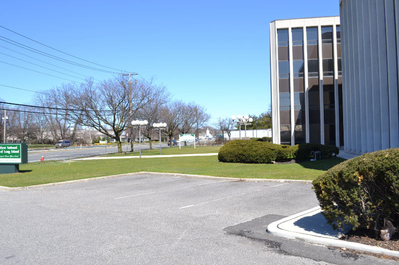
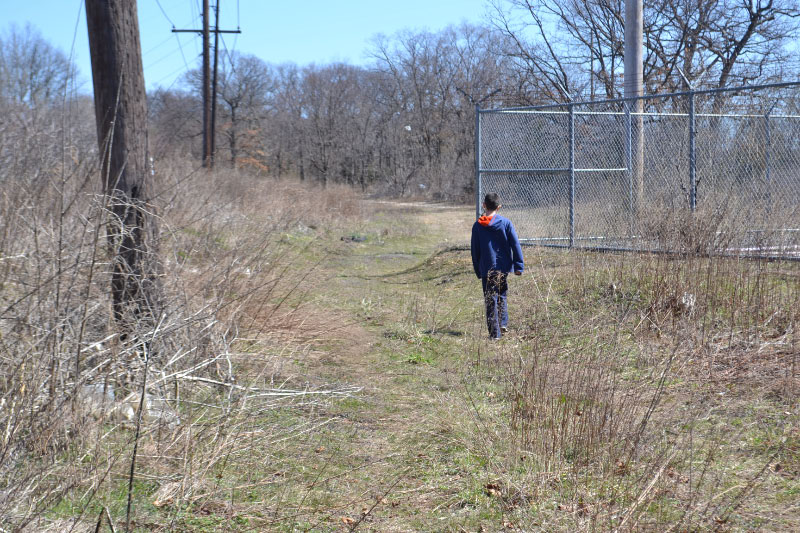
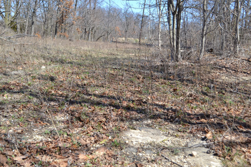
We proceeded east over Route 110.This is a great unknown location but easy to get to. Park behind 555 Route 110 and go explore!
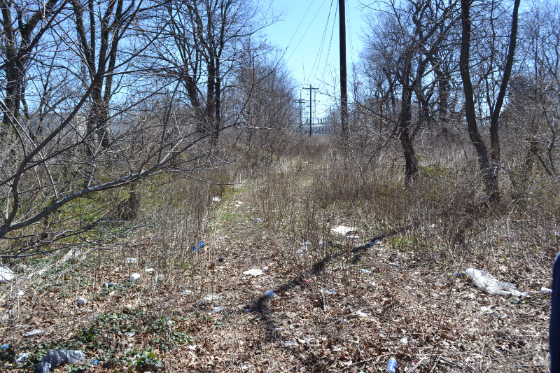
Heading east.
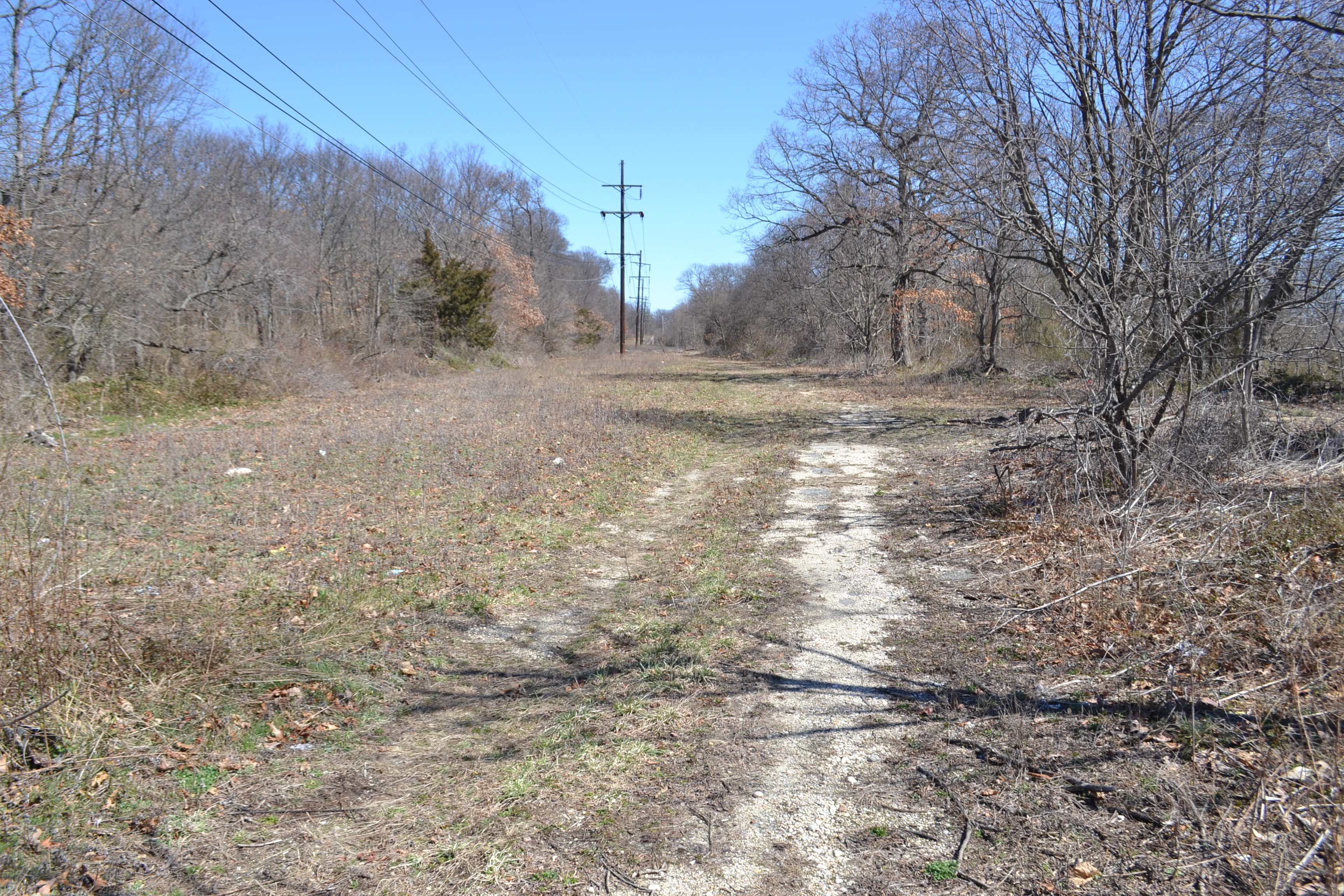
Road fragments are everywhere.
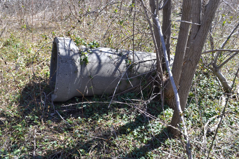
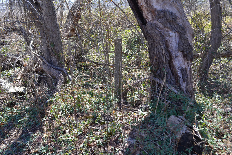
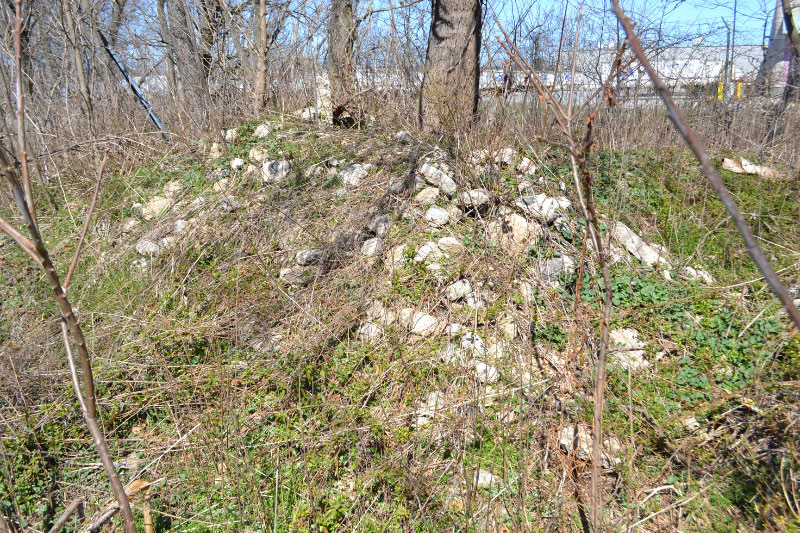
There are posts in here.
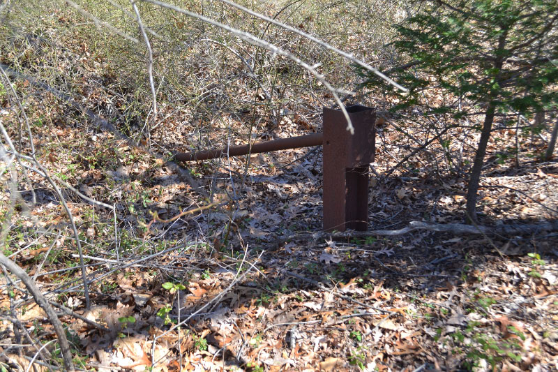
This was interesting - some sort of gate piece? This post sticking out of the base looks like it was adjustable up and down and it extends into the ground here.
Motor Parkway pavement - and off in the distance we can see Maxess Road and another historical marker.
Femenias' Findings (Submitted by Frank Femenias)

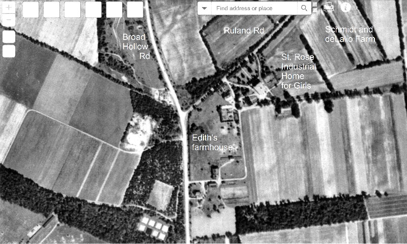
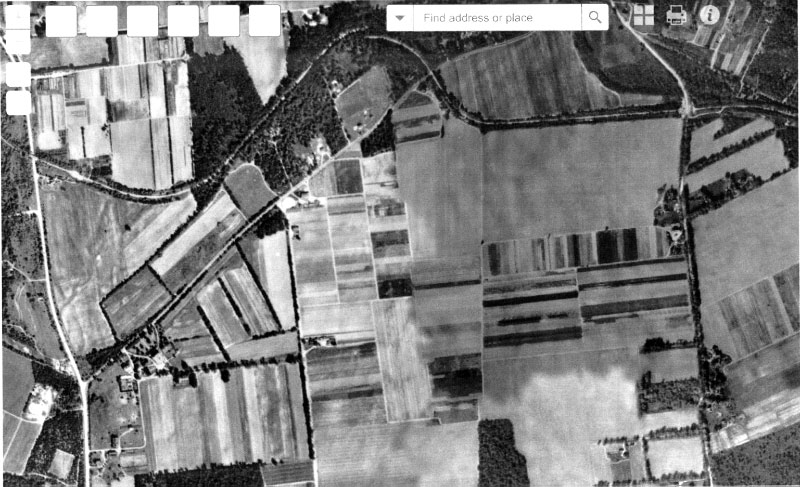
Updated 4/4/2018: After scanning the Melville area in 1947, I may have found Edith's farmhouse. Keeping my fingers crossed.

An overlay for Edith's farmhouse. I was truly hoping for any remnants there. Can't win 'em all I guess.
Site of Edith Klarmann's home.
Edith Klarmann: Don't rightly know if this is the way to make further reference to the Hairston's Property that I have been referring to abutting the LIMP; that said, attached is a foto taken off a current street view of Google looking West the rear of which and up the hill is the LIMP or what is left of it, with the house being precisely as I remember those many years ago.
Femenias' Findings (Submitted by Frank Femenias)
Edith's frequent bike ride across Melville. What a hilly situation this must've been. Stepping back a bit, it seems very similar to the hilly ride on the Motor Pkwy greenway in Queens today.


Comments
Hi Dave/Sam. Always liked this area, especially behind the substation and then due east towards Maxess Rd. The roadway is decent looking for being almost a century old.The pipe gate looks similar to the type that LIPA or PSEG use for truck access into their ROWS, etc. But this one doesn’t look to be useful anymore lol. What is it about concrete posts? It’s always neat coming upon them.
This is a great, very easily accessible location that it seems like not many people know about. It’s quite confusing actually as the LIPA lines and path run south of RTE 110 and it appears as though that is the LIMP ROW but it’s not. I’m sure this confuses many people….I know Sam III was thrown off by this as his site seems to show that LIPA path as the ROW but it’s NOT. Wayne’s map is 100% correct with this location - initially it was confusing but it’s definitely right as the pavement and posts are all visible. Go and explore!
So Brian you think that post and gate are LILCO/LIPA related? Why would they cut off access to their own path?
Vanderbilt Day IV will be happening in the next week or two, exact date TBD but the mission is to start just west of Lakeville Road, behind the hospital, and then proceed through all of Nassau in detail and finish again at the Maxess Road bridge.
Does anyone have any ideas as to possible unknown exploration locations? Are there any thoughts? Howard shared a great idea last year, the Mineola/Albertson location just south of Sigsbee Ave and that turned out to be a great find with lots of LIMP pavement remaining.
Anyone????
Excellent coverage Sam and Dave! You guys always go all out. Some sections seem to be untouched and preserved still. Hoping these stretches will also connect to the proposed greenway in the making. Seems that’ll be the best way to preserve the remnants of this historic roadway. It should never be discarded.
Hi Dave. The utility has these pipe type gates or barriers to keep other’s from dumping refuse on the ROW. When these gates are actually working, one side is locked ( utility employees have the key of course if truck access is needed to perform work, etc. ). I recall 3 types of gates…Chain Link, “sliding” pipe type, and “hinged” pipe type. PSEG LI ROW between Shelter Rock Rd and New Hyde Park Rd ( LIMP & Old Courthouse Rd Hwy Bridge ) is a good example. There’s a hinged pipe type entrance gate on the W/S of Shelter Rock Rd. After unlocking one side of the pipe ( pipe is resting in a I BEAM ), you then have to pull/push the pipe enough to get your vehicle into the ROW. The other side of the pipe is “hinged” in a I BEAM. Have a can of WD-40 handy being that the hinged end becomes quite rusty. And then on the E/S of New Hyde Park Rd, there’s a tall chain link gate that’s much easier to open, providing it’s not being strangled with vines.
Frank—-I hear you but I really kind of love the “untouched and preserved”. The Greenway is a great idea but that will end the history to some degree. Dead Mans Curve has to remain as it is. No changes. I feel that way with many sections!
Brian—-makes total sense. Thanks. You two have to give us ideas for exploration! Any ideas??
Hello,
Really appreciate the pics of the motor parkway. I just had a light bulb moment and remember walking east bound from my home at Huntington Lodge. When I would go to the parkway, take a right to go east, there was a foundation on the north side of the parkway shortly after walking east. This could have been around a 1/4 of a mile from old rte. 110. The foundation was of a sandstone color and not of the gray cement color you see now-a-days. There was much over growth of scrub brush and the top of the foundation wall was weather beaten. Has anyone ever come across foundation remains while hiking this area? The size of the basement could very easily fit to the actual lodge. There was also metal and/or pipe fragment scraps in the foundation.
I think Howard was right, the lodge was moved to the location where I lived.
Maureen
... continuing East from the start of Colonial Springs Road, look to the first house on North side (Visible via Google map, with the house just as I recall), then behind the house and up the hill is the LIMP (again the route of LIMP easily seen). Indeed, if I were not now handicapped with a walker, I would go to the house and tell the owners that their house was once owned by the Hairston Family (the husband/father, a Southern gentleman with hound dogs he kept there, and who was the Commissioner of Elections for Suffolk County), the house being to where we would ride our bikes to visit Mrs Hairston… recalling, as I have previously remarked, how we would bike from our farm house on Route 110 (2 lane) at the Huntington/Babylon town line to the LIMP bridge and then go uninterrupted all the way to a point on the LIMP directly behind the Hairstons, where we would get off our bikes and walk down the hill to the back of the house. Perhaps a bit repetitious, but seeing the Hairstons house today as it was in the mid fifties, suggests that there may yet be the odd reminder of the LIMP directly behind the Hairstons house. Anyway, that is how I remember it. Edith
Happy Easter everyone.
Dave- Maureen has an excellent idea of inspecting the original Huntington lodge’s foundation by the north side of the RoW. Although this area has been rebuilt over the years, there’s a chance of discovery closer to the parkway. I quickly drew up an overlay of the 1930 and 1947 lodge locations (see attached, sending to Howard).
It looks like both foundations are in the paved parking lot, Darn! As Al Velocci noted, U-turns at this lodge were permitted and made by motorists mostly coming from the west, without privilege to leave and return. So a round trip, one dollar toll from Queens was possible from here. I sketched the yellow lines where the driveway was and where auto activity occurred with the U-turns. It looks like Broad Hollow Rd was eventually expanded eastward.
If you and Sam are visiting here soon, it wouldn’t hurt to take a closer look. I included coordinates if it helps
Dave, please be more specific; I have many old references that are “off” (and would be happy to correct) but the only places I recall being seriously confused by LIMP vs. LILCo in that area were on the east end of Bethpage State Park and the south side of Spagnoli Road just west of 110. East of 110, the RoW is the south boundary of the USPS’s Mid-Island Processing and Distribution facility. An I mistake me not, Howard has already fully covered the RoW on the west side of 110 under the parking lot ramp on the south side of 576 Br. Hollow Road. By the way, “south of RTE 110” puts you in South Oyster Bay, the west end of Great South Bay! Sam, III
Edith- Glad to have you back. We are in discussion about the Motor Parkway’s Huntington toll lodge in Melville, just up the block from your childhood home south of Ruland Rd. Maureen Standish actually lived in the lodge after it was moved just south from its original location. About your same age, do you recall Maureen, Teddy Barley, or Patty Krewatt? You all lived in the same area around the same time. What a thrill it would be to see childhood friends reunite.
Maureen- Based on your description, it could’ve very well been the old foundation to your home. I measured the distance of this foundation from Old Broad Hollow Rd and got about 1/10 mile. I fear both foundations have been covered up with asphalt from the existing parking lot. Standing by for Sammy and Dave’s exploration results of this area! If time permits, I’ll take a run over there after the snow stops. It’s snowing here again!
Sam III- North of Spagnoli Rd, 576 Broad Hollow Rd’s southwest corner is correct, where the curvy LIMP descended from the bridge.
Hello,
I have been on google maps today looking at the area around 555 Broadhollow Road and Spagnoli Rd. I feel, if one drove right across 110 eastbound, you would be right on LIMP. I took a good look at the old tree growth and when I look back at my picture of the Cub tractor, to the back of the property looks very similar. Take a look and see what you think (40.762 - 73.423) I also noticed the ground to the left of the tree growth by 110 slopes up. This could be what remains of the area to the old overpass.
Regarding the old foundation, I could have been off and would say not less than 1/8 to not more than 1/4 mile to the left of the parkway from the center of the old 110. When I look at the posted pic, there is now the utility line with a grass cutback. The foundation would be just to the north of the cutback where the tree line begins. I would assume LILCO would have graded all that in.
Can anyone tell me how I can go online and get property info regarding the purchase and/or sale (1953) of my parent’s property or a tax map? This would really put an X on the spot and give measurements.
Boy, this stuff can be fun but addicting. 😊
Maureen
Edith,
I have come up with another name from my childhood in and around the Huntington Lodge area. That name is Stephen Abramowski. He was in my class at the Sweet Hollow elementary school in 1951. I did sent a pic of the class to Howard. I am in the front row center with the bowl hair cut. Did you attend this school by any chance? Sorry to keep putting out this information in small drips but digging into the gray matter of the brain from sixty plus years is a slow process. One cell at a time must be examined.
Maureen
Edith Klarmann:
Names are not familiar. however, let’s re-orient, that is—starting with the junction of Ruland Rd and Broad Hollow, going East on Ruland, the first structure (right side) would have been St Rose Indusrial Home for Girls, then next road, again to right would be Republic Road with the Nohile farm on the corner, all along Ruland would be the LIMP paralleling Ruland till where the LIMP then crossed over Ruland, and from here maps will show LIMP continuing to then parallel Colonial Road for a short distance, and that is it for me. That said, what might there be of fotos in this area, and were if not for me bum leg and walker I could better identify landmarks, though, for now, this should help. As to the St Rose property, it continued along Ruland to Republic Rd, the east side of which was Schmidt and deLalio farms; originally, St Rose property continued to just short of deLalio farm where it then turned West to Broad Hollow Rd and along to Ruland to complete their boundary. Incidentally, we lived in the green shingled farm house east side, first house in Huntington Township, it was a big old farm house with a wrap-round screen porch; West side of Broad Hollow was the Long Island Aggie School. Hoped this was helpful.
Edith
Frank: again your attention to detail and map skills are awesome.
Sam III: We have to meet one day. I have a good sense of you I think!! Obviously we are not south of RTE 110. You know what I meant! I recall looking at your site and you showed the LIMP east of Spagnoli Road crossing over RTE 110 - there are LIPA lines there and a path and it appears to be the LIMP but it’s not. The ROW is north of this location, behind 555 RTE 110 really to the north side of the parking lot even. Don’t worry, with the tools you had at the time you did fantastic/amazing. A true leader in this quest. I thought it was correct too until I saw Wayne’s map and decided to check this northern spot out. LILCO threw us off on this one.
Maureen/Edith: Great discussion. Glad this great site enabled you to re-discover and reminisce! Check out Wayne’s online map of this zone, and Frank’s post as well above but Wayne’s map will give you greater detail with the surrounding area. As you walk through the northern part of the 555 RTE 110 parking lot heading east you quickly find the LIMP ROW. There is no doubt this is it. Posts are still in place and pavement fragments are everywhere. The first large pic that Howard posted above is not very far in and it is on the northern side of the ROW, exactly in the location you are discussing. This large pile of debris is also elevated as you can see. Maybe this is something? I just sent Howard another pic a bit further east then this first location with similar characteristics. You can see the USPS facility in the background so you know you are on the northern edge of the ROW. I definitely recall seeing large piles just south of the ROW as well but I have to investigate further. Will keep you posted if we find anything new/better!
Hello all…is there any thought regarding the Sugar Maple Drive area in Albertson? I am an employee of the Viscardi Center and have often thought about how far that arc actually swung out, i.e. that there may be some remnants near the now track, in the wooded area.
Edith Klarmann:
Maureen,
Time wise… did not go to school in the area, and didn’t know a Abramowski. we were quite isolated being at the Southern extreme of Huntington Township—property following ours South on Broad Hollow Rd was in Babylon Town, and except for the Nohiles, deLalios and Hairstons didn’t know any others.
Edith,
Maureen- This website may have info on your property. Hope it helps.
http://www.suffolkcountyny.gov/Departments/CountyClerk/OnlineRecords.aspx
Edith- If I read your directions correctly, I may have found your farmhouse and neighbors in 1947. This was the first house north of the Huntington boundary along Brush Hollow Rd. See attached photo and please let me know.
Frank Femenias:
After scanning the Melville area in 1947, I may have found Edith’s farmhouse. Keeping my fingers crossed. See above overlay.
Edith Klarmann:
Thanks Frank…
Very close… so, let me see if I can bring it all into focus:
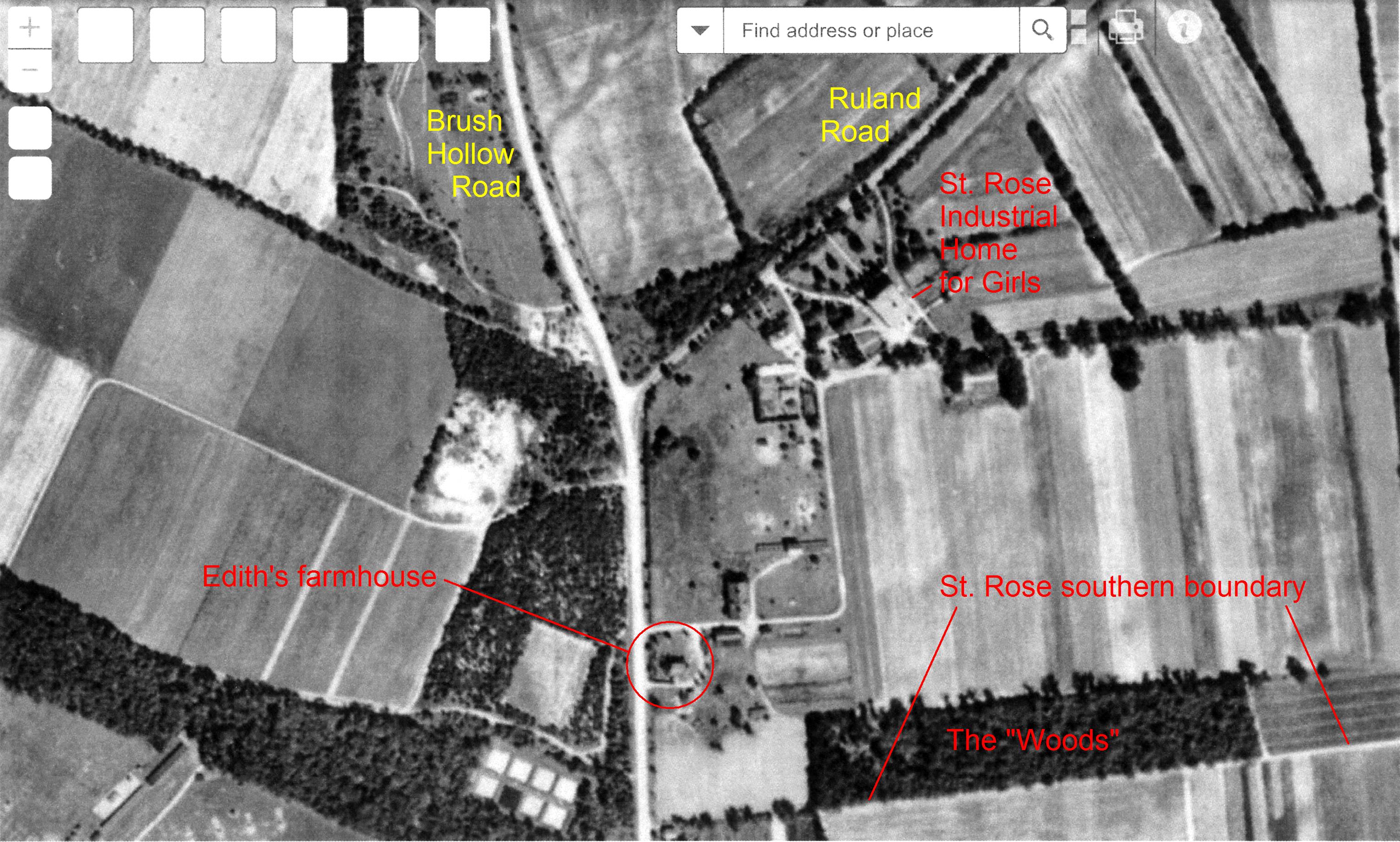
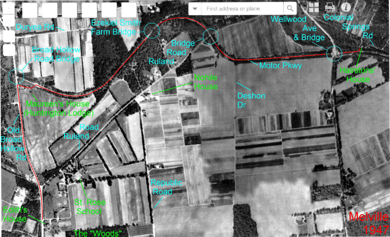
1) as to Edith’s Farmhouse: starting with Broad Hollow Rd North—just past that large white block on the East side is that white square, where, just inside is the farmhouse, then on the far side (North) follow that white path to where it then turns North to the clump of buildings. Then, re-orienting at Ruland Rd, leading off is what appear as a pair of arms terminating at the white block, which is St Rose (the Big House as we called it, our green shingled farmhouse was the Green House). As to the Schmidt and deLalio farms, the foto does not go far enough East to include them. However, again to the bottom of the foto, there is that black path of trees (here, we referred to that as the “woods”, everything had a name). At the far end of the woods was Republic Rd, which was about the boundary of the two farms on the East side of Ruland Rd. All in all, close enough to say: give the man a cigar.
2) And since we have gone back in time to around the mid forties, perhaps someone recalls a Grumman TBF crashing in Wyandanch late in the War. Actually, as I recall, unless there were two, that TBF crashed into the line of trees bordering the West side of Republic Rd on St Rose property, for, if he was jus a few feet higher, the TBF would have landed in St Rose’ potato patch. Anyway, thought that I should make note of that before I forget it something else as happens with the passage of time—now being just shy of 81.
Again, thanks all for helping me relive that time, if only in fotos.
Edith
Edith Klarmann:
Frank,
As described… within little square box, just the other side (North) of the large white rectangular white box, is my farmhouse… that larger white rectangular box being a cultivated farm field. Further, the South saide of the Woods being the Southern boundary of St Rose. Now, to complete the search, moving along Ruland Rd should then show the LIMP to iots Left or North side til the LIMP then crosses over Ruland, picking up the LIMP towards the beginning of Colonial Springs Road might havethe odd artifact considerng the remoteness. In any case, thanks again.
Edith
Frank—-so you think Edith’s house was SOUTH of Ruland Road? This is not in line with the previous sketch you made which was just south of the LIMP, north of Ruland Road.
If you are now correct, there is definitely nothing to see here at this time. This exact location SOUTH of Ruland Road is now is a humongous COSTCO parking lot and store. Certainly no remnants.
Edith Klarmann:
Thank you…
You are absolutely correct - there is now nothing to see. The property was sold in 1987 and now has the same characteristics as that of the sand pit off Route 110. For my part, I was responding to the 1947 (or
thereabouts) aerial view and correcting the locations identified. What I did say was that if there was anything left to see, based upon personal knowledge I thought that would most likely be the area behind the former Haiorston’s property at the beginning of Colonial Springs Rd… even back then in the late forties there was a foot path leading to and from the rear of the house—nothing more, just a small journey from yesteryear, and for which I am appreciative.
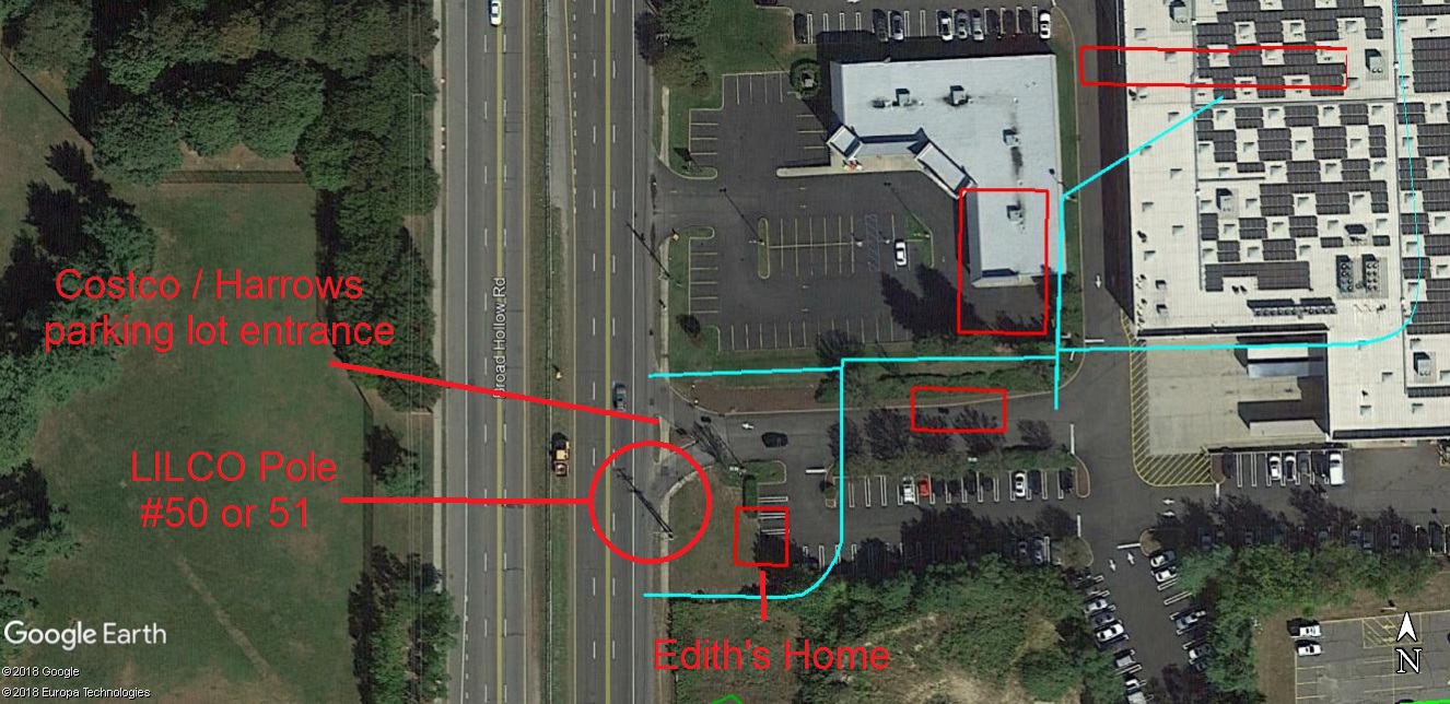
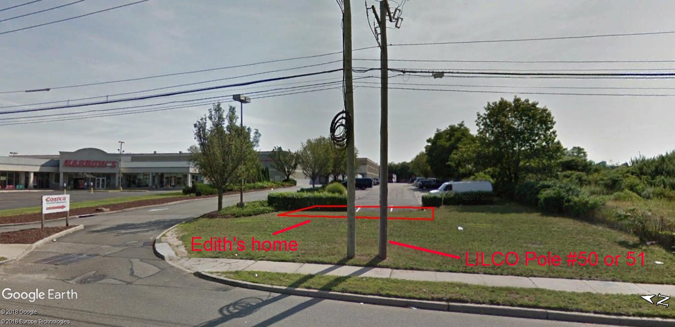
What I can also tell you of that time is how isolated we were. Even though we were on Broad Hollow Rd / Route 110; for example, the LILCO poles were all numbered, with the one directly across from the house was No.50 or 51, and for calling for Police, it was the State Troopers or Huntington Town, though the preference was for the Troopers as they were all well turned out, but then this is about the LIMP which I continue to follow in the expectation that information might appear which will be of interest to me.
Edith
Edith, the location you speak of approaching Colonial Springs Rd is coming up next in our HIKE. Stay tuned!
Edith and Dave, etc. - re Dave’s continuance, you folks might have a look at my Half Hollow Hills coverage from 2002 at <http://sbiii.com/limpsuff.html#halfholl> (scroll ‘way down, past the missing images). Sam, III
Dave, you’ve probably seen these on my site and/or been there already:
http://www.freewebs.com/limparkway/mineolawestburyave1.htm
http://www.freewebs.com/limparkway/mineolawestburyavenue.htm
http://www.freewebs.com/limparkway/mineolawestburyave2015.htm
http://www.freewebs.com/limparkway/mineolawestburyave2016.htm
http://www.freewebs.com/limparkway/mineolawestburyaveso.htm
http://www.freewebs.com/limparkway/oldcountryroad.htm
http://www.freewebs.com/limparkway/stewartavenuegardencity.htm
http://www.freewebs.com/limparkway/levittownsalisburypkdr.htm
http://www.freewebs.com/limparkway/wyandanch.htm
Dave- Edith’s childhood farmhouse was south of Ruland Rd and just north of the Huntington town line (first house in Huntington). The earlier aerial sent was for the two locations of the Huntington lodge (1930, 1947) just to the north of Edith. After the lodge was moved from its original location to the south in 1947, it became Maureen’s childhood home in the lodge.
Edith- I’m sending another aerial copy of the farmhouse with proper labels using a red circle. After you verify the correction, I’ll create an overlay of your home to view where it stood in today’s Costco parking lot. I believe it actually stood in the still vacant lot just south of Costcos. The farmhouse foundation may still be there. Also sending more 1947 aerials of Ruland Rd heading east towards Colonial Springs Rd (a trip down memory lane).
Stay tuned Dave for more possible exploration sites!
Edith Klarmann:
Thanks…
There… now you have it. Both St Rose and my farmhouse correctly identified. And, having lived there for the time when we did, every time I look at the foto I can almost see a bit more than is actually revealed; that is, everything from what we referred to as the “Big Barn”, to differentiate from the older barn, the “Yellow Barn”, then, “Chicken Coop” at the end of the path leading off the one to the “Big House”, which it was, and until WW2 the bell on top thereof would chime out for the noon and evening prayers which could be heard quite clearly. And, for a last look at the map, to recall that until the mid fifties, except for the Noheil farm at the corner of Ruland and New Highway (Republic Rd), our closest neighbor was the Hairstons (house still visible near start on Colonial Springs Rd).
But enough of this memory lane… before my memory starts to fill in the missing bits and pieces. Thanks again… Edith
Thank YOU Edith for locating your home! After sketching an overlay, I was hoping for any remnants still existing of your farm. Only the cultivated field survived (please see attachments). It seems to now be used for storing heavy equipment of some sort. Everything else has been covered with pavement. Your home now sits by the southern entrance to the Costco parking lot. As you said, there’s nothing left to see. But the Nohiles farmhouse location, once at the southeast corner of Ruland and Republic remains a vacant lot. There may be undisturbed remnants still there. Something to look for next time I’m in the area. Thanks again Edith.
Frank
Ouch! My page 8 is unrestored and covers the Mineola-Carle Place segment; including 284 Rudolph Road, the MIneola Lodge, in 2000; the page is in very bad shape and requires a lot of work, Ditto my Central Nassau continuation Page 1, covering Russell and Old Country Roads in 2004 - I’d better get busy! Sam, III
Added a new Femenias’ Findings overlay of Edith’s farmhouse.
Edith Klarmann
Thanks again Frank,
As to the Farmhouse and property… per last foto the property (Edith’s) extends down along Broad Hollow Rad to the Town Line so that if you drew a line along the Southern edge of St Rose property (the Woods) to Broad Hollow Rd you would have the Southern edge of our property.
As to the Nohile property… as I recall, their farmhouse was a combination farmhouse barn, all as one piece, sometimes seen from the olde days.
Edith
Edith- a few interesting facts;
Old Broad Hollow Rd would eventually be expanded eastward by the Motor Pkwy toll house, but expanded westward by your home just to the south. The likely reason for this was to soften Old Broad Hollow road’s sharp curve allowing the roadway today to be more streamlined.
LILCO pole #50 or 51 still exists directly in front of your home today. It was untouched with the roadway expansion to the west. As of Aug 2017, there is a double pole at the location (a newer to replace the older). I’m planning to take a closer look soon before the older is removed.
The Nohile house/barn did have an irregular shape from overhead (not rectangular or square) as seen here. It’s former location remains a vacant lot on the SE corner of Ruland and Republic. Another site to investigate. Brian, are you in?
http://www.vanderbiltcupraces.com/images/blog/East_of_Edith_1_labeled.JPG
Dan- I have the top of the Searingtown arch (bridge) at 60’ away from IU Willets center to center. A closer look here of the bridge.
http://www.vanderbiltcupraces.com/blog/article/long_island_motor_parkway_bridge_series19_i.u._willets_road_motor_parkway_b
Haven’t yet explored the RoW dirt path section but it looks promising. I believe the parkway on the Sugar Maple side rests on the house’s foundations and not in their backyards. Definitely worth a closer look there as well.
TA, RA! My page 8 is now restored, covering the Mineola-Carle Place segment; including 284 Rudolph Road, the MIneola Lodge, in 2000, as is my Central Nassau continuation Page 1, covering Russell and Old Country Roads in 2004. WHEW! (Some of the thumbnails are still awful but the pix behind them are good and I’m not up to redoing the t/ns yet). On to Hike VII!
http://sbiii.com/limpkwy8.html
http://sbiii.com/limpcns1.html
Sam, II
Found my “missing” Maxess pix from 2004/5 - midway down on the Open Items page <http://sbiii.com/limpopen.html> (also so noted on Mystery Foto #11 post of 19 Mar 2018). Sam, III
Frank - thank you for the info and it always seemed like the homes were built on the former roadway. The items that made me second guess it were the maps from the county that outlined the proposals for Motor Parkway Trail Program (arc swung out further) and locals that have mentioned seeing items in the backyards of Piper Lane.
Edith Klarmann:
Thanks again…
Old Broad Hollow Rd… the widening and straightening—straightening, in particular, took the route of the Trolley Line right of way, with the Trolley passing in front of our house (though several years before my time) continuing all the way to Conklin Street (corner of former Republic Aviation), then West to Farmingdale, with a jog to the LIRR station, then to Main and South on Main till it again joined Broad Hollow Rd before Amityville.
Edith
Added two more Femenias’ Findings showing the site of Edith Klarmann’s home.
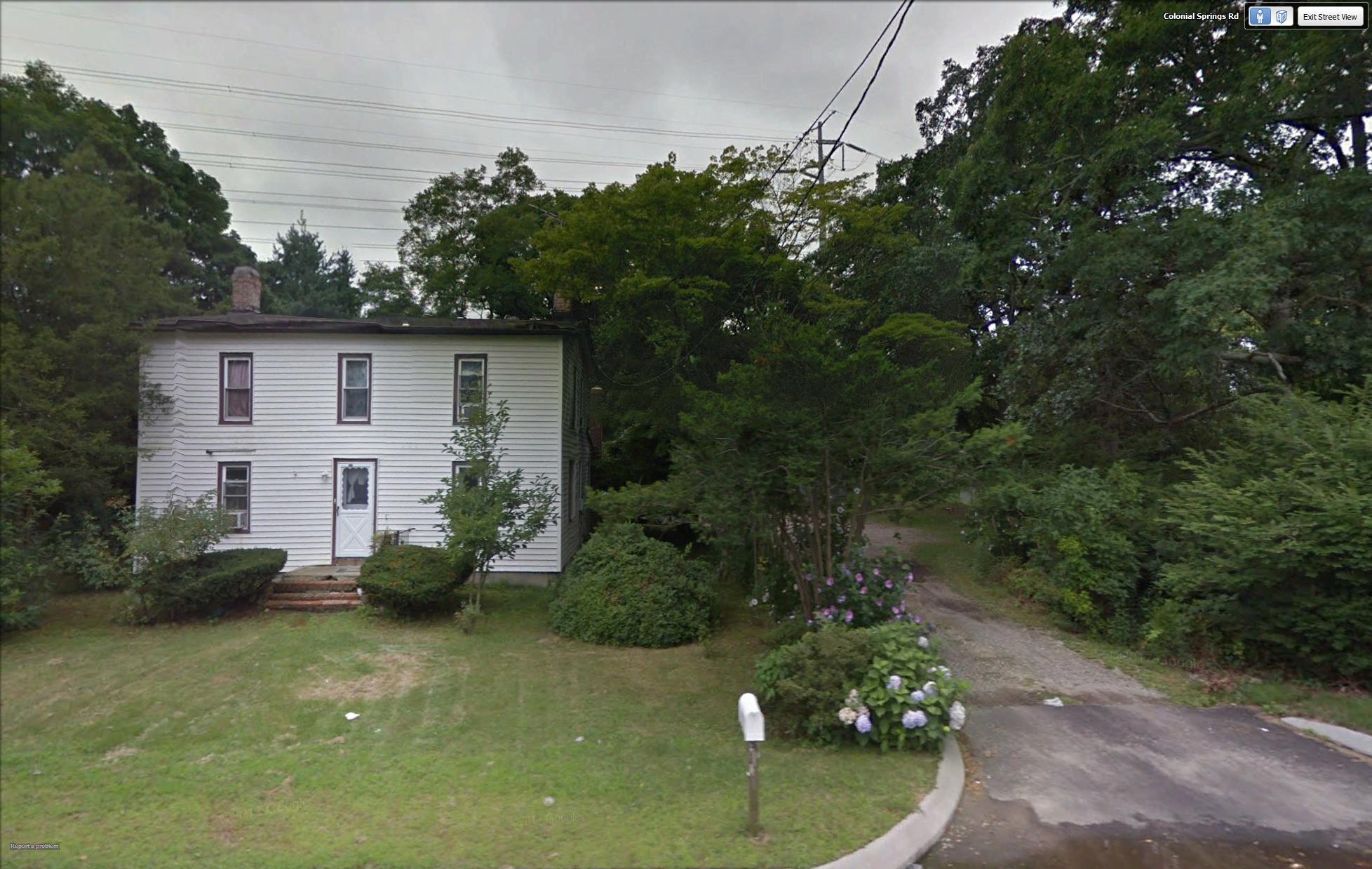
Edith Klarmann:
Don’t rightly know if this is the way to make further reference to the Hairston’s Property that I have been referring to abutting the LIMP; that said, above is a foto taken off a current street view of Google looking West the rear of which and up the hill is the LIMP or what is left of it, with the house being precisely as I remember those many years ago.
Edith
Spectacular find of the Hairston’s house Edith, and yes, you’re in the right place for continued comments. I found the home on Google maps as well and will be sending Howard a 1947 bike route map from your home to the Hairstons’, as per your directions. Your trip was 1.8 miles each way, not to mention the hilly bridges to overcome towards the Hairstons’.
Based on the 1947 aerial, of the three bridges you had to cross to reach the Hairstons’ (not including the Brush Hollow Rd bridge), two were still intact and appear passable (the Ezekiel Smith farm bridge by Maxess Rd, and the Ruland Rd bridge). The one bridge that appears to have already been removed was the Wellwood Ave bridge (Pinelawn Rd), just 500 feet short of your destination.
Do you recall how you crossed the street here in 1947 without a bridge? Did you temporarily leave the LIMP just to cross? You mentioned when accessing Hairstons’ backyard, it was at the bottom of the hill. It’s sounds like the Wellwood Ave bridge embankments were still in place even though the bridge was removed.
When riding your bike in 1947 from home to the LIMP via Old Brush Hollow Rd, you must’ve passed through Maureen’s driveway (on the south side of the Brush Hollow bridge) to gain access to the Motor Parkway. You were so close to meeting your neighbor Maureen
Hi Edith
Explored the Melville area yesterday and took snapshots you might be interested in seeing. Please let me know.
.(JavaScript must be enabled to view this email address)
Edith Klarmann:
Actually, as I recall, we went down Broad Hollow Rd to the LIMP bridge (don’t recall if it was still there) and went on to the LIMP. Alternatively, there was a path opposite St Rose which led to the LIMP and from there we biked as far as we could, crossing that confluence of Roads just before Colonial Springs Rd and continued on the LIMP to just behind the Hairston’s property, which was down hill from the LIMP (the view from the foto is West to the LIMP at the rear of Hairston’s property). I suppose it was the thrill of riding on the LIMP as much as we did, and not taking any interest in what might have been off to either side of the LIMP… you know, like our own private trail. Beyond this, I don’t really recall much of anything else.
Edith
More Femenias’ Findings.