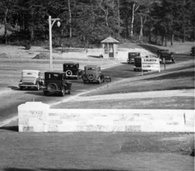
Update- Mystery Foto #9 Solved: The Northern State Parkway Gateway in 1933
New York State Parks, Bureau of Historic Sites, challenged you to identify this weekend's Mystery Foto.
Answers to the Mystery Foto questions:
- Where is this location? What is the orientation of the photographer?
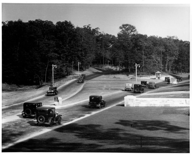
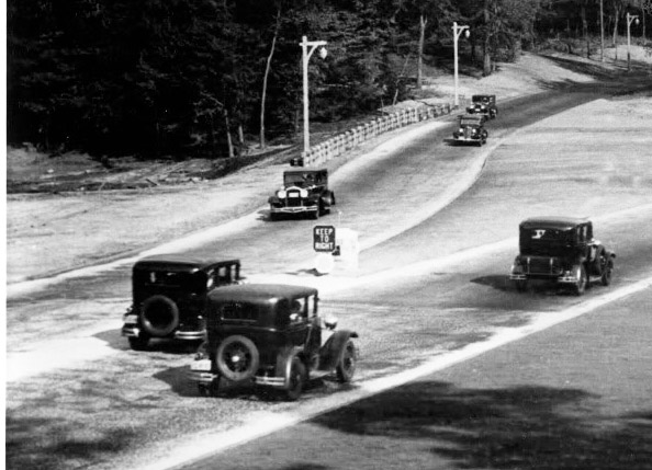
As described in the Arcadia Book North Hempstead by town historian Howard Kroplick: Northern State Parkway Gateway. A little morethan two years after the cornerstone ceremony (see below), the "gateway" to the Northern State Parkway and North Hempstead was opened for business. The gateway was located on the Queens/Nassau County border indicated by the wall. The photographer was looking east.
- What is the date of the photo? Provide a rationale.
October 8, 1933. Rationale: The Arcadia impage caption and the year of the automobiles.
- Kudos question: Link the Mystery Foto to the Long Island Motor Parkway
The Long Island Motor Parkway crossed over Northern State Parkway just east of this location. Moreover, the opening of the toll-free Northern State Parkway helped lead to the closing of the Long Island Motor Parkway in 1938. William K. Vanderbilt, Jr.'s estate was located to the left of the Mystery Foto.
Comments (14)
Congrats to Joe Oesterle, Greg O., Frank S., Al Prete, Steve Lucas, Sam Berliner III, Tim Ivers, Frank Femenias and Al Velocci (my favorite co-author) for correctly identifying the Mystery Foto.
Kudos to Greg O., Al Prete, Steve Lucas, Frank Femenias who linked the Mystery Foto to the Long Island Motor Parkway.
Enjoy,
Howard Kroplick
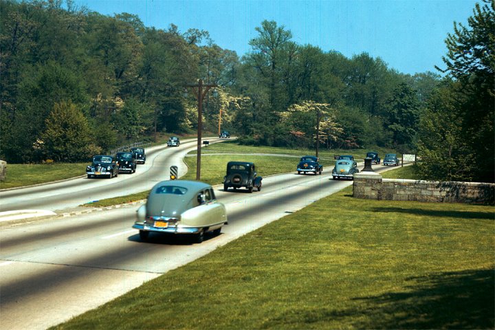
Another view of the Northern State Parkway Gateway. Coutesy of Greg O.
Can anyone identify the year and make of the two-tone automobile approaching the border between Queens and Nassau County?
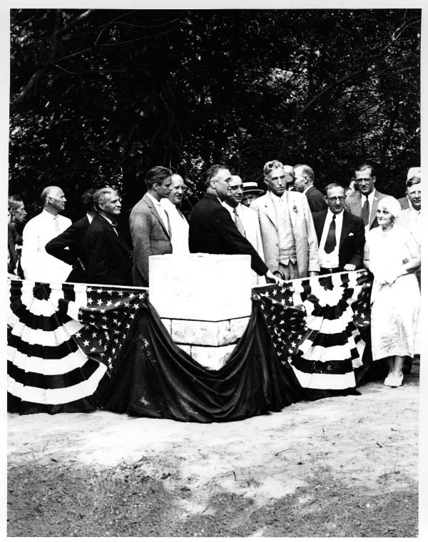
Northern State Parkway Cornerstone Ceremony, July 26, 1931. Governor Franklin D. Roosevelt participated in the gateway cornerstone ceremony with Robert Moses, chairman of the Long Island State Parkwat Commission (right of FDR). Courtesy of New York State Parks, Bureau of Historic Sites.
Close-Ups

Then & Now: Submitted by Brian McCarthy
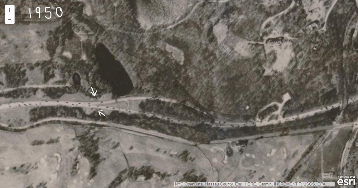
Brian McCarthy:The gateway wall is quite clear on this 1950 Land Record Viewer aerial ( white arrows ).
The Motor Parkway can be seen on the far right.
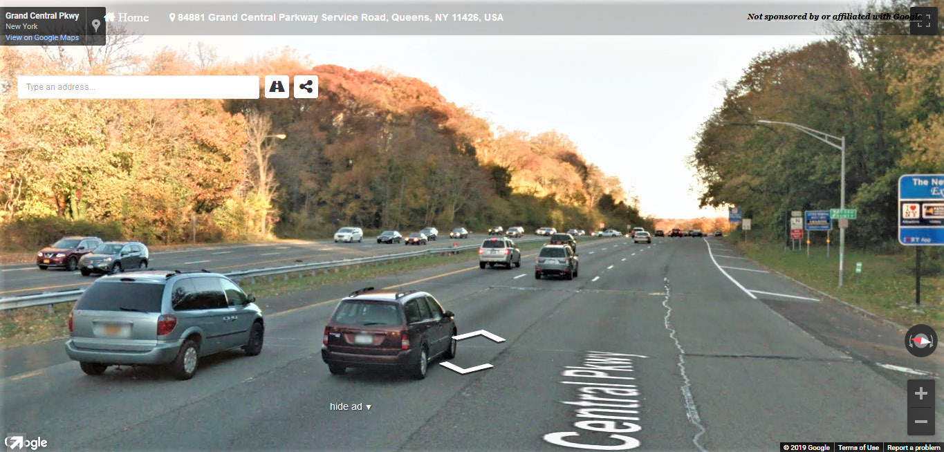
Brian McCarthy: A 'now' view of the Mystery Foto.
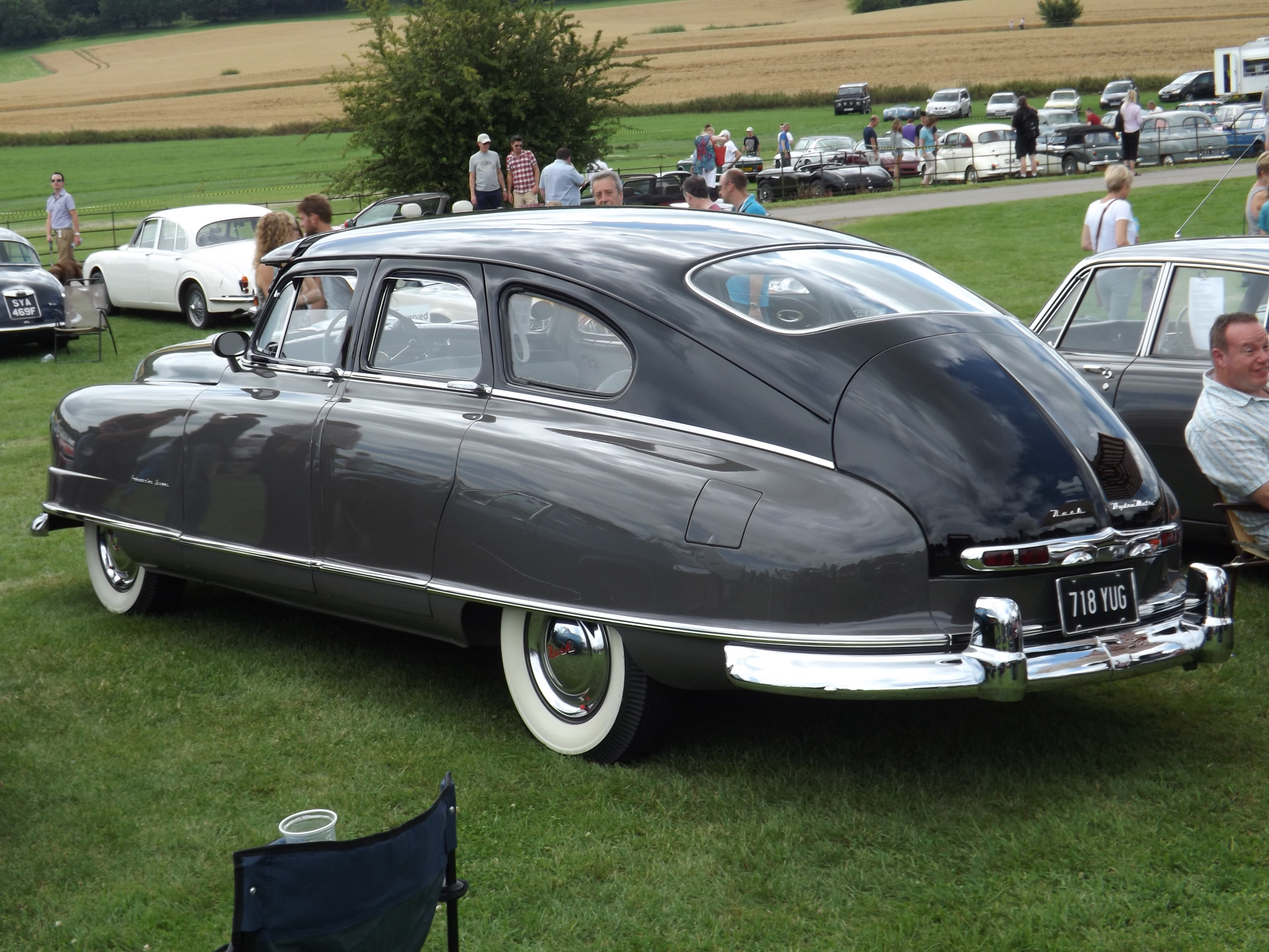
1950 Nash Ambassador (Submitted by Greg O.)


Comments
I will say Grand Central Parkway, at the NYC / Nassau County Line. The wall we see is actually the county line marker. We are looking east.
Had to laugh. Not only did I immediately recognize this one, I actually already had this one in my hard drive!
-Where is this location? What is the orientation of the photographer?
Grand Central/Northern State Pkwy looking East at the Queens/Nassau county line.
-What is the date of the photo? Provide a rationale.
If I recall correctly, this photo is from around 1931
-Kudos question: Link the Mystery Foto to the Long Island Motor Parkway
Willie K’s Deepdale is just off to the left. Just beyond this photo would be his hunting lodge and future NYS police barracks also on the left.
Revising my answer to the date; photo taken on October 8, 1933
I think it’s the beginning of the Northern State Parkway looking east.
The date must be in the 1930s. It was built by Robert Moses to replace the
Motor Parkway
Howard, I think this is a view of the western end of the Northern State Parkway looking east. The light poles are in the style that was once used all over the Long Island parkways, the parkway had a wide median before the road was widened, and I remember the wall that indicated that you were leaving Queens and entering Nassau. Entrance to westbound road from Lakeville Road is in the middle of the photo, among the trees.
The photo must have been taken around the parkway’s opening in 1933, judging by the style of the cars.
Connection to LIMP: It crossed the road just east of here.
We are looking east at the Queens - Nassau border where the Grand Central Parkway becomes the Northern State Parkway. The date is October 8, 1933 and my rationale is that a certain author says so on page 71 of a certain book about North Hempstead. I believe the link to the LIMP is that most if not all of the land in the photo was once a part of Willie K.‘s Deepdale Estate.
My comment isn’t nice. Why do you do this to us? Far too often, your blowups aren’t big enough to make out any detail. I know - complaints, complaints. I vaguely remember some such from my early childhood (late ‘30s) as being at the Nassau-Queens line heading west on Northern or Southern State Parkway. ??? Sam, III
Guessing Bethpage State Park entrance, looking north. Early 1930s.
Motor Parkway ran through today’s park.
Great photo. Looks like the North Shore - Post Road area. Just a guess!
Looking east at the Queens/Nassau border on Grand Central Parkway where it connected to and became Northern State Parkway around 1933. The autos are pre-1934.
What a great shot! This is exactly where Queens County meets Nassau County and the GCP meets the NSP (at the stone wall). Photographer is looking ENE. The NY State Parkway Police Barracks was once just down the road 1/4 mile on the left side. Also on the left behind the trees was Willie K’s Deepdale Estate (the Motor Parkway link?). The barracks was once the Deepdale guest house 1902-1910. The parkway held this configuration in 1950 but the cars are much older. I’m guessing this photo was taken in 1933 when the parkway first opened. Many of today’s highway safety devices are missing here, especially the center divider and that stone wall is begging to be hit. I wonder if it ever was? Mr Ivers from the police barracks may know.
Just a thought, if this is 1933 Robert Moses’ toll-free parkway here has just numbered the remaining days for Wille K’s struggling and expensive Motor Parkway. Only 25 years old and quickly outdated, most simply could not afford the dustless ride. I’d bet that every passenger in this photo at the moment is ecstatic, wearing a grin from ear to ear. I still want my parkway back! Happy Motoring
Howard, we are looking eastward at where the grand central parkway ends and the northern state parkway begins. Probably 1933 when the two parkways opened. the autos heading east will go under the motor parkway in about a thousand feet.
Mystery Foto #9… The road looks like the entrance/exit to Bethpage State Park but ... my research gave me nothing to back this up. Based on the autos on the road I would say photo was taken in 1928 or 1929.
I the photo I submitted, I believe the 2 tone car is a 1950ish Nash Ambassador. Jay Leno not surprisingly has one.
https://www.youtube.com/watch?v=oGopLn5Apf8&t=892s
The two-tone car in Greg O.‘s photo is a 1950 Nash Ambassador.
The Question…Can anyone identify the year and make of the two-tone automobile approaching the border between Queens and Nassau County?
The answer…The car in the color photo of is a 1950 Nash Airflyte Statesman.
In Greg’s photo, that’s either a 1949 or 1950 Nash Ambassador.
Looks like in 1950 Nash statesman
I thought maybe this was close to a state park off the NSP. Guess the gateways are gone presently due to road widening? Sure everyone noticed the small octagon shaped booth structure. Willy K donate a kiosk to Robert Moses?
Brian - Here is a link to the GCP/NSP expansion over time. Also included the Police Barracks just down the road, which is now consumed by the NSP westbound lanes. Not sure where the booth came from but possibly used by the troopers to stop commercial traffic from proceeding east towards the low bridges up ahead. In my opinion the booth too is sitting precariously close with no protection by the speedy roadway .
https://www.google.com/maps/d/viewer?mid=1396j0_672hYkvbcNFJInbc1mXNJspD9f&ll=40.75951529853337,-73.70957339193177&z=17
“Speedy roadway”, Frank? The limit then was 35mph! So I was turned around in my recollected orientation but I KNEW I’d been there. I started driving the parkways (extra-legally in NYC at first) in 1950 and it didn’t jump up to 40mph until a bit after that. Did anyone pick up on the SECOND two-tone “bathtub” Nash in front of the Statesman? I’d say that’s a 1940 Buick approaching at left, preceding two ca. ‘38 GMs (LaSalle/Caddy?), and there’s a 1942-48 Chrysler product leading the lineup at far right (by the sign). An I recall me aright, that small dark sign facing east above the Statesman read “NO TURNS / POLICE VEHICLES ONLY”. Sam, III
Still keeping up with what’s happening,but this time I have to answer. I knew the answer to the two tone car,but you didn’t give the answer yet,is it a Nash? I knew right off the bat,because one of my neighbors had one,when I lived in Brooklyn. I wasn’t sure about the rest and don’t have time to research it,so till next time,keep history alive.
Howard Kroplick
New photos submitted by Brian McCarthy and Greg O.
I like that sporty roadster with the light top in the center, looks like a ‘30 or ‘31.
Brian, just updated the online map for the gateway walls and located the south wall on the dirt shoulder exactly at the dark blue “Litter Removal ” sign (third on the right) in your ‘Now’ photo. Need to pay a visit there for a closer look.
I’ll look on your map soon, Frank. Hopefully no cars collided into the walls back then, but I wouldn’t be surprised if this occurred. It seems like the pkwy was widened more so to the north over time. There may be a bit of the wall remaining & hidden on the south side. I didn’t notice any gateway walls near Rte 110 ( Nassau & Suffolk ) on the old aerials. Maybe the novelty wore off? Let’s just plop a boring sign in the ground.