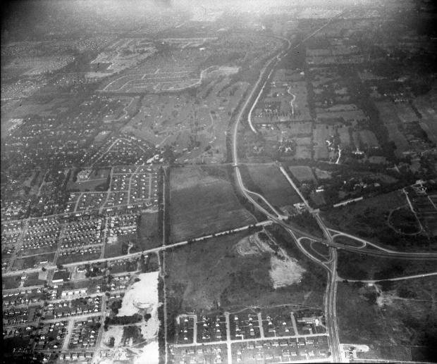
Mystery Foto #5 Solved: A 1950 aerial over the Northern State Parkway from the Cradle of Aviation Archives
The Cradle of Aviation challenged you to solve this final Mystery Foto of the month.
Answers to Mystery Foto questions:
- Identify:
-Location and orientation of the photographer
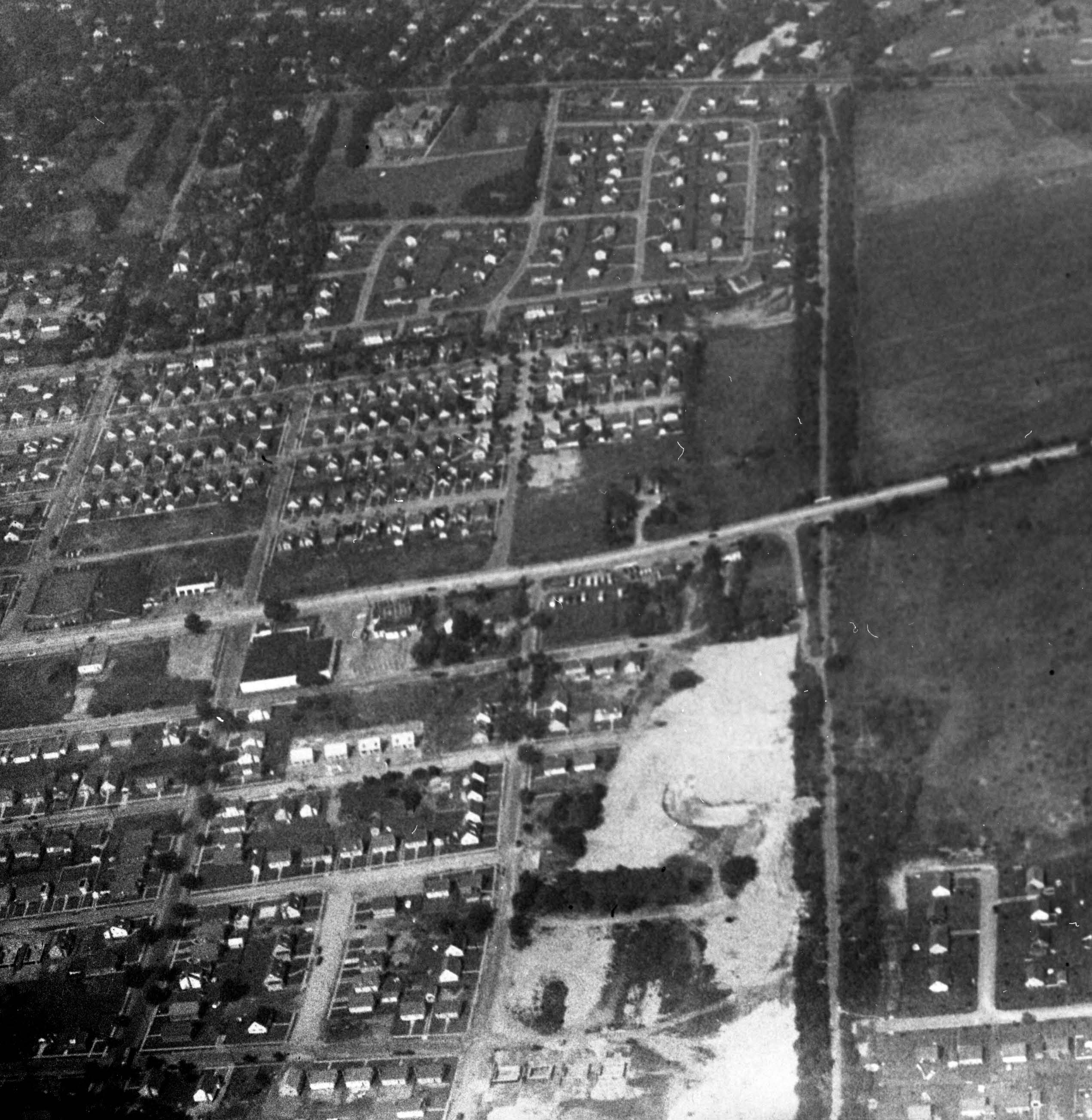
Over the Carle Place/Mineola borderline looking north to East Williston with a flook at the "Objector's Bend" of the Northern State Parkway.
-Location of the Motor Parkway and its structures
-Major roads and parkways
See below Comments from Art Kleiner and Brian McCarthy. Great job!
-Golf course
Wheatley Hills Golf Club, East Williston
- What was the date of the Mystery Foto? Provide a rationale.
September 18, 1950. Rationale: The Meadowbrook Parkway had not been built (see the lower right corner). The dating of the housing developments.
Comments (10)
Congrats to Greg O., Art Kleiner, Al Prete, Brian McCarthy, Mark Lanese, Pat Masterson, Steve Lucas, Ken S., Paul Parisi, Ernie, and Frank Feminias for identifying the Mystery Foto questions.
Kudos to Art Kleiner and Brian McCarthy for their great captioned jpegs.
Enjoy,
Howard Kroplick
Close-Ups
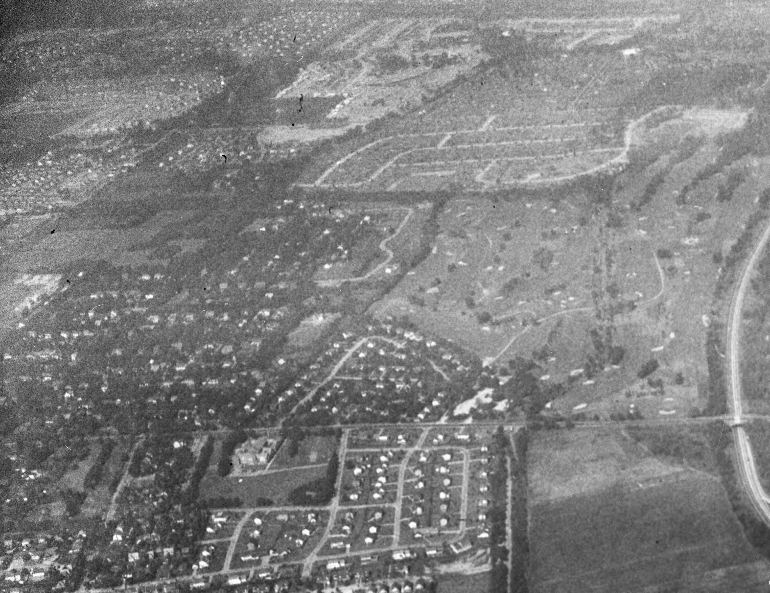
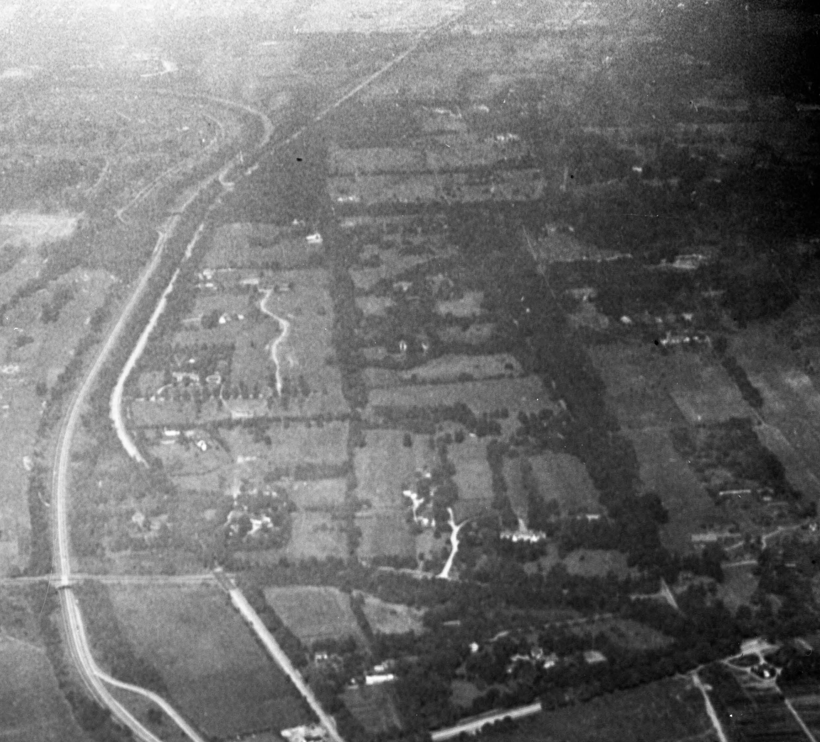
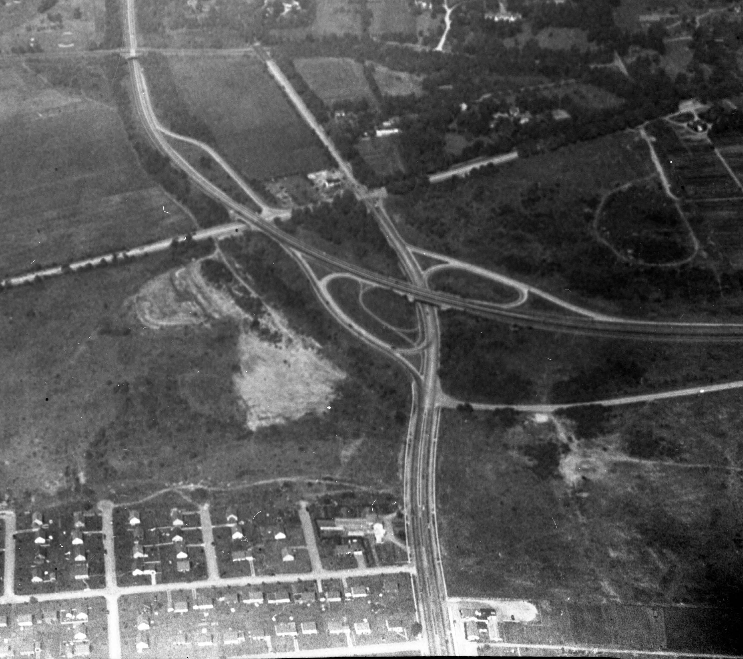

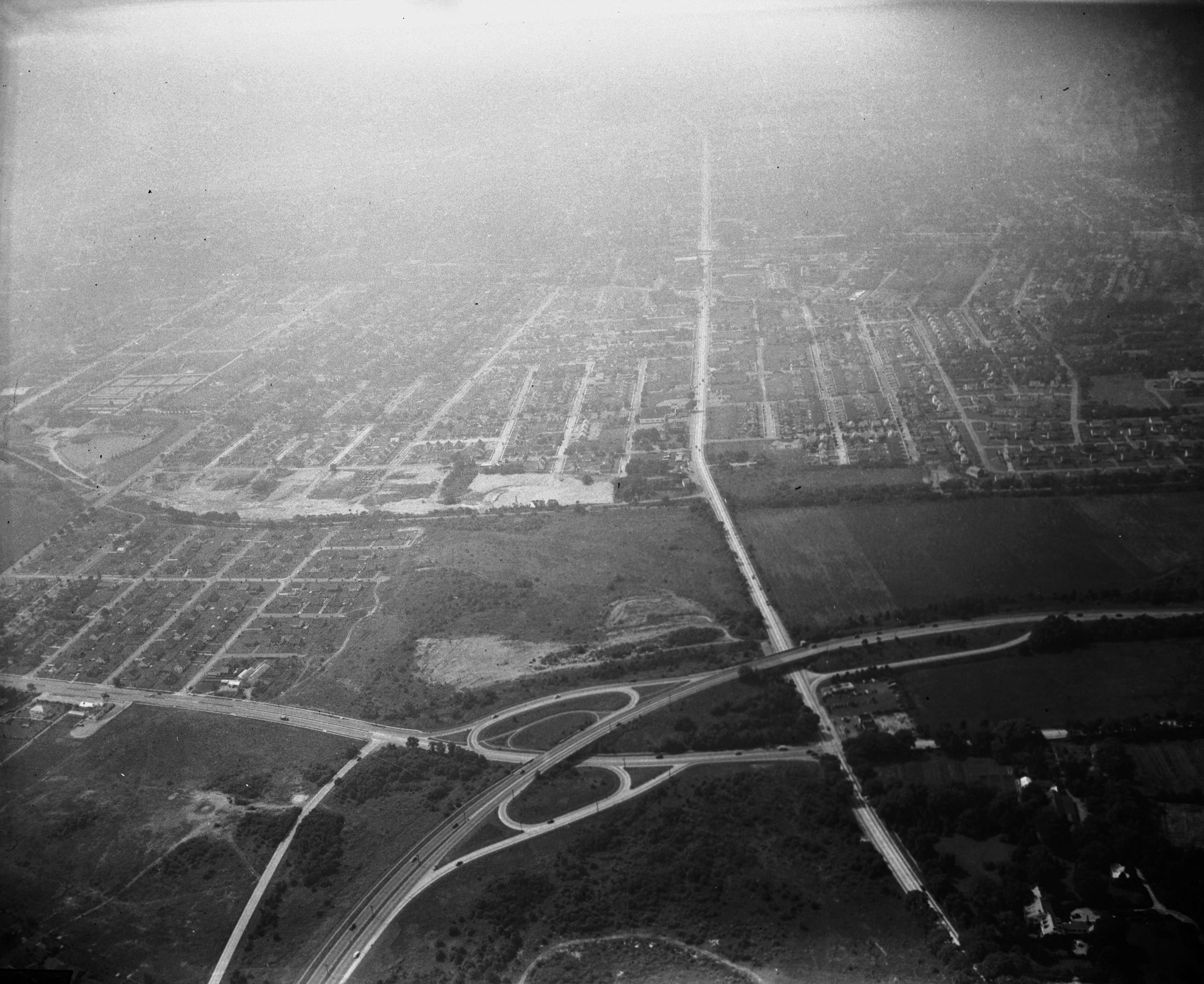
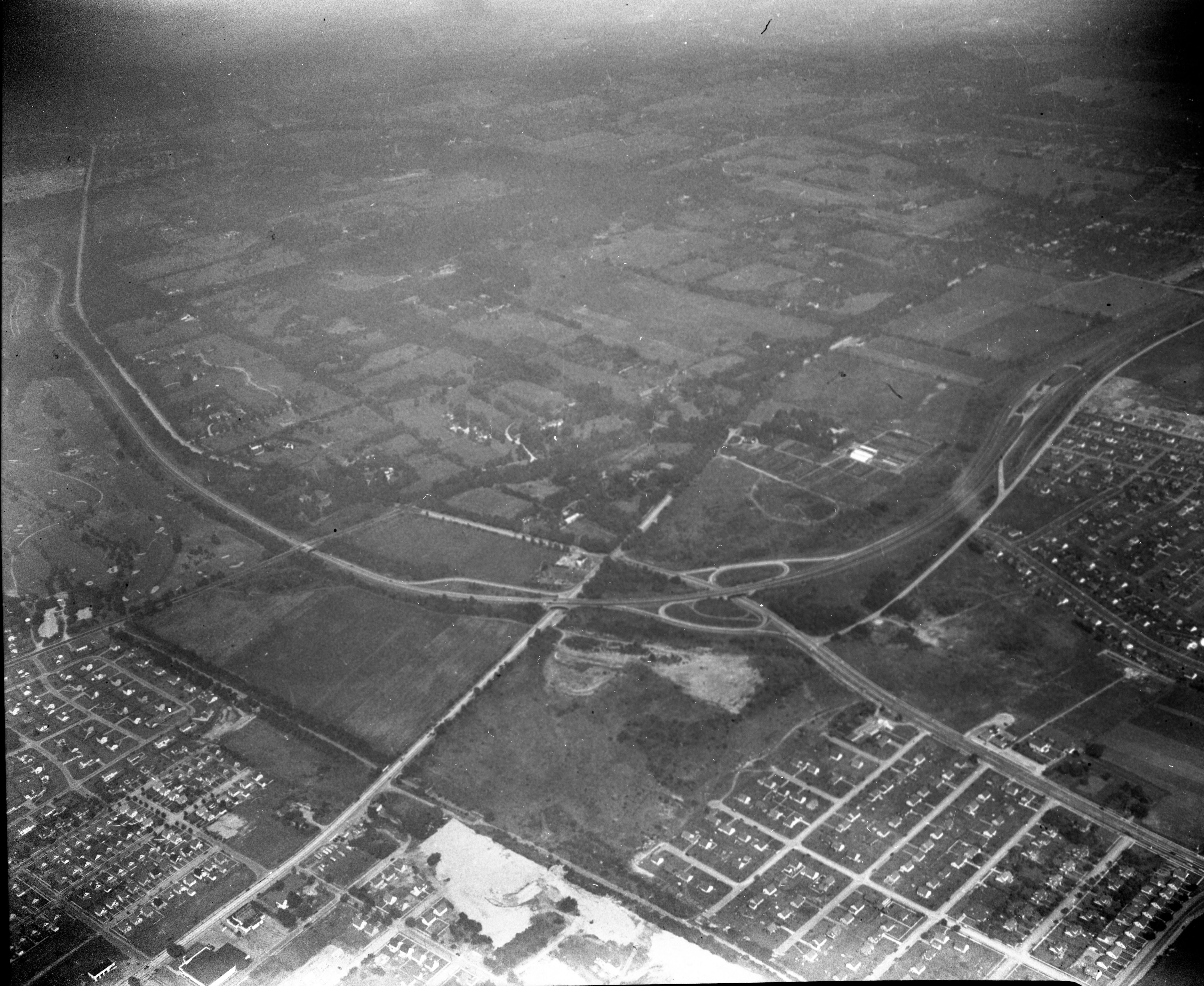
Aerials taken during the same 1950 flight


Comments
Looking North at the ‘Objector’s bend’ section of the Northern State Parkway. The interchange seen in the photo is the exit/entrance ramps of the NSP and Glen Cove Road. The two main horizontal roads are Hillside and Jericho. The LIMP is vertical on the left side. The Jericho Road bridge is still present, but the Hillside and Wheatley Hills Golf course bridge appear to be gone. The Mineola Lodge in the photo is still there to this day as a private home. To make it easy, my date rationale is the photo is 1956 and was taken with the other recent Cradle of Aviation aerial mystery photos.
Looking north over East Williston and Williston Park.
Motor Parkway south down the middle and north of Hillside Ave. into the Wheatley Hills Golf Club.
Glen Cove Road, Northern State Parkway, Hillside Avenue, Motor Parkway
Wheatley Hills Golf Club
Late 40, early 50s. Richard Robbin’s estate had already been layed out with streets but no homes.
Location: Carle Place/Mineola. The photographer is looking north.
Motor Parkway: Lower half of the Foto, about one-third of the way from the left edge. It runs north-south (vertically). The Mineola Lodge (still standing as 284 Rudolf Road) and the ramp and bridge to/from/under Jericho Tpke. can be seen.
Roads: Hillside Avenue, Jericho Turnpike, Glen Cove Road, and the Northern State Parkway. No Meadowbrook Parkway yet.
Golf course: Wheatley Hills.
Date: I’d say 1940, because the LIMP can’t be seen on the golf course, so the roadway must have been removed.
*Area & Direction: viewing north over Mineola, East Williston, Roslyn.
Remaining answers on the marked map attached. Based on the 1950 LRV aerial, say the date of the mystery foto is around 1950. The junction of the Northern State & Meadowbrook Pkwys doesn’t exist yet, not until 1956.
The photographer was over Carle Place near the Mineola border. The view is looking north. Jericho Tpke. bridge over LIMP and the Mineola toll house and the Hillside Ave. bridge are visible. Can’t make out if the farmway bridge and Roslyn Road bridge have been demolished yet. The LIRR bridge would still be there, but not visible. Northern State Pkwy. and Guinea Woods Rd. running parallel north/south and Hillside Ave. and Jericho Tpke. both running east/west. LIMP made it’s curves through Wheatley golf course and heads south through Mineola and Carle Place. The Roslyn Country Club home development behind the golf course was built mostly in 1949. The roads are clearly visible,but I can’t see any houses. Best guess when this picture was taken would be 1949 -1951.
I believe the photographer as over the Roosevelt Field area, looking North. E see the Northern State Parkway interchange with Jericho and the Meadowbrook. The Wheatley Golf Course is near the top of the picture. The Motor Parkway comes South from the golf course, crossing Hillside Ave. and then Jericho. The Motor Parkway entrance to Jericho is visible, and also possibly the Roslyn Lodge.
The photographer was over Mineola looking north toward East Williston. The LIMP is just to the left of center running north/south with the most visible structure being the bridge under Jericho Turnpike. Other structures would have been the Mineola “Toll Lodge”, bridge over Hillside Avenue (E. Williston Ave.), Wheatley Hills golfway bridge, Robbins Lane farmway bridge, Roslyn Road bridge and Roslyn Lodge, LIRR bridge and Willis Avenue bridge. Additional major roads include Glen Cove Road, Northern State Parkway and possibly I. U. Willets Road. The golf course is Wheatley Hills. It appears that the Hillside Avenue bridge has already been demolished, which I believe happened in 1940, so I’ll guess 1940 for the date.
Mystery photo #5 is where the Northern State Parkway crosses Glen Cove Rd. The roadway going left to right is Rt 25/Jericho Tpke. The camera is facing north and the golf course in the distance is North Hills Country Club. The Vanderbilt Hwy is at the right edge of the group of houses and passes under Jericho Tpke. I see my mom’s house in the photo and it was built in 1952 so my guess as to the year of the photo is 1953.
Photographer facing north
The LIMP runs north and south from th bottom of the photo next to the white portion (possible sand pits) up the the golf course. There is an underpass and a ramp to the LIMP
Northern state pkwy, meadowbrook pkwy, glen cove rd hillside ave. Jericho tpke
Wheatley hills gc
1957 since the Meadowbrook was completed in the fall of 1956
-Location and orientation of the photographer
Looking North over Westbury / Westbury Road and Glen Cove Road
-Location of the Motor Parkway and its structures
Enters the picture bottom center. Bridge over Jericho Turnpike clearly visible, not so much over E Williston Ave or the golf course.
Road to the Jericho Turnpike Lodge is seen.
-Major roads and parkways
Jericho Turnpike and E Williston Ave cut righ to left center
Glen Cove Road top to bottom
NSP snakes in center right to middle top
-Golf course
Currently the Wheatley Hills Golf Club. Originally the William Titus farm a farm bridge was built over the LIMP. Became a golf course in 1913 as the Midland Golf Club.
https://www.vanderbiltcupraces.com/blog/article/long_island_motor_parkway_bridge_series_25_wheatley_hills_golfway_bridge_in
-What was the date of the Mystery Foto? Provide a rationale.
Between 1934 to 1958. The LIE made it to Glen Cove Road in ‘58 which sets the latest date, actually earlier sined that is the date of opening and no construction is evident. The route of the Northern State Parkway was extended around “Objectors’ Bend” to EXIT 31 (Glen Cove Road) in Carle Place in 1934 (Wikipedia).
Over Mineola/Carle Place/East Williston looking north on top at the Northern State Parkway/Meadowbrook State Parkway interchange.
Motor Pkwy running vertically about 1/3 from the left. From the north, Wheatley Hills golfway bridge, Hillside Ave parkway bridge, Jericho Tpke highway bridge with Mineola lodge.
MSP/NSP interchange, Hillside Ave/Jericho Tpke interchange, LIMP, Glen Cove Rd.
Wheatley Hills Golf course.
Date could be before the LIE construction in 1958. I don’t see GCP’s exit ramp to access the LIE, at the north end of GCP’s Objector’s Bend at the top of the photo.
I can just make out the road barrier between Jericho Tpke and the Mineola Lodge in the last 1950 aerial. And the LIMP is more clearly seen through the golf course.
I was curious about the street that branches east from Glen Cove Road just south of the Northern State. Looking at a modern map, I see that it must be Asbury Avenue, which no longer connects with Glen Cove Road due to the presence of the Meadowbrook.
Yes, Al. I remember driving through Asbury Ave and it’s construction is similar to the original Northern State Pkwy. Knew I was parallel with the Northern State, and figured it was a service Rd.
Al, Brian, Regarding Asbury Ave. I think that the original east bound entrance to Northern State Pky from Glen Cove Rd. was from Asbury Ave. And, that changed with the building of the Meadowbrook Parkway thru that area. The present day eastbound entrance from Glen Cove Rd. to the Northern State is in the same alignment with Asbury Ave. The western terminus of Asbury today is at Jamaica Blvd. Once the snow clears, going to check if there are any concrete remains west of the end of Asbury Rd.
Your right Al. The map below shows the east ramp from Asbury. This would be just about opposite of today’s Willow St.
Now I just realized Howard’s last NE aerial shows the former alignment perfectly. So more like opposite of the ball field between Jamaica and Willow.