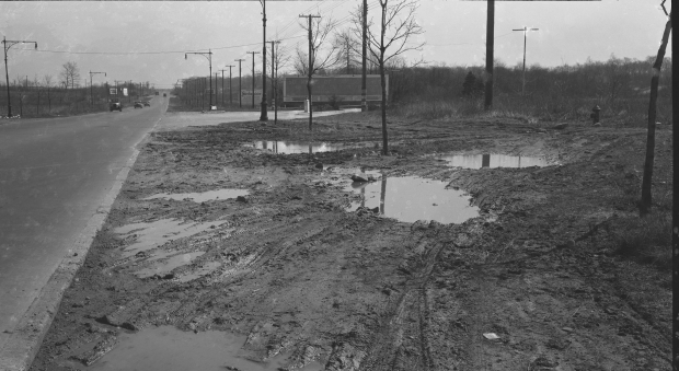
Updated: Mystery Foto #40 Solved: A Historic 1938 Ground-Level View of the Western Terminus in Fresh Meadows
Did you solve this weekend's historic Mystery Foto?
Answers to the Mystery Foto questions:
- Identify the exact location of the Mystery Foto and the orientation of the photographer
Horace Harding Boulevard west of the Western Terminus of the Long Island Motor Parkway in Fresh Meadows, Queens. The photographer was looking east.
- Why is this Mystery Foto a historic photo?
To my knowledge, this is the only known full-view of the Western Terminus entrance at Nassau Boulevard (Horace Harding Boulevard).
- What is the copy on the two large billboards and what was being advertised?
The large billboard was promoting the 50 miles of the Motor Parkway. The Sterlingshire billboard was promoting a housing development built by United Associates.
- What is the approximate date of the Foto? Provide a rationale.
The photo was dated April 11, 1938, six days before the Motor Parkway officially closed. Several date hints in the photos were the automobiles in the background and the possibility that the signage was being removed.
Comments (10)
Congrats to Greg O., Mitch Kaften, Brian McCarthy, Roy W. Warner, Sam Berliner III, Steve Lucas, Ernie and Al W for correctly identifying the Western Terminus in Queens.
Kudos to Greg O. and Brian McCarthy for submitting wonderful jpegs documenting the Mystery Foto.
Enjoy,
Howard Kroplick
The Mystery Foto was dated April 11, 1938. Six days later, the Long Island Motor Parkway would officially closed on Sunday, April 17, 1938.
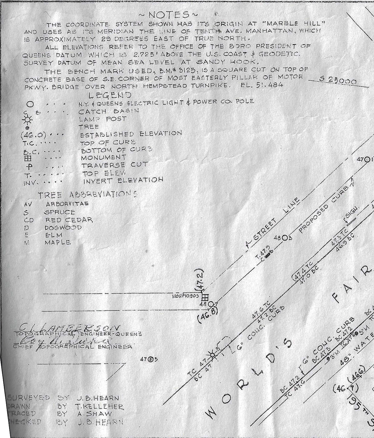
May 10, 1939 Survey of the Western Terminus
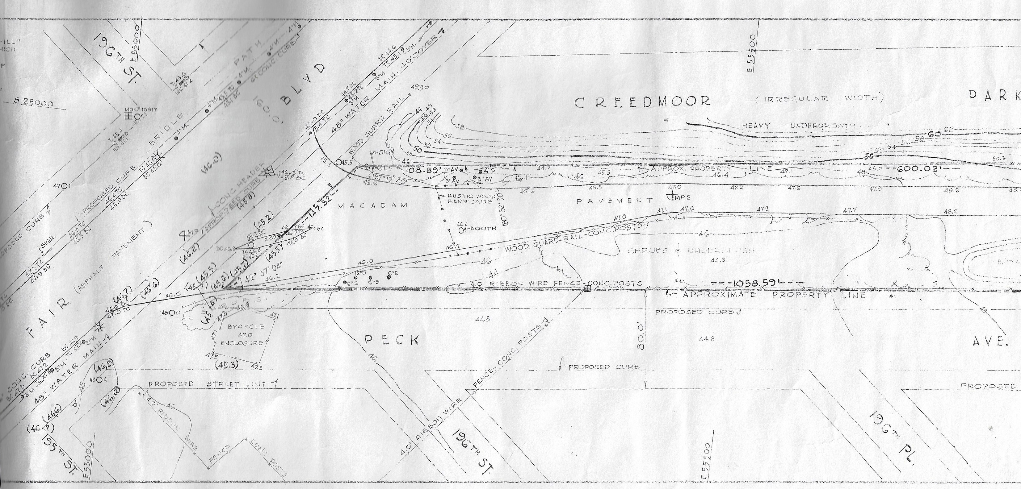
Note the survey indicates the water main line.
Close-Ups
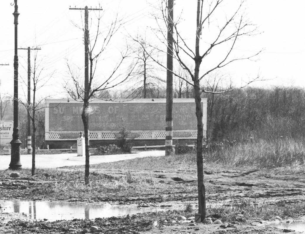
The billboard reads:
50 MILES OF.........
SPEED LIMIT ....MILES PER HOUR
ADMISSION
Note the center island with a lit pedestal with the signage:
SLOW
KEEP
RIGHT
Note the color coding of the telephone poles at the entrance.
The Motor Parkway can be seen on the far right.
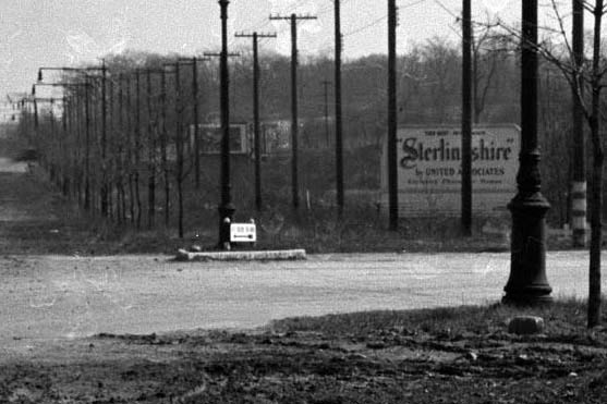
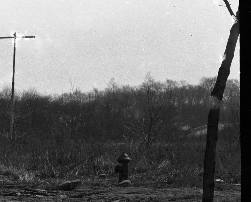
Billboard reads:
"Sterlingshire" by United Associates


The hydrant was far off the road...likely to allow for future expansion.
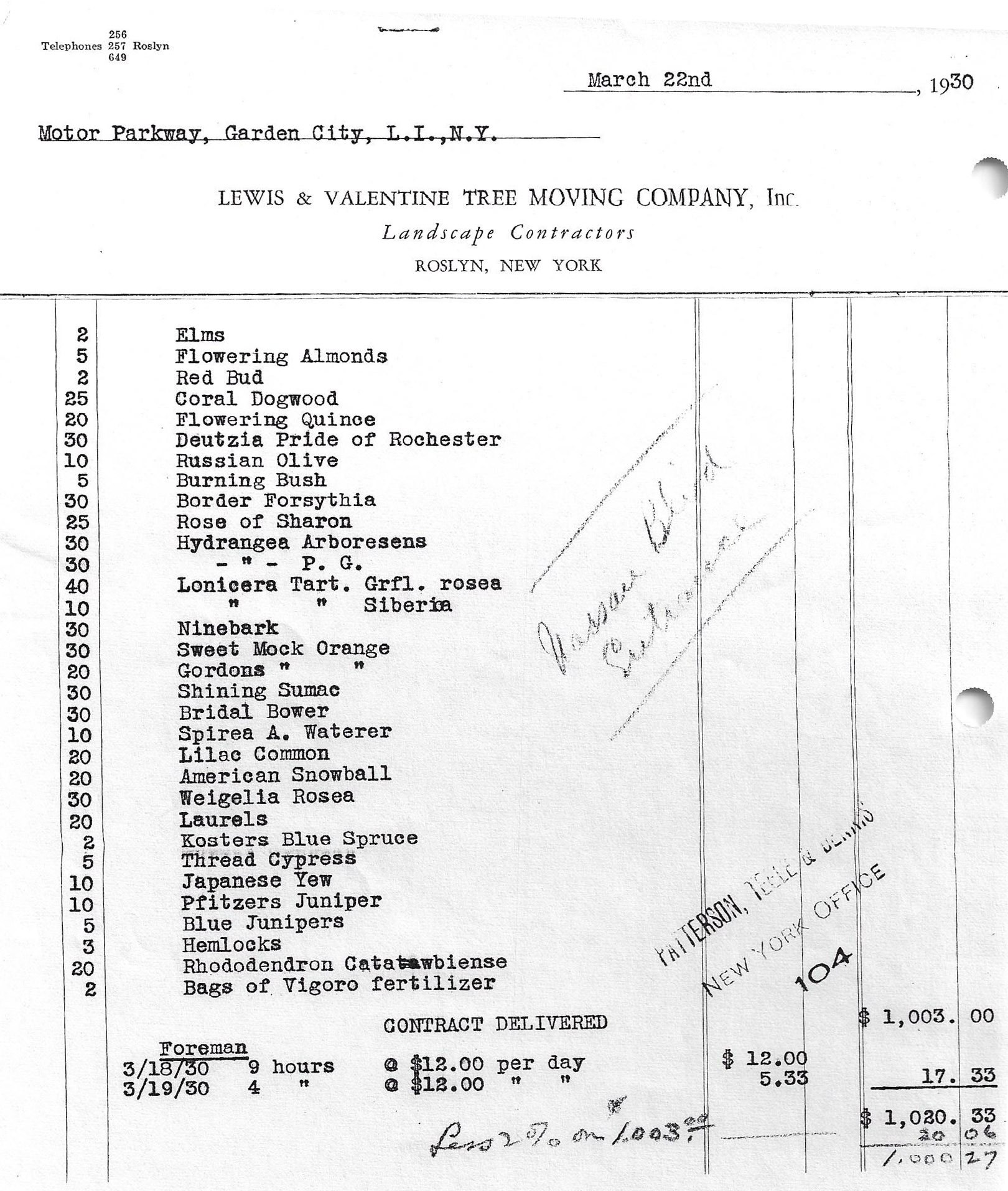
Western Terminus Documents from the Al Velocci Collection
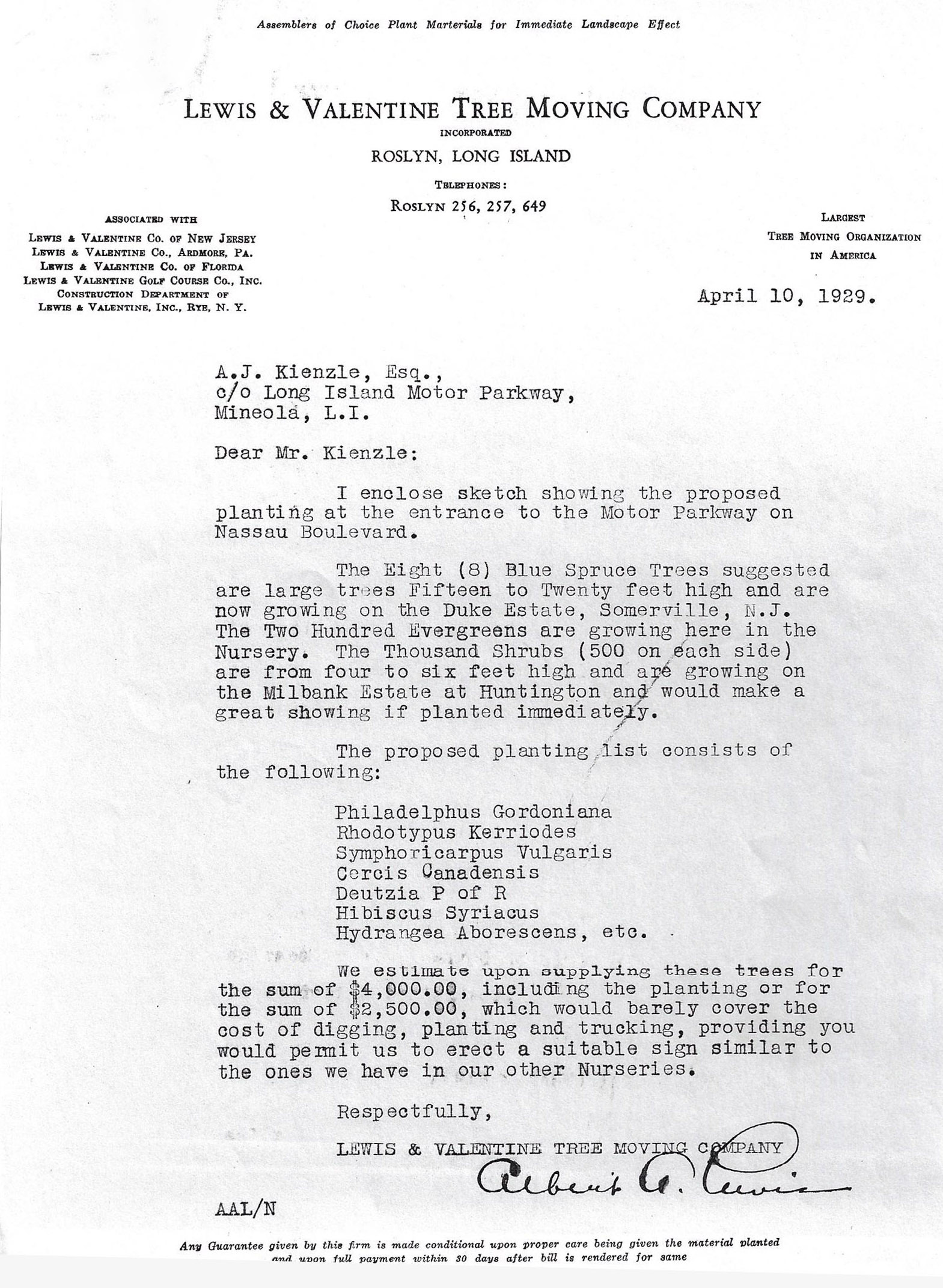
Proposed 1929 planting at "the entrance to the Motor Parkway on Nassau Boulevard" by Lewis & Valentine Tree Moving Company of Roslyn. t
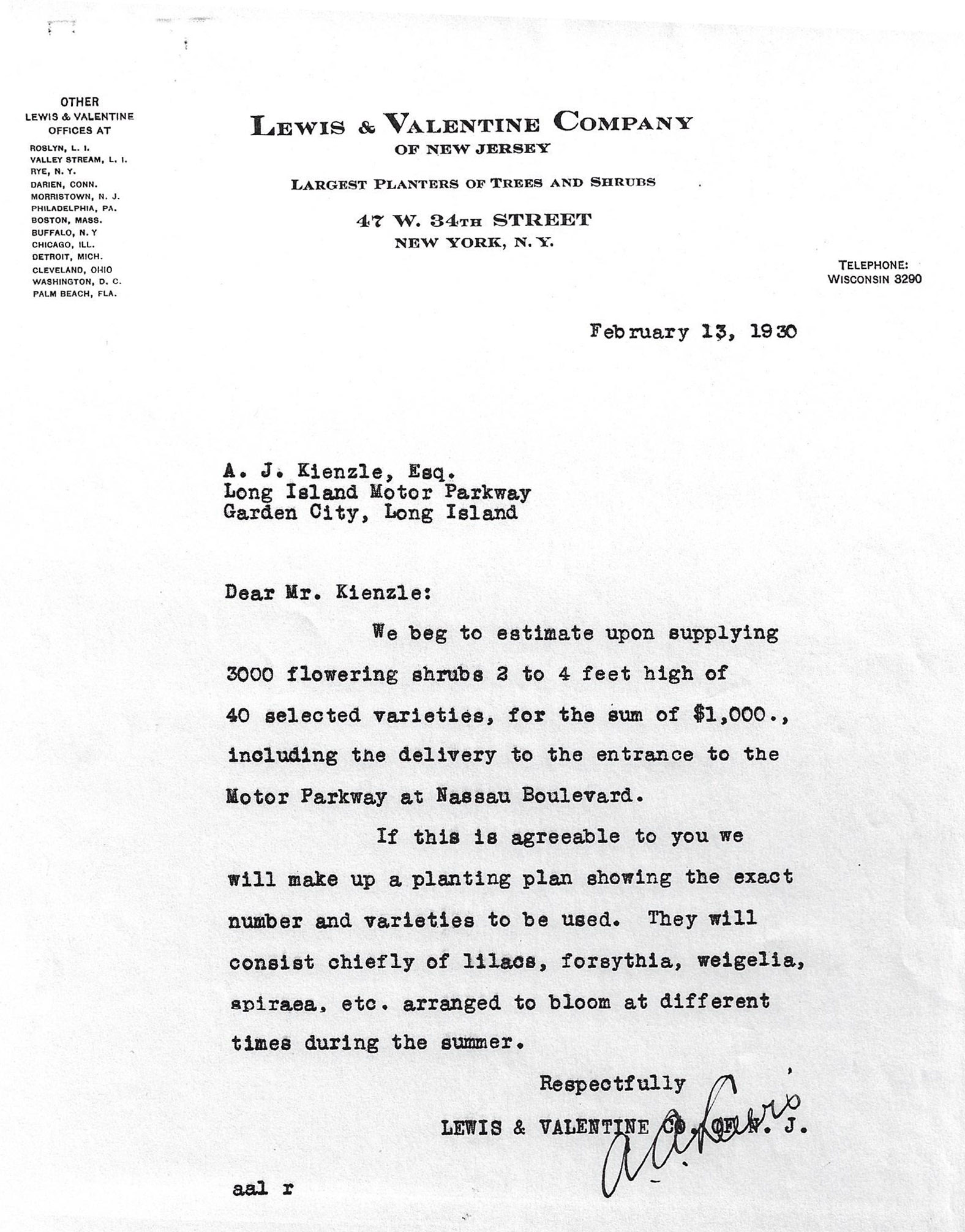
1930 proposal from Lewis & Valentine Company
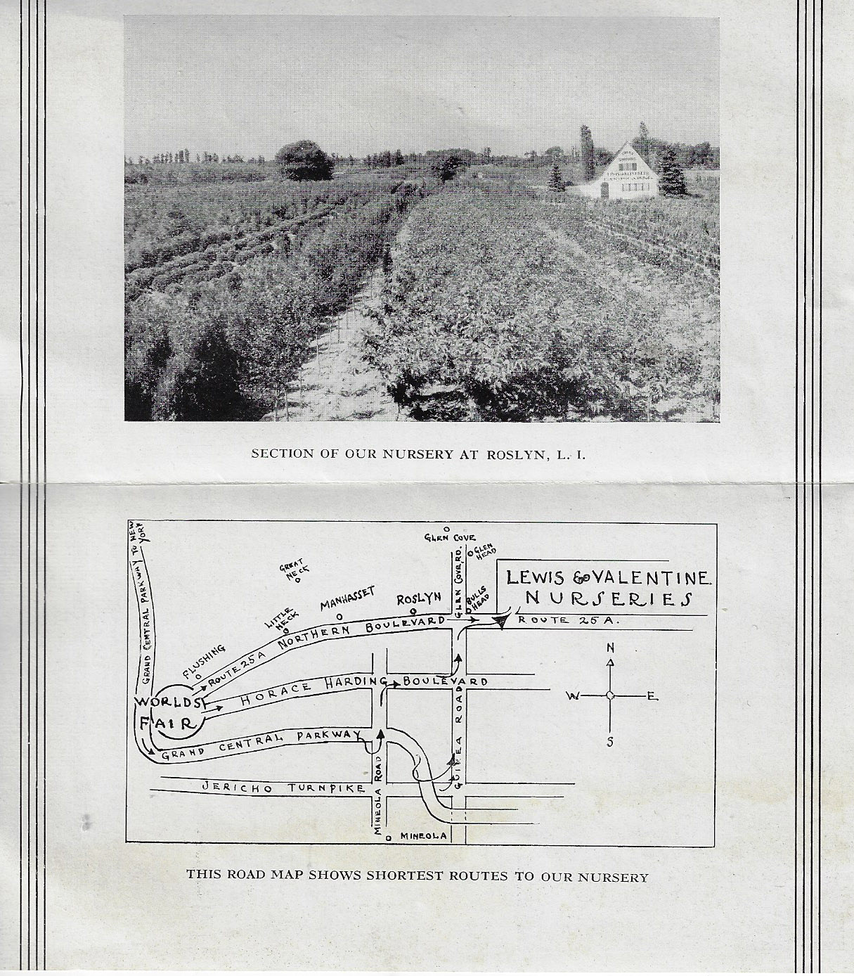
The Lewis & Valentine Nurseries were located adjacent to the former location of Bull's Head Hotel on Northern Boulevard, now considered Greenvale.
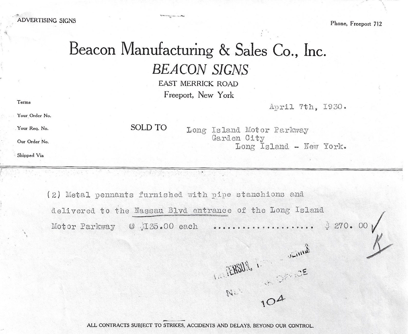
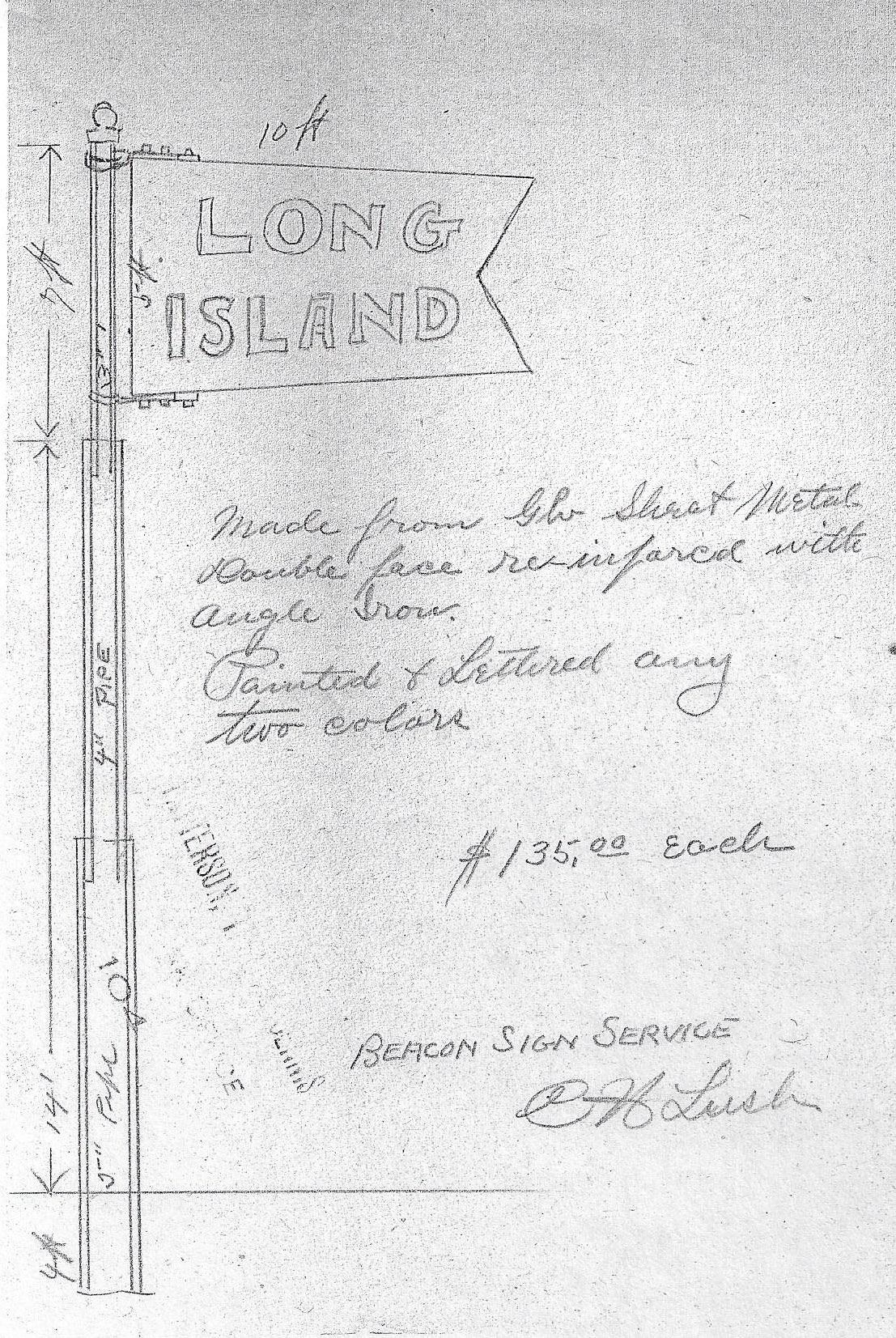
1930 Metal Pennants at the Western Terminus
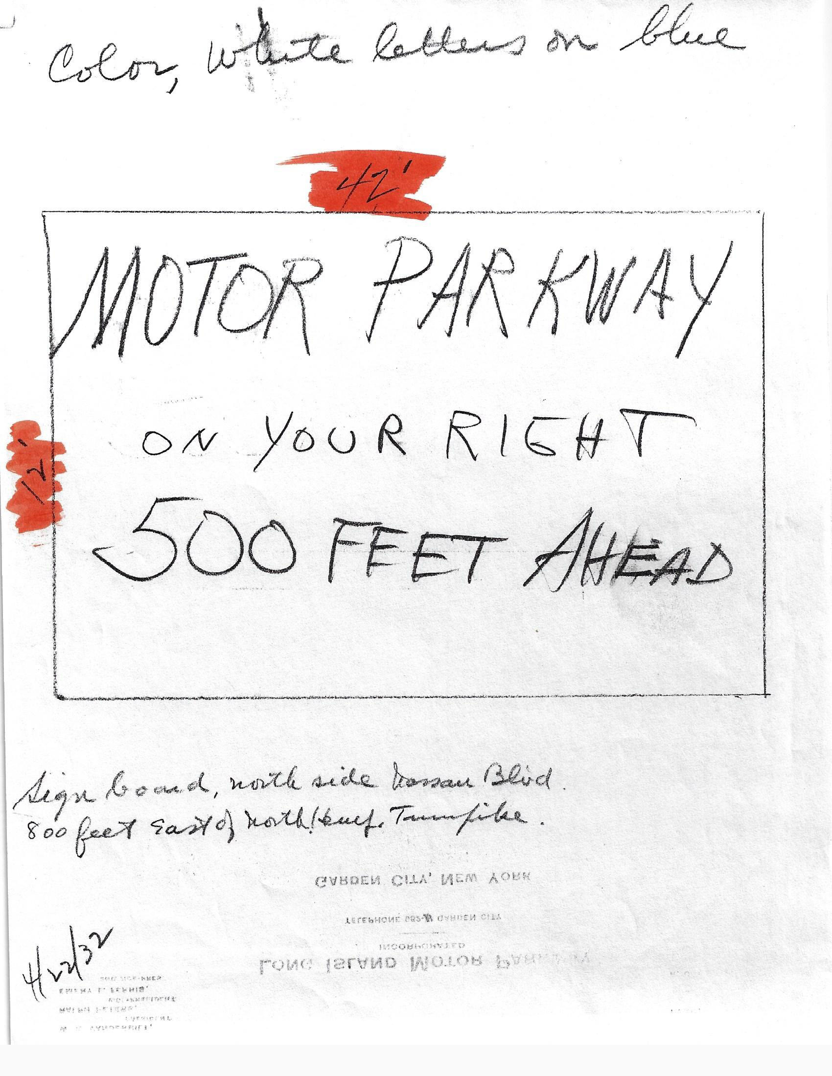
1932 sign copy 500 feet west of the Motor Parkway entrance on north side of Nassau Boulevard.
ADDITIONAL INFORMATION FROM KLEINER'S KORNER BEGINS HERE
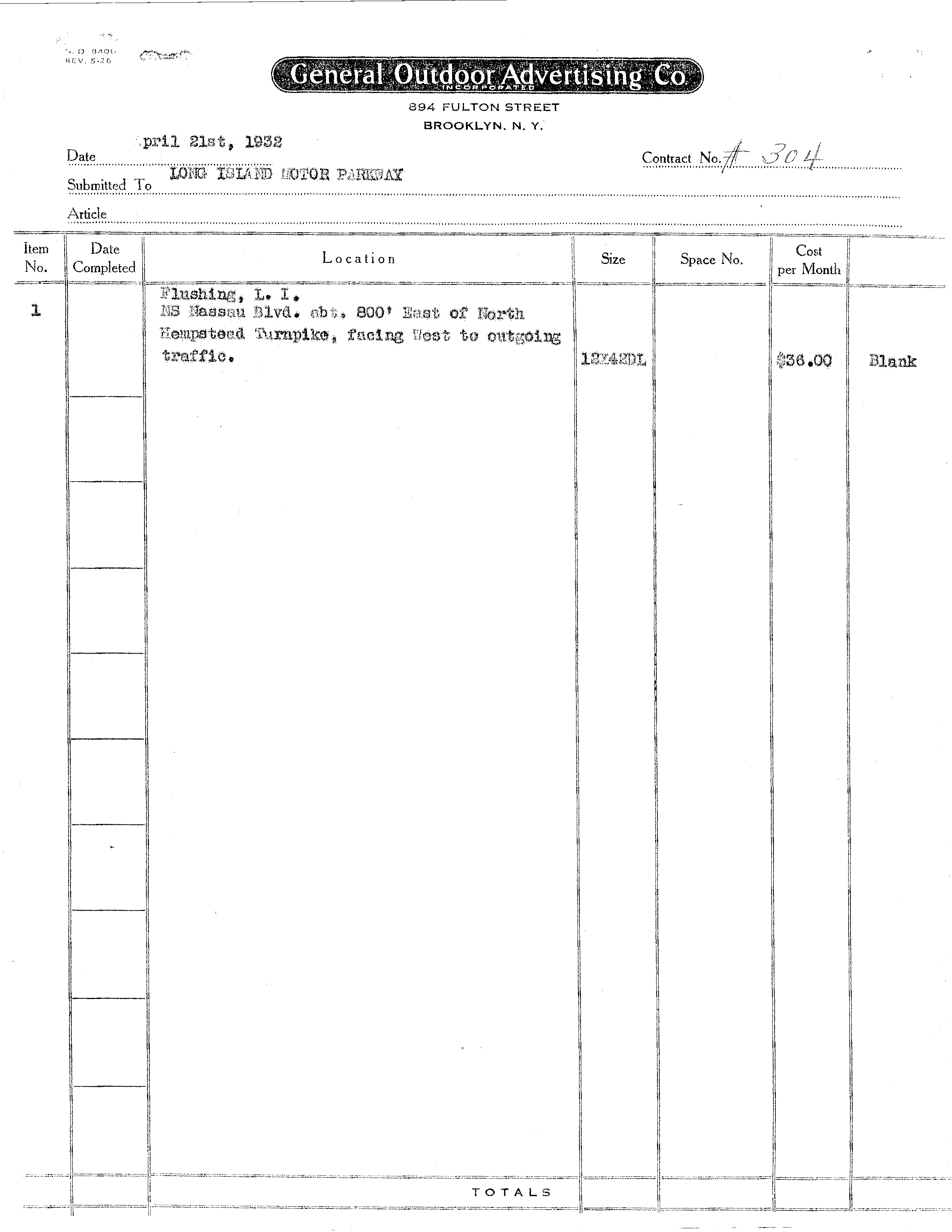
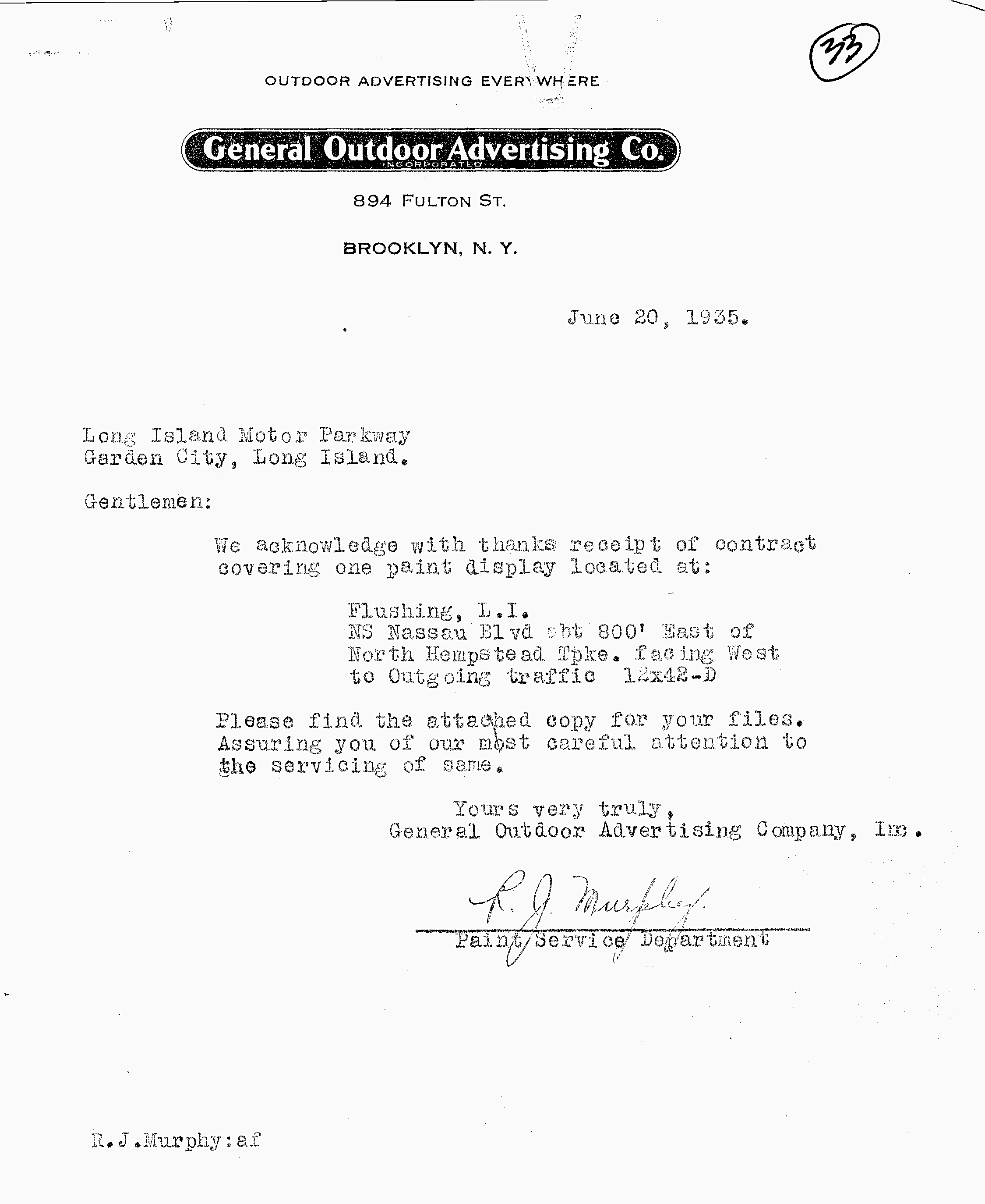
Approval for the Above SIgn: Contract from the General Outdoor Advertising Co. to the Long Island Motor Parkway for the sign north of Nassau Boulevard. Indicates sign should be placed "west to outgoing traffic" and the cost of $36 (presumably per month).
(All documentation in this section is from the Vanderbilt Museum, Centerport)
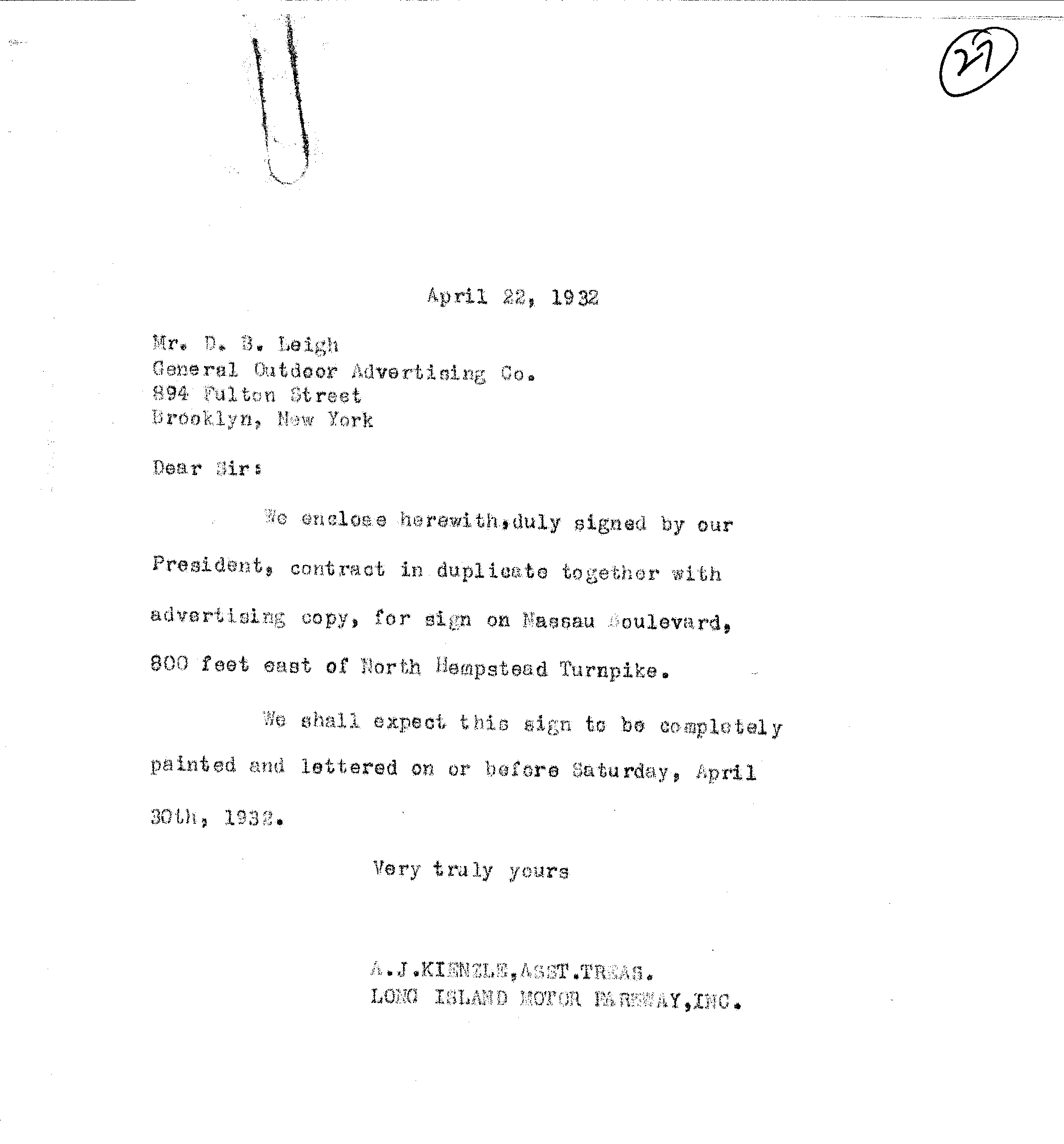
Approval given by A.J. Kienzle with a date of completion on or before April 30.
A Price Reduction in 1935
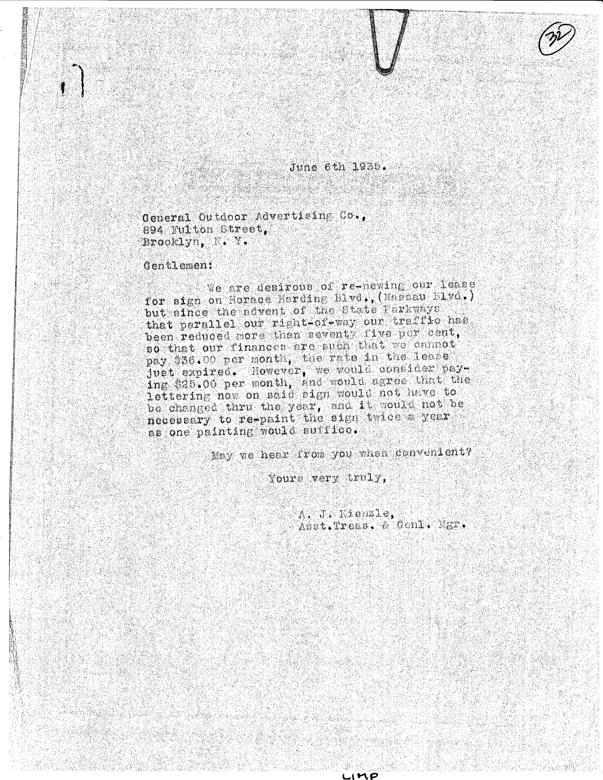
Kienzle indicated the parkway would not be able to pay the $36 fee per month due to lower volume (75% less!) resulting from the building of the "State Parkways".
General Outdoor Advertising must have agreed to a reduced rate with certain limitations.
Additional Signage with Pricing
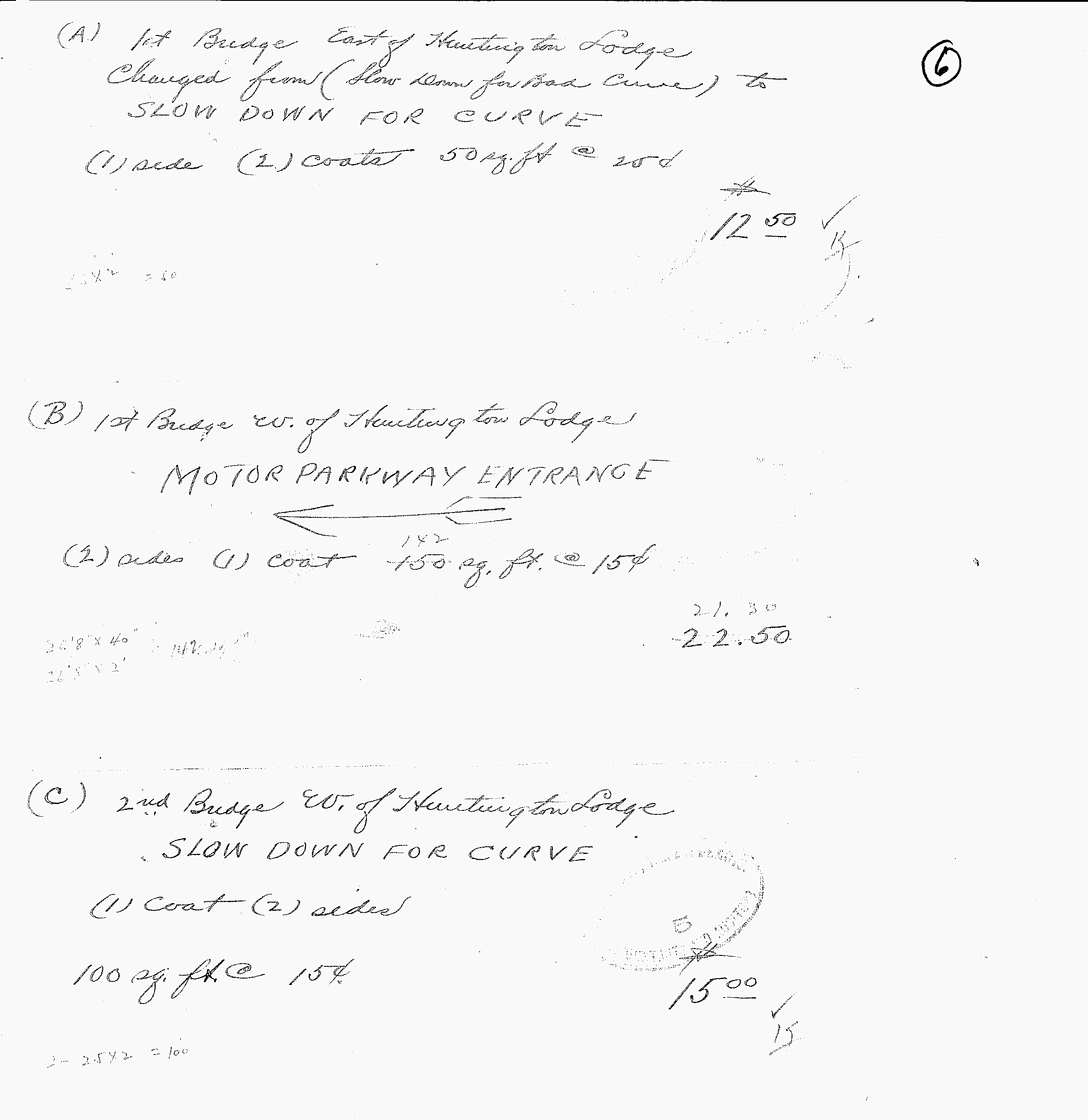
Bridges east and west of the Huntington Lodge
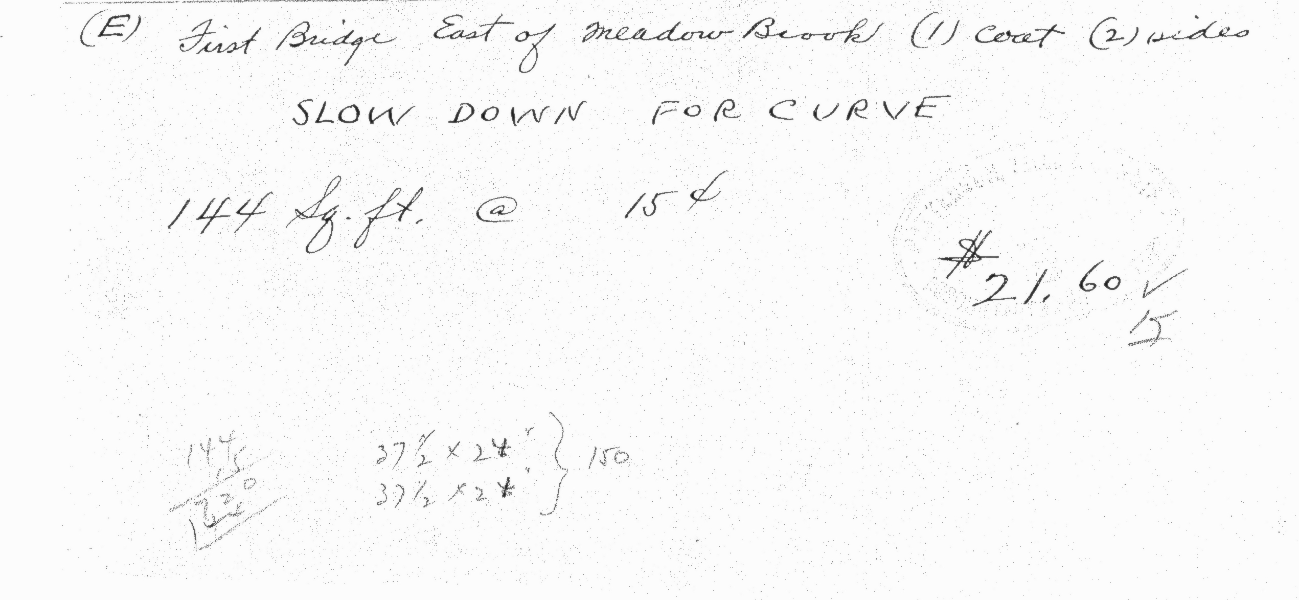
First bridge east of MeadowBrook Lodge
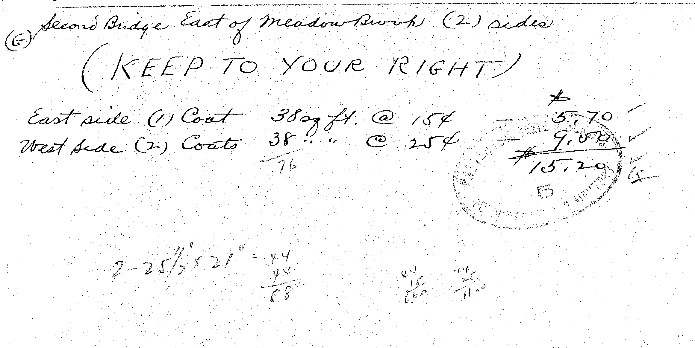
Second bridge east of MeadowBrook Lodge
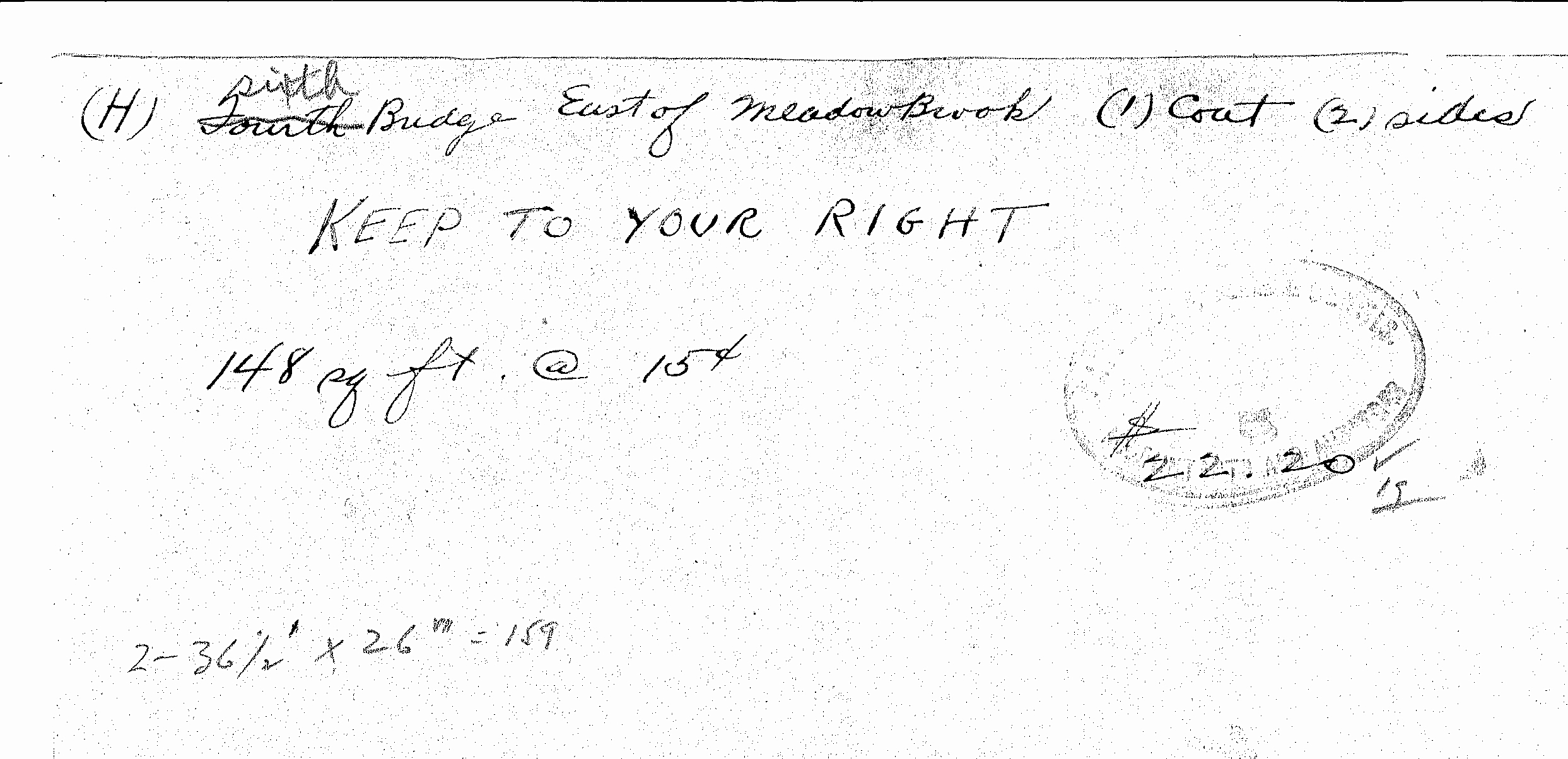
Sixth bridge (originally fourth) east of Meadowbrook Lodge
Let's try to find the exact locations and pictures of these signs!!!


Comments
Wow! Just wow! What a photo! Where did this come from?
The western LIMP terminus looking East Down Horace Harding Blvd in Fresh Meadows. The closer, larger of the two signs is the LIMP entrance sign “50 miles of….” I’d assume this sign was repainted and changed many times, but while the lattice and frame of the billboard are the same as the McCamish plow photos, the wording and artwork is different.
Historic for a few reasons. First, other than the McCamish photos, there really haven’t been any ground level photos of the Fresh Meadows entrance and sign. Second, this is showing an entrance that I know I’ve never seen since I believe this to be within a year of the LIMP closure.
The copy of the smaller billboard clues us in on the date.
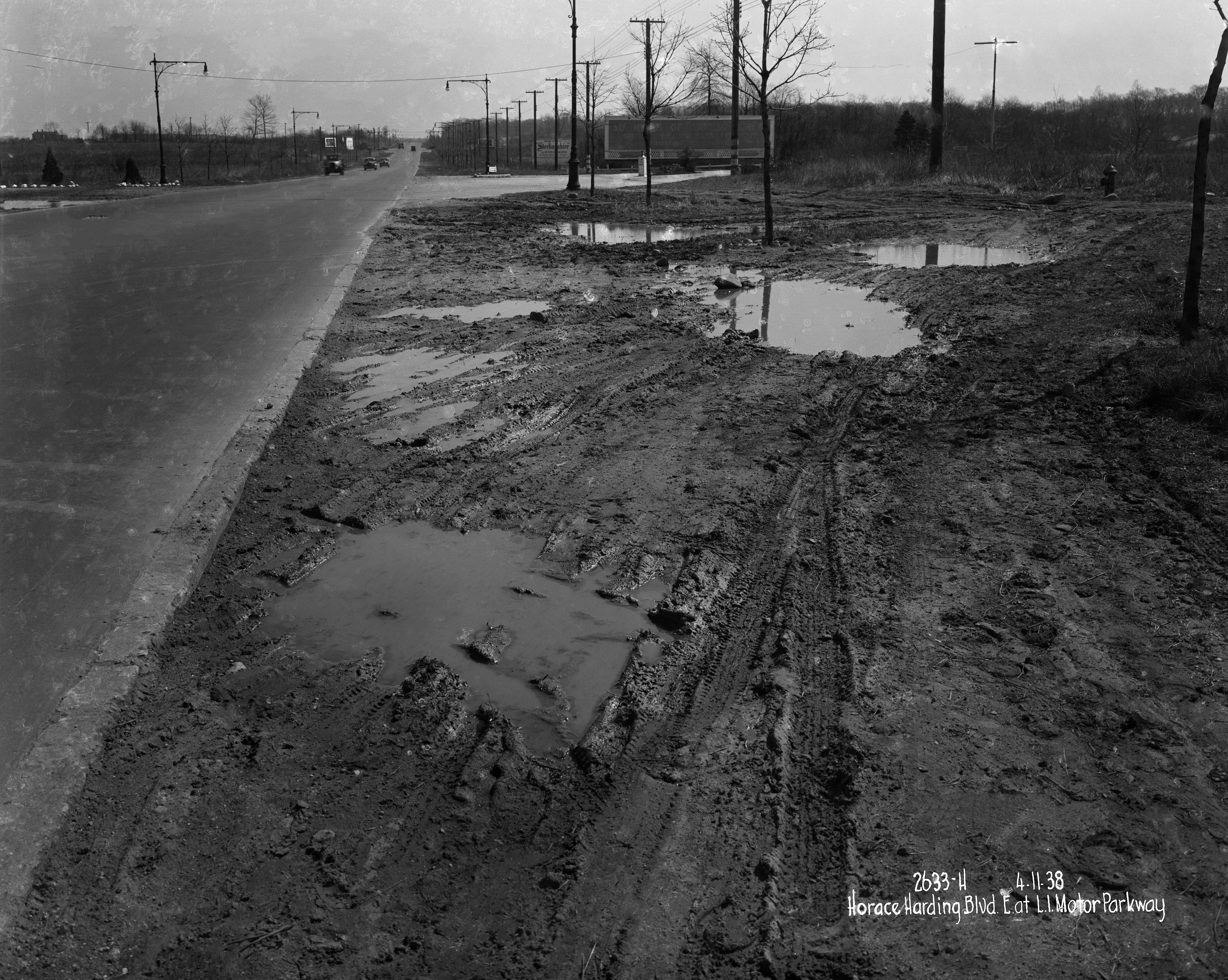
The billboard was advertising an new housing development called Sterlingshire built facing the Grand Central Parkway at Hollis Court Blvd close by. I spotted a Brooklyn Eagle article from Feb 19, 1939 stating that after some unsettled weather around Lincoln’s Birthday, sales were good. It also states that the winter was fairly mild. In the photo, we see no foliage, damp muddy ground and an overall winter ‘feel’ so it may be safe to assume this may have been taken around the time of the article- Feb 1939
I found a photo from a Jan 2nd 1938 Brooklyn Daily Eagle article describing the Sterlingshire homes and a photo of what I believe to be the model home. On Google Earth, I started a virtual ‘driving tour’ of the neighborhood to possibly locate a home as original as possible. The Sterlingshire neighborhood is located just East of Hollis Ct. Blvd on the North side of the Grand Central. I did come across 2 homes on 212th that are very similar to the 1938 photo, but not exact. Unlike later developments, homes were individually designed and have since been heavily modified in the last 80 years, so finding the exact home from the newspaper article may prove to be impossible.
For those interested in looking through the neighborhood on your own, I have circled the area below on a Google Earth screen grab in which the Sterlingshire homes were built.
Here’s my guess: Nassau Boulevard entrance to the LIMP, facing east on Nassau (later Horace Harding) Boulevard. The western-most entrance. In the distance is the crossing of Queens Road, or Hollis Court Blvd. It’s historic (to me) because it’s the first time I’ve seen a full photo of this entrance. One of the billboards advertises the LIMP. I’m not sure what Sterlingshire is but I’ll guess it’s a planned residential community. I can’t guess the year, but I’d say it’s the early 30s or at latest 1938, the year the LIMP closed. In the 40s there was a rudimentary service road being built on Nassau Boulevard and that road isn’t there yet.
*Location & Orientation of Photo - Photographer was standing on the south side of Horace Harding Blvd, facing east capturing the LIMP Western Terminus.
*Historic Significance - I believe the fading copy on the large LIMP sign was the final wording for pkwy users just before the 1938 closing. This is what I can make out - 50 MILES OF SAFE ? ? ? / SPEED LIMIT 55 MILES PER HOUR / ADMISSION 75 CT ? TAX
The other sign beyond “Sterlingshire” by United Associates is likely a real estate advertising.
*Photo date & reasoning - I’ll say 1940 - 1945, educated guess. After looking at the google map, the terminus was more expanded than I thought.
Sign images & info.
The lampposts are those of the City (which are making a comeback today). The right of way appears very wide for Queens, which is consistent with Horace Harding Blvd in the late ‘30s and the ‘40 just before and during the War. Given that I grew up in Fresh Meadows, my hunch is that the view is looking east at or near the old entrance to what was the Motor Parkway. The angle of the intersecting road might have been the gateway road into the Motor Parkway entrance at its terminus in Fresh Meadows, which would have opened in 1926.
South side of Nassau Blvd. (Horace Harding Blvd.) in Black Stump-cum-Kissena Park, Flushing (today’s Fresh Meadows), looking east at the western terminus of the LIMP (with kiosk out of sight to the right), from about today’s 194th Street. Far sign promoted development of what later became Fresh Meadow(s) housing complex; near sign advertised the Parkway. Muddy verge was later paved, tree-lined, and sidewalked. Cars are from the late 30’s. Guessing historic because it’s the only such view and probably taken just about when the LIMP closed on Easter Sunday, 16 Apr 1938. Howzat? Sam, III
The photographer is looking east on Horace Harding Blvd. (Nassau Blvd.) in the Fresh
Meadows area. The photo is historic because this is the site of the entrance and western terminus of the LIMP. The large billboard, although in neglected condition, appears to be advertising the LIMP. I can only determine a few words like “50 miles of paved__?___” and “__?___ miles per hour” and “admission 40 cents”. The other sign is advertising “Sterlingshire” by United Associates which might be a housing development or apartment complex. Based on the vehicles and the condition of the LIMP sign and what looks like preparations for the widening of Horace Harding Blvd., I’ll guess the date to be around 1940-1941.
This would appear to be looking to the east at the western entrance to the LIMP along Horace Harding Boulevard. The first bill board with the lattice bottom is announcing the parkway “50 miles.”
Billboard lattice has been documented in these pages here: https://www.vanderbiltcupraces.com/images/blog/107aR.jpg
This is the entrance to the Motor Parkway from Horace Harding Boulevard,looking eastward.It appears to be not long after the parkway’s closing judging from lack of activity or upkeep.The billboards advertised the parkway itself and a pending real estate development locally. Today’s view would feature the LIE in place of The Horace Harding/Nassau Boulevard and St.Francis Prep High School on the near right side. The intersection in the distance is probably Hollis Court Boulevard;it does not appear that Francis Lewis Boulevard has been constructed yet. Time period:1939 approximately
Missed this week’s mystery photo, but an amazing and actual view of the Motor Parkway entrance, as it appeared to motorist heading east on Nassau Blvd (LIE & Peck Av today). This semi-secluded entrance lacked a bigger sign for motorist to engage, and also needing a reduced fare to accommodate all motorists. Thanks Howard for discovering and sharing this gem to all.
This an amazing historical Queens photo
I wrote “because it’s the only such view” but completely forgot to mention my all-too-oft-noted missing pix of the same area taken several years later when the HHB verges were just being paved and planted. I didn’t take those pix (too young) and so SOMEONE other than I must also have them. If I ever find those fool photos, I will be even-more-insufferable on this subject! Sam (the Hyphen-King), III
Top photo: The fire hydrant in the mystery photo appears lined up with the LIMP’s entrance island, but closer to the south side of the island.
Mid photo: Using this parameter, a current Google map search revealed these two hydrants today, located on the south curbside of HHB. I suspect the older, capped-off hydrant on the right, IS the hydrant in the mystery photo.
Bottom photo: A current view of where the photographer was standing in the mystery photo. This current view was taken just inside the HHB south border (blue line), vs the mystery photo view, taken just outside the HHB border. The hydrant can be seen in the current view.
Frank, wow, super analysis. It is likely the water main was planned for a future expansion of Nassau Boulevard. Howard
Agreed. At first I had doubts.
Kleiner’s Korner has provided additional information pertaining to Motor Parkway signage in the main content section of this blog. All courtesy of the Vanderbilt Museum in Centerport.
You definitely nailed it Frank. Thought it was interesting that a hydrant is “nearby ” on Peck Ave, and my imagination got the better of me. History wise, it’s neat that the original one is still there, much less work to cap off than remove entirely.
Fabulous documentation; amazing! Just noticed that “1932 sign copy 500 feet west of the Motor Parkway entrance on north side of Nassau Boulevard” is on the *NORTH* side. Do we have pix of same? Sam, III
To those wondering why the direction signs are on the northside. The City acquired a 160 foot wide ROW for the boulevard to be built to the Nassau County line. The completed roadway seen in the photo is on the northside of the ROW which was built in 1928; The southern part of the ROW was a state of flux with utilities etc. being laid. Hence the signs were put on the northside. The hydrant seen in the photo defines the southern edge or the 160 foot wide ROW. Great detective work by Frank"s updates on the hydrants.
In 1927 A. J. Kienzle, the Parkway’s GM, ordered 5000 toll tickets inscribed, “Nassau Boulevard Lodge” when that was the name of the road. In April 1929 the name was changed to Horace Harding Blvd. Kienzle’s reaction - SOB!!!! He calls Vanderbilt-tells him the news, Willie responds SOB!!!! Vanderbilt calms down, tells Kienzle, “fogedabdit’, no one is to going to call it that!, some day in the future in continues, they are going to change the name of Sixth Ave. to Avenue of the Americas, same thing is going to happen…. keep using the tickets. The frugal Kienzle doesn’t even bother to over stamp the tickets with the new Boulevard name. Those tickets were in use into 1936, when new tickets for this gate were ordered for the first time inscribed “Horace Harding Blvd.” That is why toll tickets inscribed with this name are so rare.
Al, what about “World’s Fair Boulevard” ? Horace Harding Boulevard was officially renamed World’s Fair Boulevard for two years, 1938-1939, commemorating the New York World’s Fair.
Just thought that the bridges that were painted - slow down for curve & keep to your right - were the highway type. Ex: 1st bridge east of Meadowbrook Lodge is Merrick Ave Pkwy Bridge. Merrick Ave is a straight run. So here’s my answers without bridge images ( in case I’m wrong )
One more
Brian- I realize you mentioned East of the Meadowbrook lodge, but for some reason the Clinton bridge always seems to come to my mind first.
First impression of this iconic mystery photo of the Motor Parkway’s western terminus was the lack of signage. Little did I know there was additional signage on the NORTH side of HHB (Nassau Blvd) behind the photo, 500 ft west of the entrance. This sign must have been billboard sized to capture the attention of all eastbound travelers on busy HHB. Someone has this photo. Al’s intricate documentation continues to provide a clearer path of what was back then. Great documentation here by all!
Sorry Brian, I missed your earlier input
Courtesy of this site, matching images for B) & C)
Frank. The sign on the north side of HHB west of the Parkway entrance was billboard size measuring 12’ x 42’
Thanks Al! I didn’t realize the red marks above were highlighting the sign’s dimensions. Now, to locate a photo of that sign. Perhaps in the Queens Borough President’s online library
A May 10, 1939 survey of the Bike Path at the Western Terminus was added to the post
Amazing topographic map Howard! Also including 160 ft wide World’s Fair Blvd as Al posted!! And revealing proposed Peck Av just south of existing Motor Parkway!!! Bases are loaded here. Who’s up to bat? Great stuff!
Fab Fair facts, Frank! Blew it up and look at all the ribbon wire fencing in concrete posts! Bravo! Don’t have my arch./civil eng. handbook handy; what are the symbols along the south side of HHB-cum-WFB - is the fire hydrant one of them? Sam, III
Sam - The “sun” symbol looked electrical but had to look them up. That one is a ceiling mounted light (street light). The other linear circles, with numbers inside I believe, resemble the welded receptacle symbol for electric. The fire hydrant is below
It makes sense. The lamp is directly over Peck Av, but I see no hydrants anywhere in this topo.
I know they were renting bicycles at one point, but why would they put a 47ft Bike Enclosure in the middle of the street, entirely blocking Peck Av?? Perhaps permissible while the Fresh Meadows Grove apartments nearby were being constructed? I dunno! :D
Update: I found the sole hydrant on the curbside
I keep forgetting Peck Av was proposed in the topo. The roadway came after the Bike Enclosure. Time for coffee!
Why the name change from Nassau Blvd. to Horace Harding Blvd ? That story goes back to 1923. That year J. Horace Harding, a NYC banker, headed up a group that donated money to fund a study by the Queens Typographical Bureau to extend Nassau Blvd. to the Nassau County line. In 1924 NYC began the process to make that happen and by 1928 the Motor Parkway was able to access Nassau Blvd. Harding died Jan 4, 1929. In April that year the City Council passed a resolution renaming the road after him since his was the prime reason for it’s being. Today the Queens portion of Route 495 is called the Horace Harding Expressway.
Another typo? Queens T*o*pographical Bureau, more likely. :·) Sam, III
Thanks for noting the hydrant, Frank. Speaking of typos, note the “BYCYCLE ENCLOSURE”! Was one to bicycle by cycle by the enclosure? Sam, III
Sam, if memory serves, I read once that bicycles were rented to travel on the parkway (prohibited by Willie K during operation) to another station by Winchester Blvd. I’m assuming dual bike enclosure stations were in place on both ends of the bike path, so renters could return the bikes for one-way trips. After LIMP closing in 1938, parking stalls were available south of HHB, in the area just south of the entrance island, for renters to park their vehicles.
Western terminus parking stalls in 1938. Courtesy Al Velocci
The two 1930 metal pennants purchased for the Nassau Blvd terminus were HUGE, 5ft. by 10ft. and standing 21 feet high. I see a single pole in the photo above. I wonder where the second pennant was installed?
WOW! Look at Frank’s/Al’s parking stall aerial! Another one I missed. There’s that paved verge on the south side of HHB that I’ve been yammering about all these years! No such on the north side. Sam, III
The “500 Feet Ahead” sign from a damaged negative dated 4-17-34. On bottom of sign one can see the word TICKETS. NHT was 2000+’ west of LIMP, so a sign placed 800’ E of NHT would be more like 1000+’ from the LIMP—false advertising! Note the horseback riders in the unpaved north side HHB, marked as “bridle path” on the survey map.
HHB was never “expanded.” The utility poles define the original 160’ ROW, which was paved in stages starting with the center-most part. A Topo Bureau map from 1945 details the side “service roads” from the main central lanes, just east of the LIMP. The planted trees and the street lights mark the separation. The hydrants align to the utility poles. The service roads were fully implemented adjacent to the Fresh Meadows development as can be seen in 1951 aerials of F.M.
Frank’s suggestion is plausible as the south edge of HHB/LIE-HHE is pretty much the same in Fresh Meadows today as years ago. There are water main manholes in the current south service road in the parking and middle lanes. However, hydrant at right in Google picture is the newer of the two.
Land for Sterlingshire was purchased May 1937 and first homes sold that November at HCB and 212th St. Developer offered 15(!) styles of homes, making the homes seem to be custom built.
David, FANTASTIC PHOTO!!! I hadn’t begun to search for that photo of the sign. I had assumed the north billboard signs were located within the bridle path. Not so as the photo clearly reveals. The ped/bike overpass on the map shows detailed locations where Motor Pkwy/Peck Ave/overpass once resided together. Amazing finds!
This Queens photo sure stirred up a lot of info and discussion!