Mystery Foto #21 Maybe Solved: The Clinton Avenue Motor Parkway Bridge Under Construction in 1909?
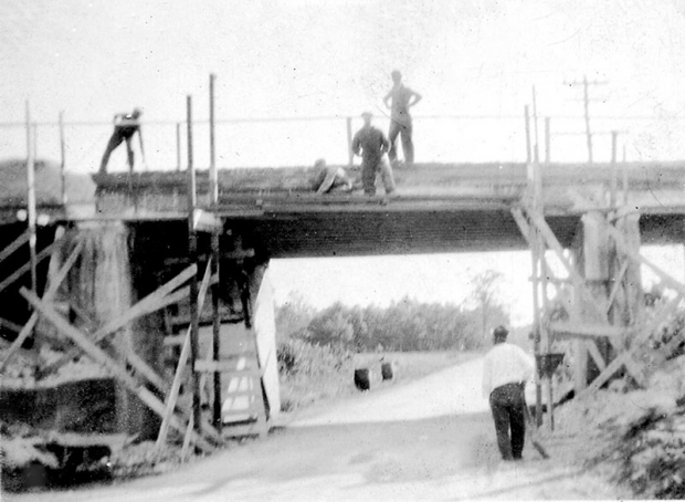
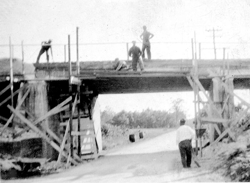
Gordon Bainbridge challenged you to identify this previously unpublished photo of a Motor Parkway Bridge under construction in 1909.
Mystery Foto questions:
- Identify the Motor Parkway bridge. Provide a rationale. Hint: The bridge is a "parkway" bridge (the Motor Parkway is on the top).
The bridge is likely the Clinton Road Motor Parkway Bridge (60% probability-lowered prob. % due to comments). Rationale:
-The bridge appears to be a two-pillar Motor Parkway bridge.
-The photo is from the collection of Gordon Bainbridge, whose grandparents were lodge keepers of the Garden City Lodge.
-The 1909 date.
Other possibilities: Broad Hollow Motor Parkway/Trolley Bridge (1 pillar) and Westbury Avenue Motor Parkway/Trolly Bridge (2-pillars).
- What is the likely orientation of the photographer? Provide a rationale.
The consensus is the photographer was looking north (60% probability). Rationale: The telephones lines on the right. However, the orientation has not been confirmed by ground images or aerials.
Comments (16)
Congrats to Greg O., George Philippides, Steve Lucas and Robert Stambaugh for reaching the same conclusion of the Clinton Avenue Motor Parkway Bridge.
Enjoy,
Howard Kroplick
Close-Up
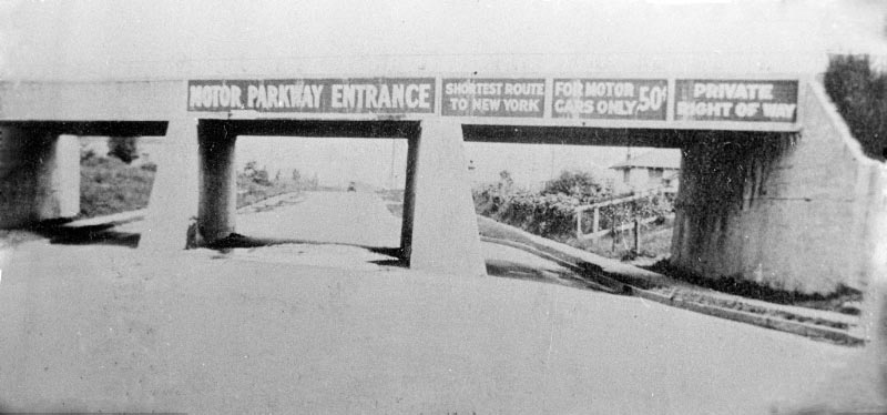
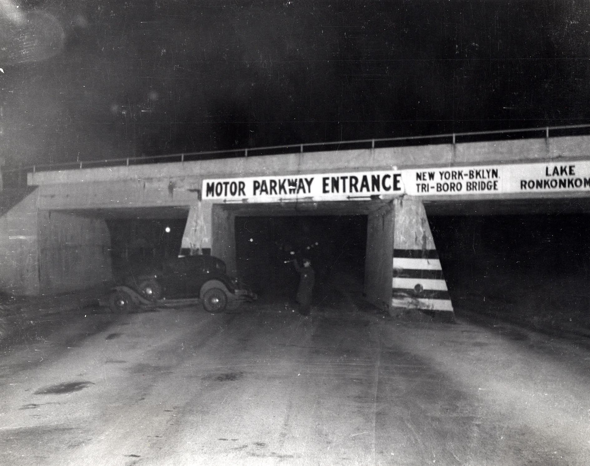
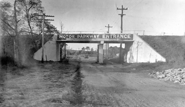
Clinton Road Motor Parkway Bridge
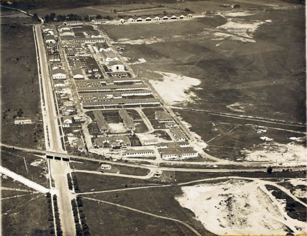
Circa 1926
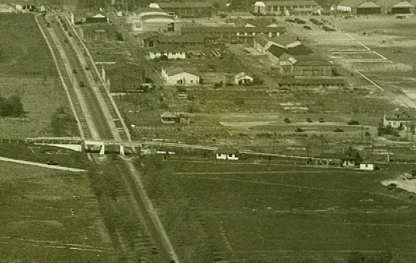
Circa 1927
Looking north. Circa 1930s. Is that a telephone pole seen through the pillars?
Looking south. Circa 1930s. Courtesy of Ron Ridolf.
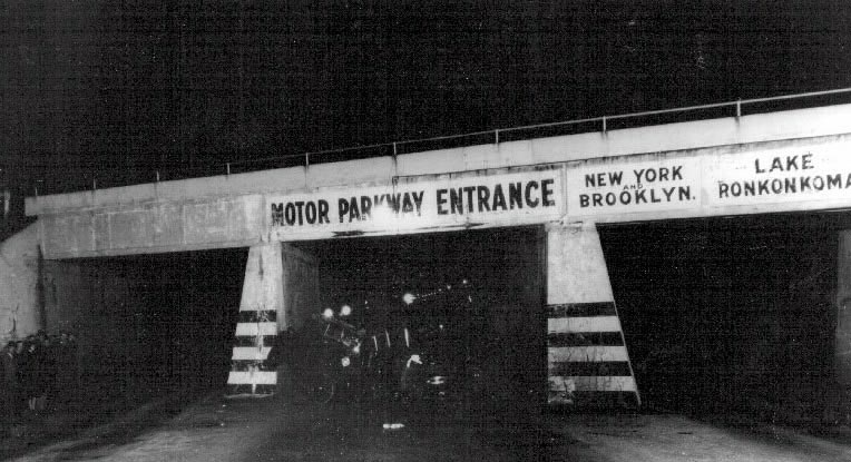
Looking north. Circa 1930s. Courtesy of Ron Ridolf.

Circa 1938.
Broad Hollow Road Motor Parkway Bridge, Melville
Westbury Avenue Motor Parkway Bridge, Carle Place/Mineola
Femenias' Findings (Submitted by Frank Femenias)
Clinton Road Bridge
Westbury Avenue Bridge


Comments
Identify the Motor Parkway bridge. Provide a rationale.
-Clinton Rd bridge; notable for it’s additional center supports which are unique even to other LIMP bridges with additional supports.
What is the likely orientation of the photographer? Provide a rationale.
-Utility poles on the East side; looking Northward up Clinton.
I am going with Westbury Ave.
Why you ask?
The LIMP built three bridges in the original build that were larger and wider than standard highway bridges. These bridges had trestle type support beams in the center supporting the structure. One of these bridges was over Broadhollow Rd in Melville, sporting an opening for the trolley line that ran from Amityville to Huntington. But you say this picture is from 1909, and that bridge was built in 1910. At least that is what I know.
This leaves Westbury Ave and Clinton Rd in Garden City. How did I narrow this down? (1) I do not believe the telephone pole and wires we see in this picture were along Clinton Rd. I have no evidence to support this either way at Westbury Ave. (2) As I closely examine the picture, I am not convinced it is Clinton Rd. The support wall on the right side of the picture looks more narrow. (3) I just feel it is way more likely a picture of the Westbury Rd bridge would have stayed hidden and unpublished than the one in Garden City.
Final Answer. The 1909 Built out of the Westbury Ave bridge of the LIMP.
Once again thanks to everyone who supplies this pictures. This is fun.
First try is: NY Route 110 looking North as there is a second opening which might be
for the Trolley Line.
Second try is Clinton Road, Garden City, again with a second lane opening.
No much else to go on for identification. CHEERS, Ron
Broad Hollow Road ~ Route 110 looking North, with space on East side for Cross Island Railroad tracks.
Thanks Gordon for the interesting challenge. Likely facing S (sharp angle of sunlight under the bridge). If facing E, the wall would’ve lit up more. At about 2PM in the afternoon, they’re wearing long sleeves (likely not summertime), not in Levittown (missing the flat plains), bridge slightly off perpendicular to the roadway below (about 95 deg), power lines present, likely a highway/farmway bridge.
Definitely not Mayan Ruins (though it could’ve been), not Nibbe’s (missing Deadman’s Curve #2 just after, the infamous 135 jog). I’ll go with Powell Ave highway bridge on this one, with Central (Bethpage) Park to the left. The power lines are in the approx correct location as today. What fun! Hope I’m right, can’t wait for the answer. Let’s go Howard, speed it up!
Clinton Avenue Bridge looking north?
*ID LIMP bridge/rationale: My personal best guess is the soon to be Half Hollow Pkwy Bridge in Wheately Heights. This overpass was completed “around 1910”.
*Likely orientation of photographer/rationale: East or West. East sits right with me after viewing the aerials on the site here. Some of you excel at figuring sunlight and shadows with these images, but not I.
Happy Memorial Day to All!
Strike 1 for me, trickier than I thought. A 1909 Parkway type bridge running east –west (photo looking south), with power lines running perpendicular to LIMP, along the west side of the roadway below.
Two possibilities with such an arrangement; Willis Ave and Round Swamp Rd.
Since Round Swamp Rd had a hill below it’s curved bridge, I’ll go with Willis Ave parkway bridge. Good luck on this one folks
Can’t remember and can’t make out something vertical in the distance which I believe is the vital clue. However, this is EXACTLY the kind of works progress picture Willie took or had taken in profusion and printed in the missing booklet I note at <http://sbiii.com/limpkwy0.html#limpbklt>. Has anyone actually visited the Hempstead Public Library to search for it in the archives? That would be one of the LIMP finds of the century! Sam, III
This bridge appears to have a pillar on the right, and telephone pole(s) on the right behind the construction. My guess is the Broad Hollow Road bridge (110) looking north in Melville.
I’m not 100% certain but it sure looks like a two pillar parkway bridge so I’ll guess the Clinton Road bridge. Based on the shadow from the sun, I think we’re looking south.
I’ll go with the Westbury Avenue as there appears to be a Lane for a
Trolley Line. Also the telephone poles seem to be placed correctly. View looking
West.
Looks like the Clinton Road bridge in Garden City based on the height and the support structure design, leaving room for the existing sidewalks.
Orientation - Facing south on Clinton Road, MP running east to the left.
Upon investigating this week’s photo it seams that the bridge has an extended section of concrete with a single pillar which is on the right. If my belief is correct, there were 2 bridges on the LIMP that had this design. The 2 bridges were the Broad Hollow Rd bridge in Melville and Westbury Ave bridge in Carle Place/Mineola. It could not be the Broad Hollow bridge since it was built in 1910. The Westbury Ave bridge was built in 1909 the same as the bridge in the photo.
I compared the photo and its design with the other bridges built on the LIMP in 1909 and found that the only other bridge it could be would be the Willis Ave bridge. In the only known picture of the Willis Ave bridge it appears that the span on the bridge was wide and possibly a single pillar bridge.
The only problem with the Westbury Ave choice is that I do not see any signs of the N.Y. and North Shore trolley line.
The terrain of the photo matches that of Westbury Ave more than Willis Ave. The shadow of the sun on the bridge appears that the ROW of the LIMP is in a north south direction.
The photographer would taking the photo facing to the east since the smaller passage way under the bridge was on the right side for the trolley.
So my educated choice would be the Westbury Ave Bridge.
Seth G:
I read these each week, but usually don’t attempt to answer.
Considering the early year (assuming they started construction in Queens), the parkway elevated, the sun appears to brighten the area in the distance & there are a lot of trees… It could be at 73rd Ave looking East (if it’s in the morning) looking towards what is now Cunningham Park.
Pillar on the left is fully formed. The pillar on the right doesn’t appear wide enough towards the base, yet. This makes sense since the bridge construction is still in process. Perhaps this image was cropped for mystery purposes? Find out on Tuesday. Great image, Gordon.
If the photo is of the Clinton Rd bridge, the direction of the photo I believe would have to be to the south. This is due to the shadows and the brightness of the sun. The photographer is facing into the sun. You can see the shadow cast onto the left side of the bridge embankment. I also believe that the bridge is only a one pillar bridge. You can only see one pillar. The pillar on the left I believe is the bridge’s embankment and not a pillar. You can tell were the top concrete section begins on top the embankment.
I haven’t the foggiest idea BUT those aren’t “pillars” (columns), they are “piers” (full width) AND they appear symmetrical, which knocks out Clinton. Can’t tell but IF the whole bridge is symmetrical, as it appears to me, that would nix the trolley line bridges, Westbury and Broad Hollow. Also, BHR is out because it only had ONE pier, The piers are tapered, so not Queens. Funsies. Sam, III
I am not convinced this is Garden City. Clinton Road always seemed so wide. In this picture is seems to narrow. The outermost underpass lanes seem like they are dirt and weeds. The left pillar is straight in the inside wall, and expands outward towards the left. Just like the Clinton Rd bridge. But the right side pillar seems to be straight down as a right angle in the middle, yet it does not appear to become wider at the bottom, the way the Garden City bridge does.
Things I would like to know. Does a good picture of Westbury Ave exist. Were Garden City and Westbury Ave basically built off the same blue prints? Or are they different? How wide was Clinton Rd in 1909? I would love to see someone identify this bridge at 100%.
Cannot be north, impossible. Could be Clinton bridge looking south but that would put the power lines on the wrong side. Clinton had power on the east side. I need an advil
Headache, indeed! Frank, if it’s hammering you, try an anvil. Interesting how we all see rather different things in this picture. I see equal taper on both piers and full symmetry, thus disagreeing with most everybody (as usual). Wonder if this will be a flat-forehead “Well, DUH!” (IF it ever gets solved). I still think whatever is in the distance, over the worker’s head, is the clincher - sure looks like a windmill tonight. Sam, III
Everyone needs to consider the source of the photo. This came from the Ernst family collection who were the original Lodgekeeper, and later, the decades long inhabitants/descendants of the Garden City lodge. While it’s plausible that they could have aquired historic photos of other LIMP bridges, odds are more in favor that the photo would be of the nearby Clinton bridge.
I told you, Frank F. This mystery image is taking on the status of yours from 2013 ( 4/9/2013 Mystery Foto #9 Possibly Solved: Powell Ave Bridge and Nibbe Farmway Bridge in Bethpage? ) We may break a record here for the amount of comments.
If the photographer stepped back 25 ft or so and then snapped the image, we’d probably be able to figure this out 100%. Guess we have to keep in mind this was 1909. So Clinton Rd likely wouldn’t have been as streamlined as it looks in 1926.
We’ll have to keep searching for a clearer image of the Westbury Ave Pkwy Bridge, Joe O. But like Frank M. mentioned, there should be trolley tracks where the road is. Westbury Ave extended west to Roslyn Rd post year 1926, following the former ROW of the trolley line.
I do believe that is a pier to the left. It becomes wider towards the bottom. The pier or pillar to the right looks the same at the top and bottom. I know nothing about bridge building but this one is not a finished product, obviously. I hope you have some more images, Gordon. Thanks, BDM
Joe O.- Those were some of my first thoughts as well, but remember, since it’s still under construction, they have not cleared out the outer passageways of debris so it appears to be not as wide.
Frank- since the flying field was on the East side of Clinton it makes more sense that utility poles were on that side. When I saw Howard’s above ‘30’s photo looking North, that was my semi-confirmation. However, We need a better photo confirmation of that to be completely fair.
Joe - To add to the Clinton Rd Bridge, the 1930s photo above shows Clinton Rd still narrow, but widened just for the underpass below the bridge. This north-facing photo also appears to show some light seeping in onto the left pier, like the mystery foto. The railings also seem to match the mystery. This bridge sat in a NW to SE position because of it curved properties. I’ll be visiting soon to conduct a light/shadow test
A good tool in helping with this mystery is with the my Nassau property aerials. In the mystery photo you can observe a big stand of tall trees on the left side of the bridge past the bridge. In the 1926 aerial of the Clinton Rd area you do not see any stands of trees. You can look to the northwest and to the southeast without seeing any trees. This would correspond to the mystery photo depending if the photo is facing to the north or south.
I know that the aerial is taken 17 years later, but why would all the trees be removed? The land looks very barren and is not farm land. The only trees you can observe are planted along Clinton Rd in the 1926 aerial. I do not believe that the mystery photo is Clinton Rd based on this observation. Where did the trees go?
Another observation I made is that the terrain in the mystery photo does not match the later photos of Clinton Rd looking north. The slope of the ground seams to go up after the bridge. The slope of the roadway in the mystery photo seams to be level. A big mystery?
First, there were at least four Parkway bridges in Nassau County that had more than a single span. These were at Willis Ave., Roslyn Rd., Westbury Ave and Clinton Rd. I believe there were more. The average length of a single span Parkway bridge was between 25 and 30 feet . The bridge over Marcus Ave. was 72 feet long and the one over Lakeville Rd. was 66 feet long, both good candidates for more than a single span.
O.K. - ignore my comments, guys - I’ve got thick skin. BUT - does Gordon know the answer or are we all shooting in the dark? IF it’s Clinton and asymmetrical, then it’s looking SOUTH! Check the piers in the Clinton pix. Further, the Curtiss plant was (and still is) on the SOUTH side of Stewart, thus SOUTH of the LIMP bridge at Clinton; however pole lines go in TWO directions. Some of the reasoning expressed in prior comments simply doesn’t hold water. Frank M., the vertical thingie at the left is a pier; embankments are NOT free-standing, with caps - they have wing walls at each end and go all the way up to the roadway level. Is definitely a puzzlement! Sam, III
If this was looking South at the Clinton bridge, wouldn’t we see construction of the Curtiss plant down the road on the left?
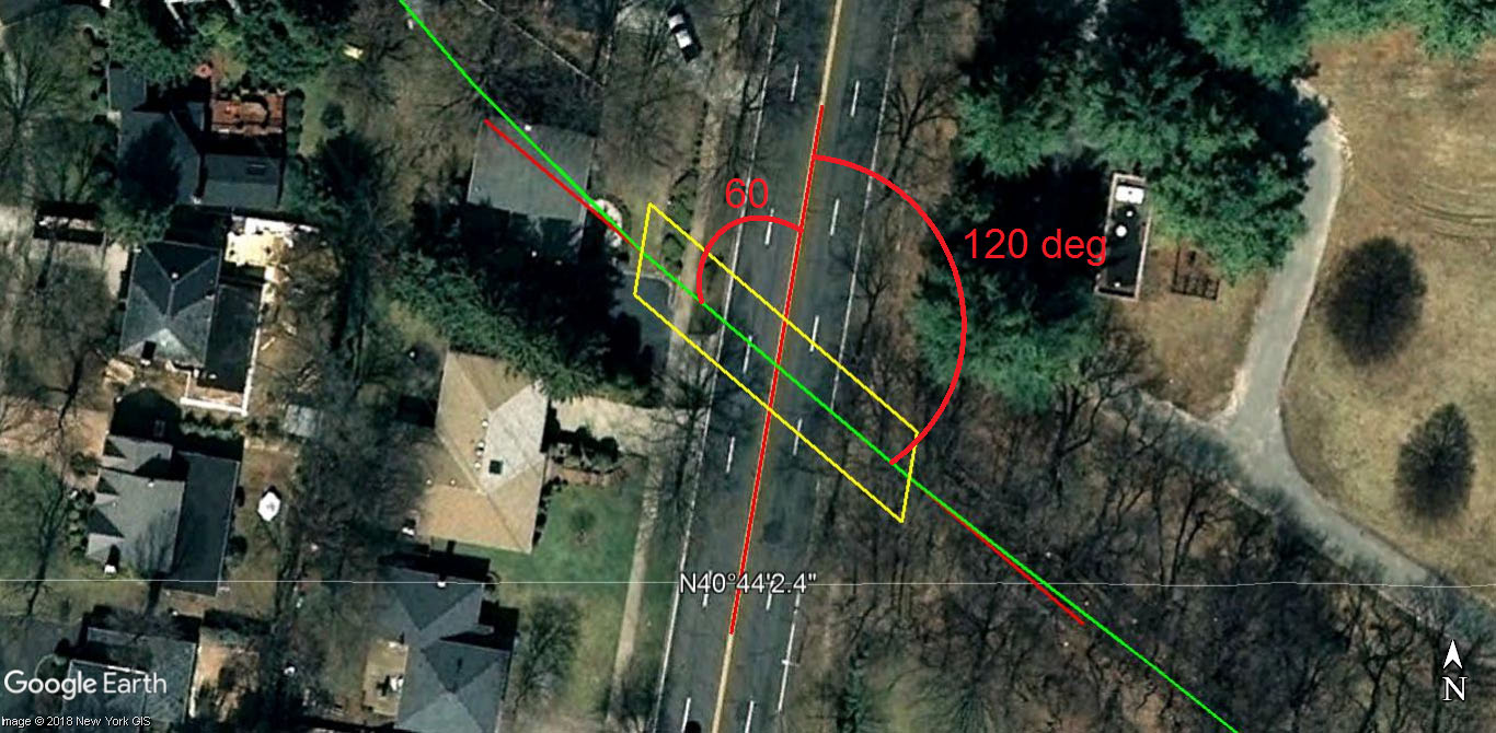
Does look like two piers underneath but Clinton doesn’t mesh. Photos can be deceiving but the bridge angle compared to the road is way off to be Clinton, in fact appears angled in the opposite direction regardless which way you’re looking (appears about 5 degrees off perpendicular). Bridge angle also doesn’t match other aerials showing appropriate angle. (sending Howard photo).
Sam - The worker on the ground with shovel appears a tree behind, over his head, then more trees further in the distance. Any object in the distance would’ve helped here.
Frank M - If I recall correctly, there was a development built about the same time across the street from, and associated with Curtiss flying field on the other side of Clinton. That may account for the trees disappearing.
I think the piers on the ground may protrude past the bridge railing above. If so, this will allow some sun to hit the pier even if facing north. Truly baffling.
Greg O. - no, the old plant (I worked in it ca. 1957) was some 300’ east of Clinton, behind the later (today’s) office building, and the same distance south of Stewart; the trees in the distance are about where Stewart is and would have hidden the plant. Could my “windmill” be a construction crane? Nah - much to far west and north. Frank F. - I don’t recall the exact house but I looked at a house in there ca. 1968 that had been built for a top executive, as were the neighboring houses. They were between the LIRR tracks and Stewart, and between Clinton and Washington. You know, now that I think back, it may have been built for the Commanding Officer of one of the many bases in that area, a Navy Admiral mayhap. This is a real “strain the brain"er! Hurrah for Gordon and Howard! Sam, III
Comment #32…You’ve been quiet, Gordon. I hope we didn’t scare you away.
Sam, the trees appear to be much closer than where Stewart Ave would be? The tree line goes up to the left side of the bridge in the photo (I believe it’s much closer than you may think?). I think your “windmill” is either a large tree just off the side of the road or a large blemish in the negative like the ones on the top of the photo? I guess that’s my 2 cents, who knows. Any more idea’s
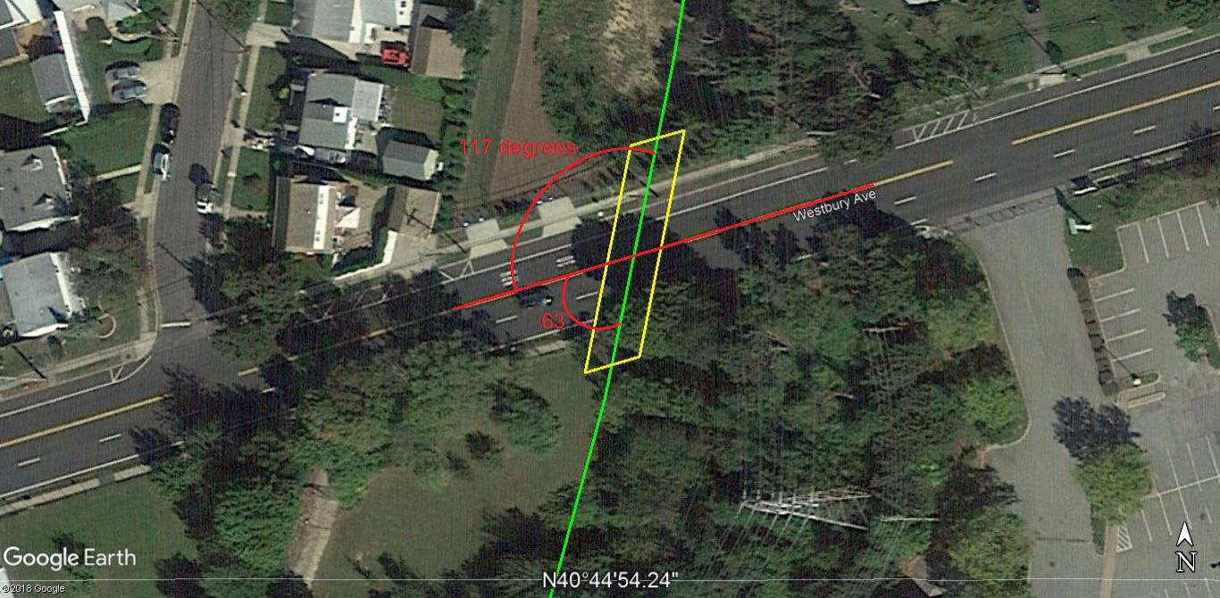
Admiring the diversity of thought here! There is also the possibility the photo is looking East but ONLY early in the morning before noon. If looking East, the shadow directly behind the worker on the ground is indicating about 10am. The Westbury Ave bridge (traveling north-south), also with two piers, could be the solution, and was located only 1 mile from the Clinton Rd bridge via Motor Parkway. Because of the proximity of this bridge and the Garden City lodge, it’s also quite possible Gordon’s grandparents possessed this photo of the Westbury Ave bridge, sister to the Clinton Rd bridge.
One more; the opposite angle and slighter curve of the Westbury bridge matches closer to the mystery, than that of the Clinton Rd bridge. Sending Howard a photo after another advil.