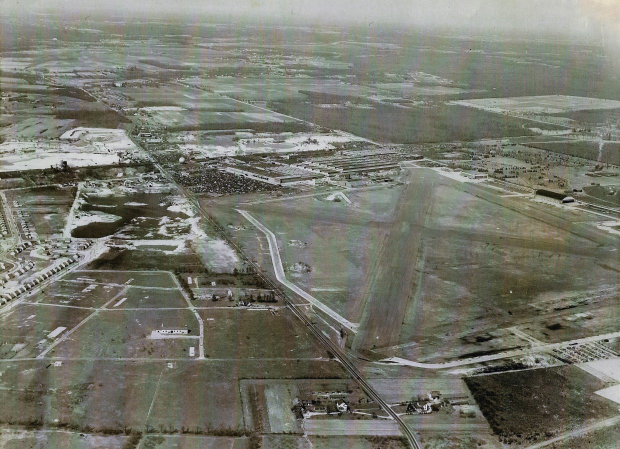
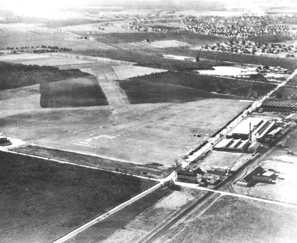
Mystery Foto #19 Solved: The Republic Airport in East Farmingdale in 1951
My Favorite Co-Author Al Velocci challenged you to identify this weekend's Mystery Foto.
Answers to the Mystery Foto questions:
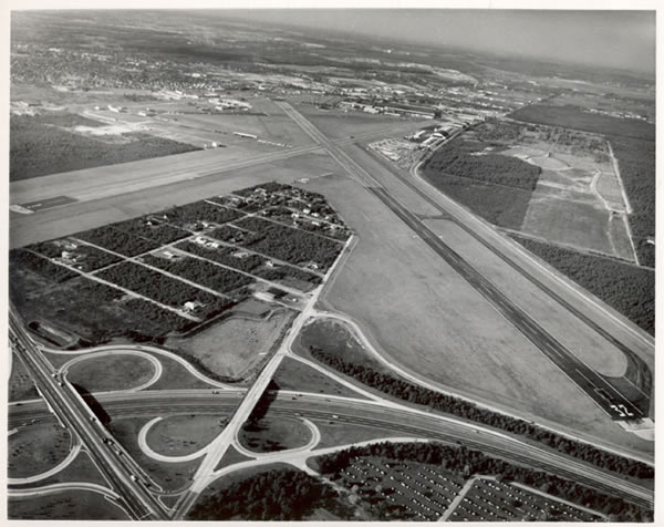
- Identify the location, airport and orientation of the photographer
Republic Airport in East Farmingdale looking northeast.
- Although not visible, where is the Motor Parkway in the aerial?
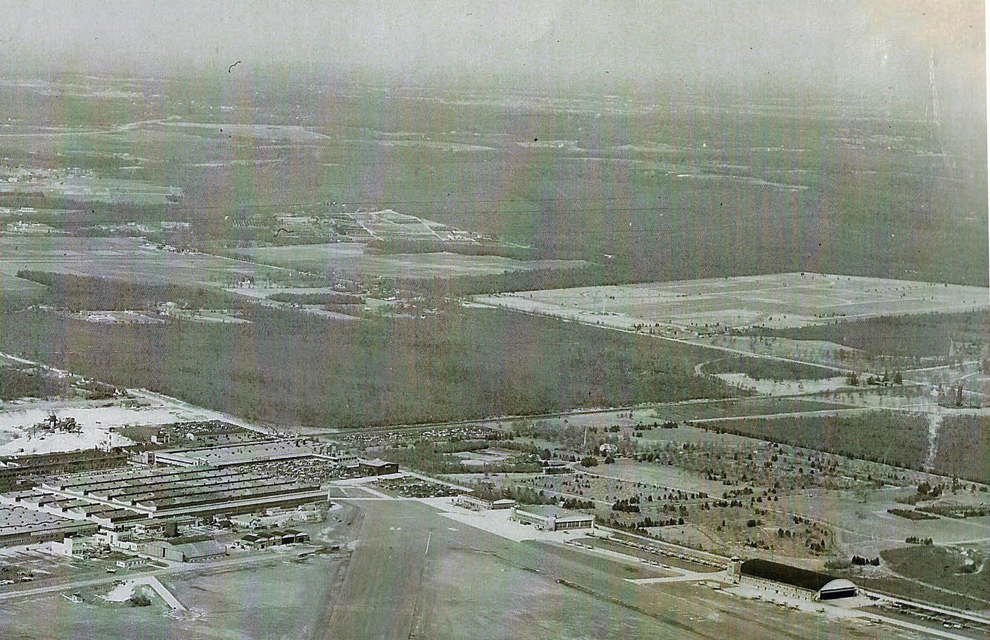
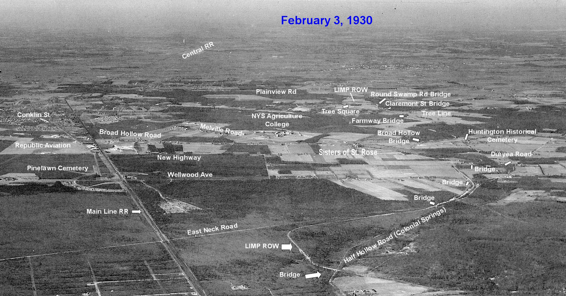
Across the top of the aerial as seen in Brian McCarthy's below jpegs.
- Link this airport with many of the aerials on VanderbiltCupRaces.com .
Republic Airport was originated developed by Sherman Fairchild. Among Fairchild's many companies was Fairchild Aerial Surveys.
- What other historic property can be seen in the Mystery Foto?
The Long Island National Cemetery "Pinelawn"can be seen in the top right corner.
- What was the date of the Mystery Foto? Provide a rationale.
This aerial was taken by a New York Mirror photographer on February 24, 1951 by "Hopkins' pilot "Speed" Manzlik".
Comments (7)
Congrats to Greg O., Wayne Woodbury, Ernie M., Ron Ridolph, Roy Warner, Brian McCarthy and Sam Berliner III for identifying Republic Airport. 100% of all Comments.
Kudos to Greg O. for linking the Mystery Foto to Fairchild Aerials.
Stay Safe, Stay Healthy, Save Lives,
Howard Kroplick
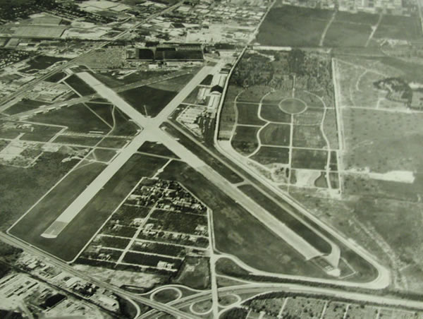
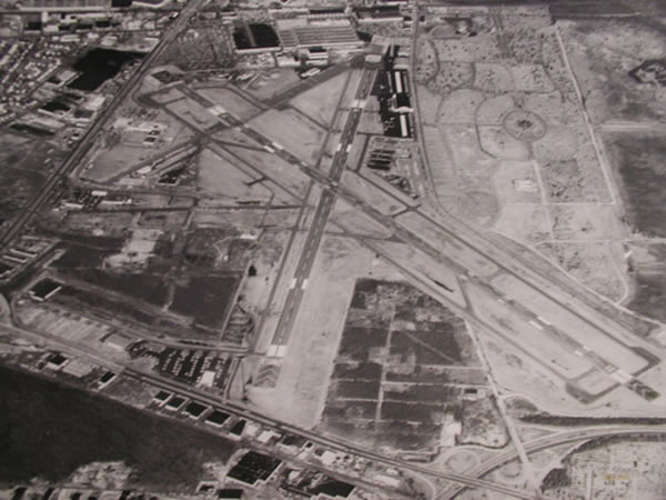
Close-Ups
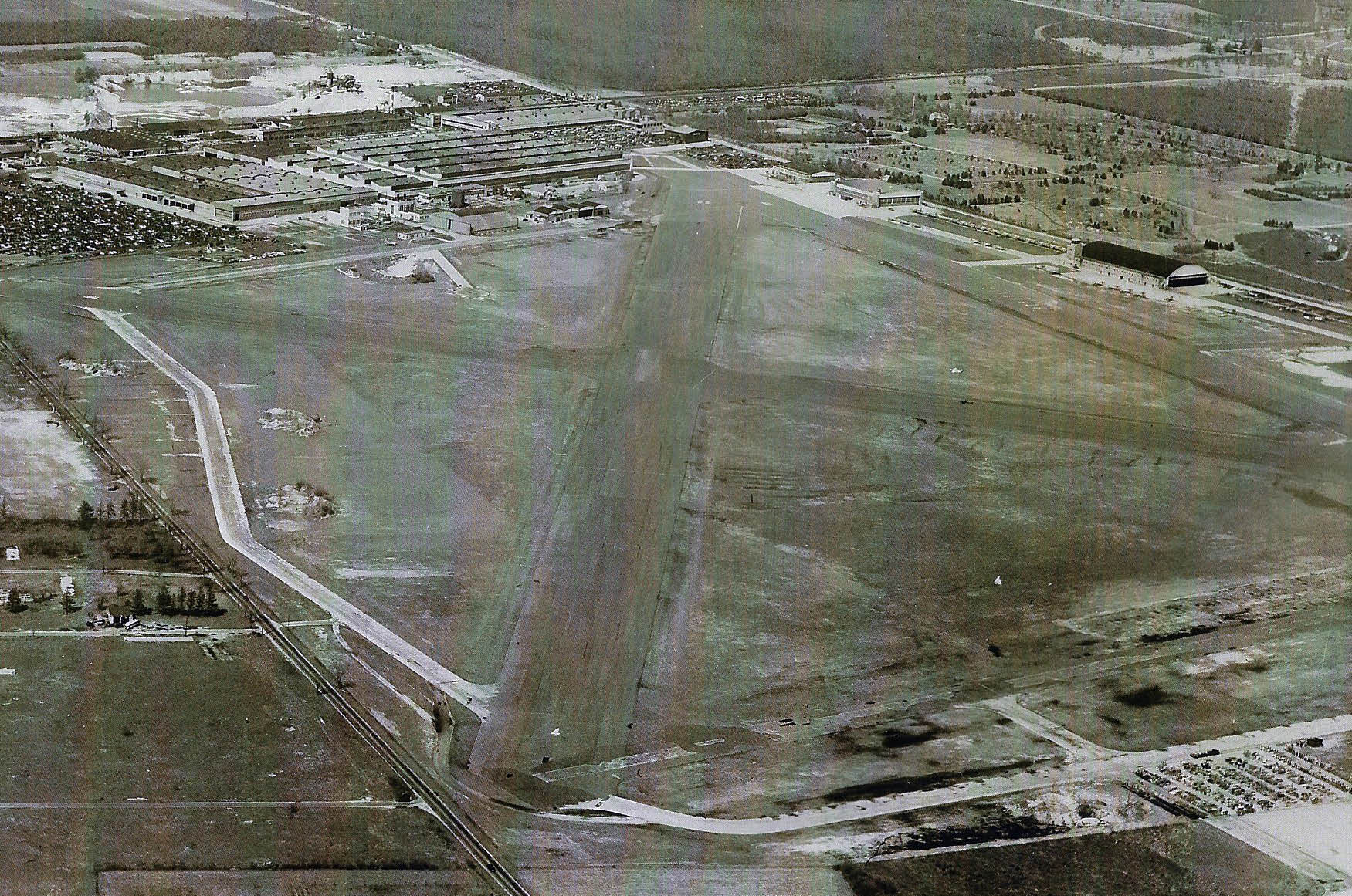


1952 Map of Republic Airport in relation to the Motor Parkway and Pinelawn
A 1930 Fairchild Aerial
Republic Airport
1928
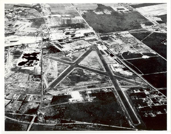
February 1950
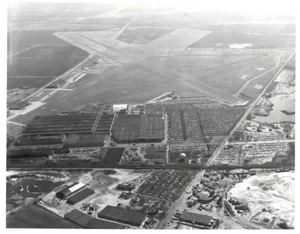
1954
Undated
1971
1981
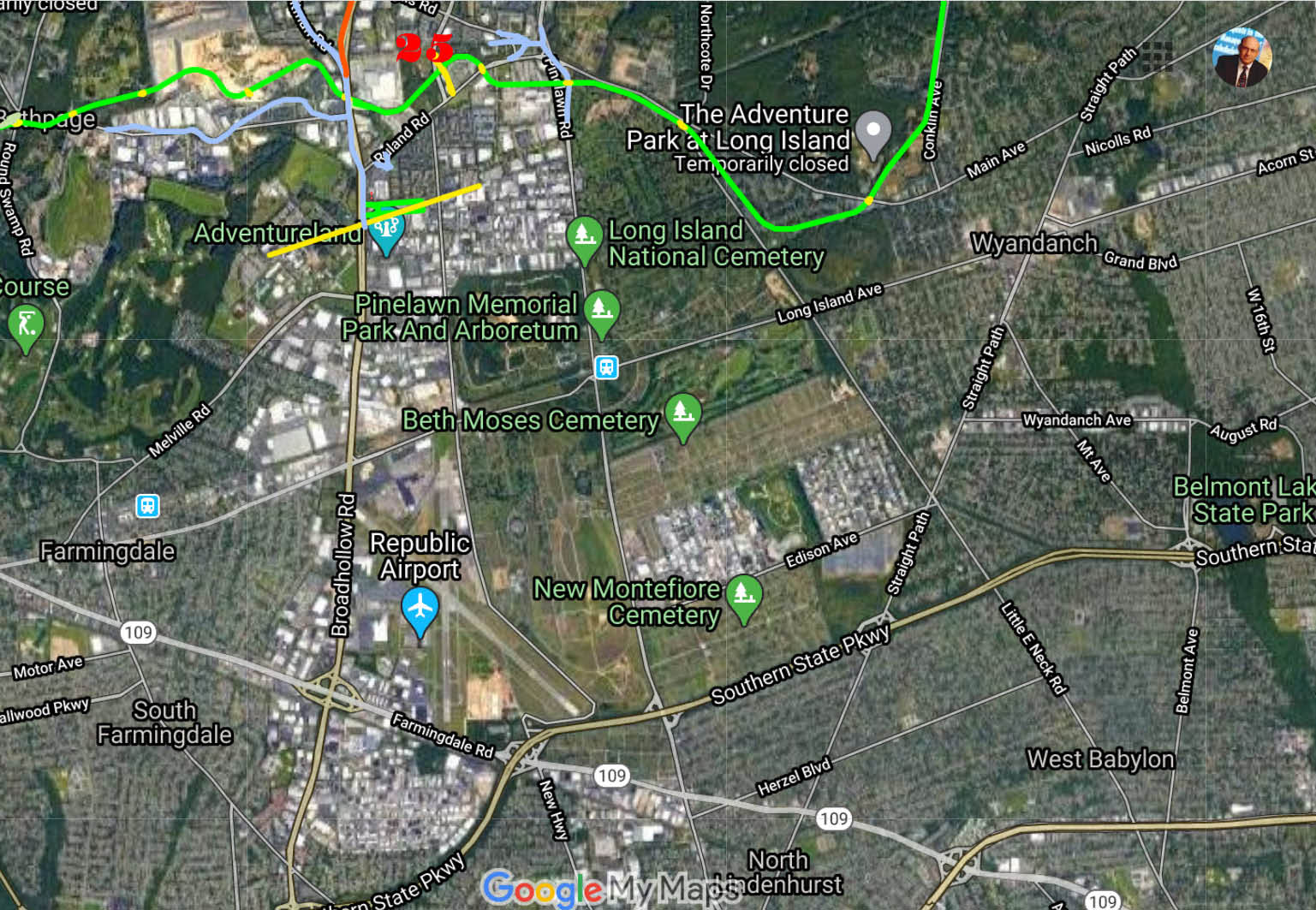
Google Earth


Comments
-Identify the location, airport and orientation of the photographer
Looking North up Route 110 at What is now Republic Airport in Farmingdale.
-Although not visible, where is the Motor Parkway in the aerial?
Way up on the top far off in the background starting from about where the sand pits are, to around Colonial Springs Rd.
-Link this airport with many of the aerials on VanderbiltCupRaces.com.
The flying field was developed in 1928 and was originally owned and operated by Fairchild Engine & Airplane Manufacturing Company who was responsible for photographing many of the aerials.
-What other historic property can be seen in the Mystery Foto?
Very far off, but unseen is the Huntington Historical cemetery, St. Rose home for girls, the future site of the National Cemetery, and maybe a blob that might be the Huntington Toll lodge?
-What was the date of the Mystery Foto? Provide a rationale.
Judging by buildings, runways and similar look to other aerials, I’ll say 1954.
This is the Republic Fairchild airport and aircraft factory in Farmingdale. The photographer is looking north with rt 110 (Broadhollow Rd) running from top to bottom on a left to right diagonal. Just north of the plant is Conklin Street and the LIRR main line. https://sites.google.com/site/lirepublicairporths/new2 has a picture from the 1950s that seems to match. The LILCO gas globe is also a clincher. Judging from the large number of cars in the parking lot and their approximate style, this would be the 1950s. Pinelawn National Cemetery would be in the upper right of the photo. That may be the Pinelawn RR station in the extreme upper right corner. The Motor Parkway would be along the north and east boundaries of the cemetery.
Identify the location, airport and orientation of the photographer
> The photographer is at a few thousand feet above Farmingdale Republic Airport looking generally north
Although not visible, where is the Motor Parkway in the aerial?
> I would not be too sure there isn’t a few pixels of the LIMP as it runs left and right along the top of this photo.
Link this airport with many of the aerials on VanderbiltCupRaces.com .
> Google was not my friend on this.
What other historic property can be seen in the Mystery Foto?
> Pinelawn Cemetary is on the top right.
Broadhollow Road / Rt 110 runs left top to center bottom.
The buildings of Republic Aviation are at the north end of the field.
What was the date of the Mystery Foto? Provide a rationale.
> Post 1939 when Republic took over from Grumman and built the three hangers and control tower.
With all the activity there I would put 1945 as the latest date.
Current Overhead:
https://www.google.com/maps/@40.6955423,-73.4216622,1893a,35y,355.05h,66.55t/data=!3m1!1e3
Location: Farmingdale, NY // Republic Airfield, starting out by Sherman Fairchild in
1927-28, Grumman using it in 1932-1937, Seversky coming in 1935 and became
Republic Airfield. Sold to Fairchild- Hiller and other FBO’s then to the MTA and now
under NYS DOT operation. Runways: 14/32 and was extended S/E and 10/19.
LIMP is at the top of the photo going west to east. Photo Date: 1930’s - 1940’s
1. I’m pretty sure it’s Republic Field, now a general aviaton airport. I took my son to flying lessons there starting when he was 11 years old. He is now a pilot for one of the majors. The view is looking NE. The runways were extended, realigned and redone through the years after the War.
2. To the East is New Highway, north/south, with the Pinelawn Cemetery a little east and to the north, which is visible in the photo.
3. Had to have been taken during WWII. The plant abuts to the north; cars can be seen in employees parking lot.
4. The LIMP was way to the north on Rte. 110.
5. A movie theatre, big box and other stores now exist where the plant and employee parking lot. I haven’t been back to Republic for 16 years, so I don’t know if the stores have changed.
*Location, Orientation, Airport: East Farmingdale, Suffolk County NY. Viewing north & east, Republic Airport; previously Fairchild Airfield.
*Location of the LIMP: Along the upper part of the image.
*Date: Around 1950. Appears younger than 1947, but older than 1954.
Wow! I can name an awful lot of LI airports within view of the LIMP but not a single one with equilateral runways! With that huge plant, you’d think it had to be Grumman or Republic. Verrrry interesting. Ya got me, Umberto, baby! Sam, III