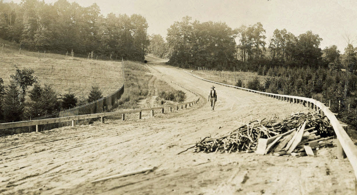
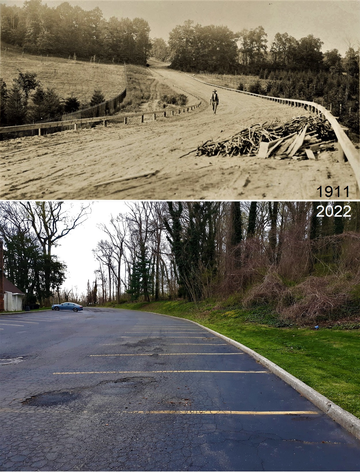
Mystery Friday Foto #17 Solved: The Motor Parkway under construction north of Marcus Avenue in Lake Success (Circa 1911)
The Vanderbilt Museum Archives challenged you to solve this weekend's Mystery Foto.
Answers to the Mystery Foto questions:
Identify:
- The location and orientation of the photographer. Provide a rationale.
Greg O.:
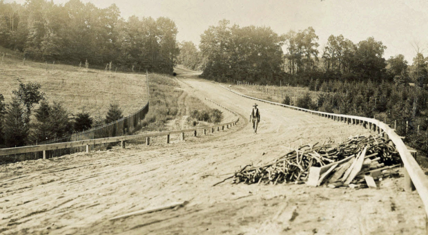
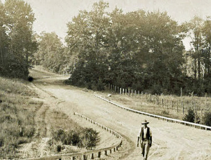
Looking north on the newly constructed section immediately on the west side of Lakeville Road on Willie K’s property. Photographer is standing on the north embankment of the Marcus Ave Bridge (second bridge after leaving Great Neck heading west) Lakeville Road Bridge and Great Neck Lodge just beyond the right hand curve in the background.
Trees in the aerials match and the photographer is located on the ‘X’. Willie K’s fence can be seen on the left.
- The approximate date of the Mystery Foto. Provide a rationale.
Construction of this section of the Motor Parkway (west of Lakeville Road) began in 1911.
Comments (8)
Congrats to John Cunningham, Greg O., Steve Lucas, Brian McCarthy, Joe Oesterle and Al Velocci for correctly identifying the Lake Success location.
Kudos to Frank Femenias for taking the "Now " photo.
Enjoy,
Howard Kroplick
Hint
Hint: William K. Vanderbilt, Jr. himself provided the caption to the Mystery Foto.
Close-Ups
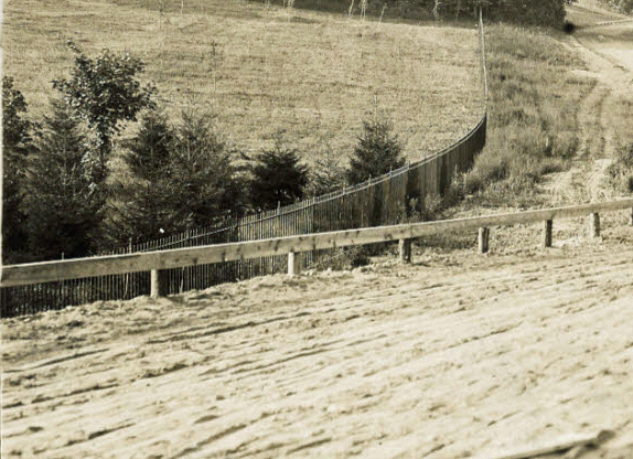
Note: The Deepdale Estate gate and the north embankment of the Marcus Avenue Bridge.
In the background the Motor Parkway curves to the east to Lakevill Road.
May 1911 Survey
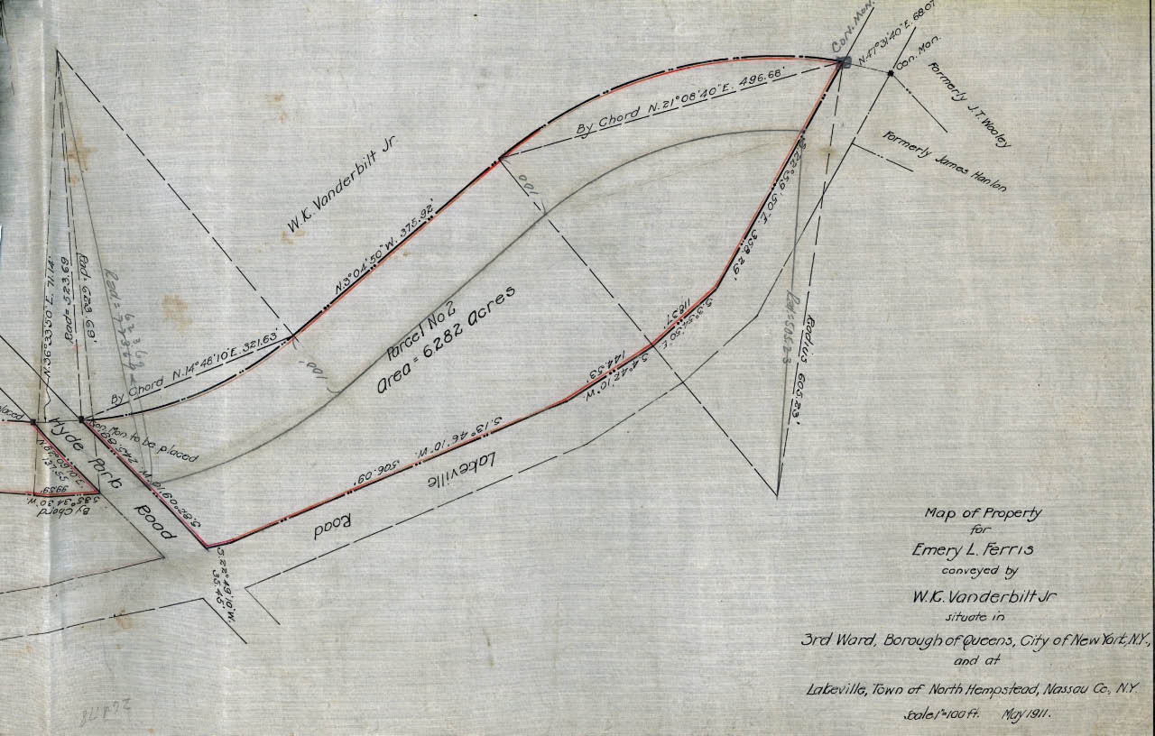
A survey of the Mystery Foto with the land conveyed by W. K. Vanderbilt Jr.. New Hyde Park Road would later be renamed Marcus Avenue.
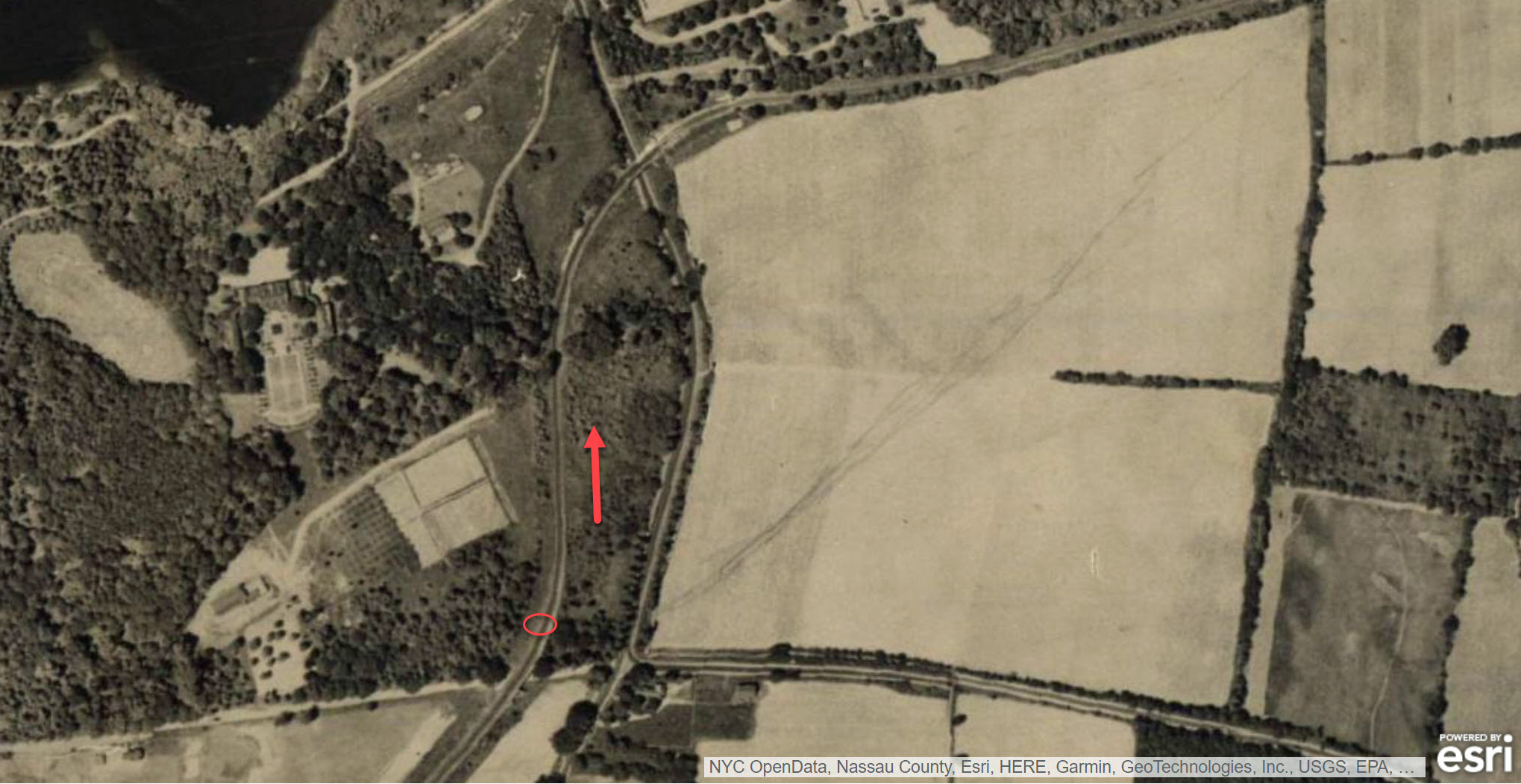
1926 Aerial
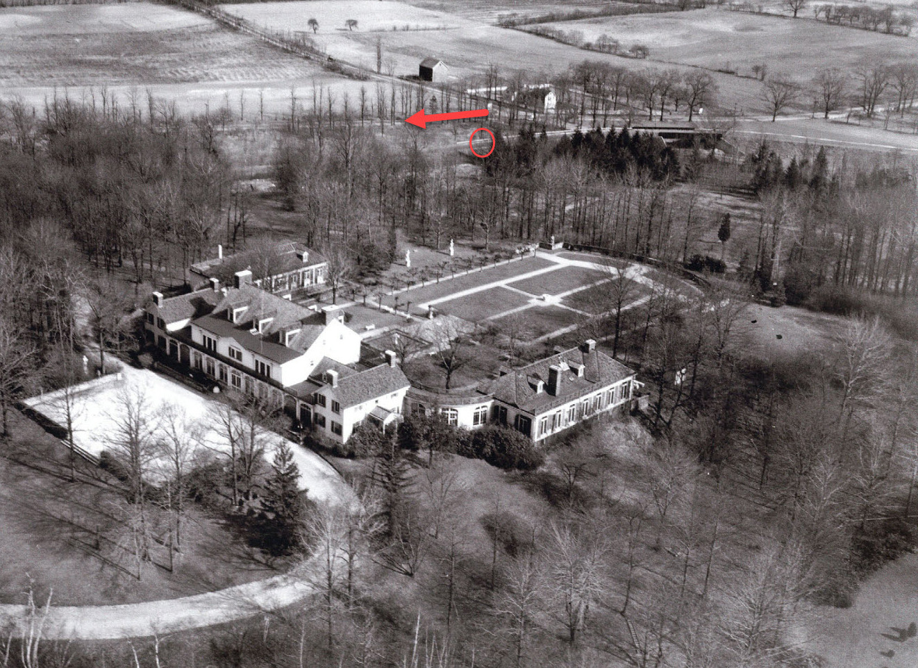
The location of the photographer in relation to the bridge of the Deepdale Mansion.
1927 Aerial
Now & Then: Courtesy of Frank Femenias
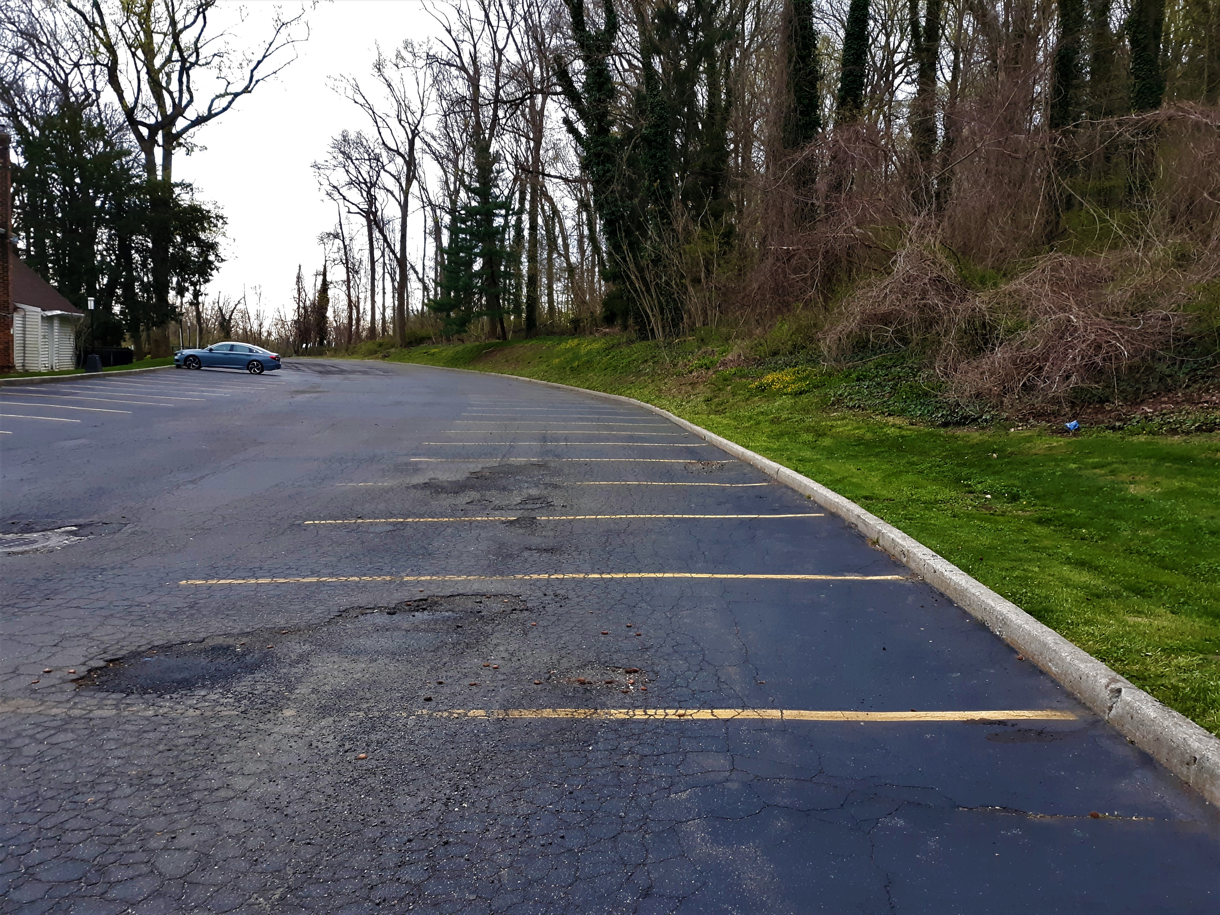
Brian McCarthy: "I went today to take the "now" photo, 111 years later. Boy, how the neighborhood has changed."


Comments
Deepdale looking east. 1908
As far as i can tell, the property that the parkway passes through by the western terminus would be deepdale. i picked 1908 because the caption talks about building progress.
Absolutely love this photo!
Looking North on the newly constructed section immediately on the west side of Lakeville Rd on Willie K’s property around 1911. Photographer is standing on the north embankment of the Marcus Ave bridge (second bridge after leaving Great Neck heading west) Lakeville Rd bridge and Great Neck lodge just beyond the right hand curve in the background.
Trees in the aerials match and the photographer is located on the ‘X’. Willie K’s fence can be seen on the left.
1911 survey map of the area sold by Willie K.
Based on Willie K.‘s clues, I think we’re looking north or maybe slightly northeast from the northern embankment of the Marcus Avenue bridge in Lake Success. This bridge was the second bridge going west from the Great Neck Lodge with the first bridge west of Great Neck being Lakeville Road. The date would probably be around 1910-1911 since the extension west to Rocky Hill Road opened in 1912. I think the area just behind the person in the photo (going left to right) is currently occupied by the Northern State Parkway.
Photographer is positioned on the LIMP bridge over Marcus Ave in Lake Success, snapped this photo viewing north towards the bridge rise over Lakeville Rd. Road construction west from The Great Neck Lodge began around 1914.
I believe I have this down to a 50/50. We (the photographer and I) are either on the Marcus Ave bridge’s northern end looking north, with the bend going right, and towards the Lakeville Rd bridge which cannot be seen. Or we are just south of the Lakeville Rd bridge, and it is the Marcus Avenue bridge we cannot see just past the far bend.
Either way, this is well before the northern state parkway arrives. Probably in the very early days of the parkway when it was first extended west of Great Neck.
Update to my answer, I say I am looking north. And Willie,s property is to the left. I believe in the Nassau County 1926 overhead picture this is made clear. And you can even see the tree
Iine near the far bend.
Other observation, those are wood posts lining the property. Not the cement ones made in the early 1920’s. Willie K’s estate fence is to the left.
This is an absolute treasure of a picture. I have been in this picture thousands of times. And many of those times I tried hard to imagine what it looked like here when the parkway was new. This picture is truly special.
The photographer is standing on the Parkway bridge over Marcus Ave. and looking north. Photo taken in 1910 ?
Guess there’s another Brian McCarthy LIMP fan here, because I didn’t take the now photo : )
Howard Kroplick: Thanks for the correction! Kudos to Frank Femenias!
The photo’s caption matches the view looking north towards the Lakeville Rd bridge, especially the numbered references to the bridges, and the iron fence on the left to section off the Deepdale Estate. However, the LIMP RoW ascent today is looking south, and part of the 3 mile iron fence was used along the Lakeville Rd perimeter of the estate. I would think the iron fence would better serve in isolating Lakeville Rd than the Motor Pkwy. Did Willie K mess up the caption?
Greg; The 6.282 acre plot from Marcus Ave. to Lakeville Rd. was not “purchased” from Vanderbilt. When the decision was made to extend the ROW westerly from Lakeville Rd., the Parkway Corporation was not in a financial position to purchase the necessary property. All the ROW west of Lakeville Rd. to Nassau Boulevard was owned personally by Vanderbilt and he “leased” that portion of the ROW to the Parkway.
This image could be the opposite way like your saying, Frank. This one would’ve been very difficult if there was no caption at all.
Brian, Complicating the whole scenario is that prior to the Parkway extension to the west was the photo taken of the Smith Farmway bridge with the caption. “1st bridge after Great Neck”.
Frank, Regarding you comment about the fence on the west side of the Parkway…I think that fence was put up to keep Parkway users from accessing Vanderbilt’s Deepdale estate and it most likely extended al the way to Lakeville Rd.
Al, Brian - The top photo below (1914) shows the iron gate parallel to Lakeville Rd at the Great Neck lodge entrance ramp (190 ft north of the Lakeville Rd bridge).
I can’t figure how the 1911 mystery gate connects to the 1914 gate if the mystery is looking north.
To add even more confusion, the LIMP RoW in question is ascending when looking south, while Lakeville Rd in the same area is descending.
Note the fire hydrant just north of the lodge’s entrance ramp. It still exists today (bottom photo below).
One more observation: The right side in 1911 looks more like Deepdale with planted trees vs the left’s open land, pre WWI. I’d bet the gate followed the Lakeville Rd bridge, then tucked under and headed north along Lakeville Rd. But I have no proof.