Update: Mystery Foto #16 Solved: A 1936 Braman-Johnson Survey Flyover Over the Hempstead Plains

Preservation Long Island reached into their archives to challenge you with this weekend's Mystery Fotos.
Answers to the Mystery Foto questions:
- Identify the location of the airplane and likely year this image was taken
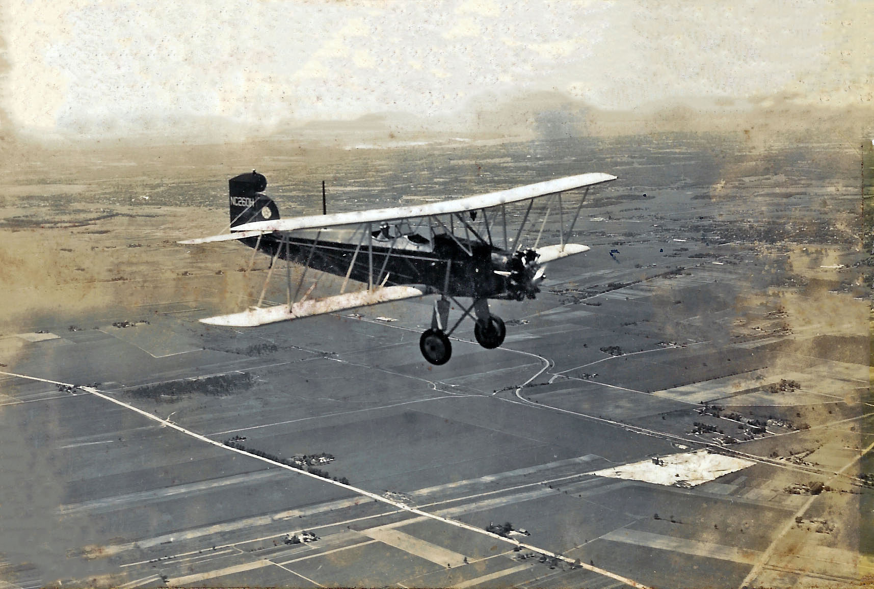
The survey airplane is flying over the Hempstead Plains (now Levittown) in June 1936.
- Identify the major roads and significant structures
The Long Island Motor Parkway can be seen under the wheels of the airplane. Hempstead Turnpike is the major road cutting across the lower left corner of the aerial. Bloomingdale Road, Wantagh Avenue and Hicksville Road can be seen to the right of the airplane. Look carefully and you will see three Motor Parkway bridges that crossed these three roads.
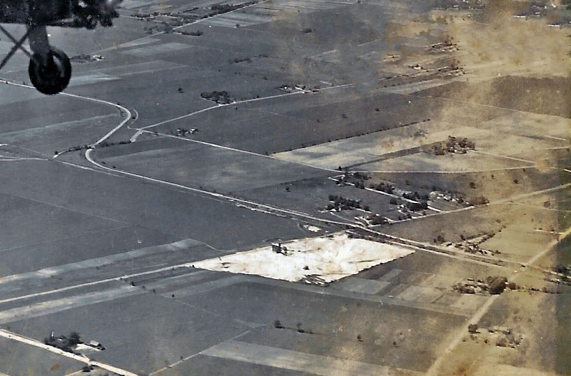
The Long Island Aviation Country can be seen under the right wing.
- Identify the survey company
Braman-Johnson Flying Service, Inc. which was based at Roosevelt Field.
- Identify the airplane
Curtiss Fledgling B-37 Reg. # NC260H
- Kudos question: The below aerials were taken by the same survey company. Identify the location and the likely year of these aerials.
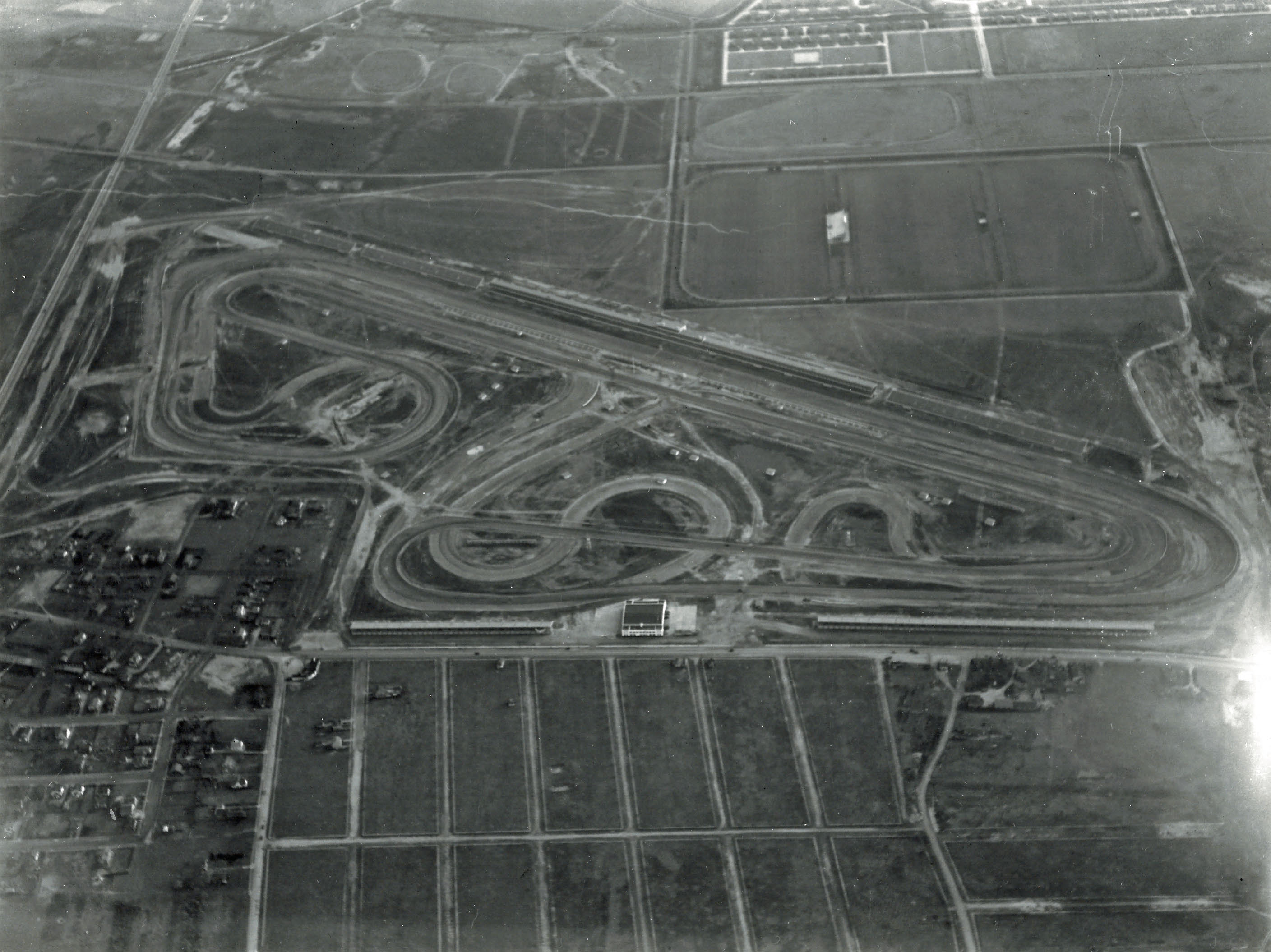
- A. Roosevelt Raceway, looking south, 1937-1940- after the Vanderbilt Cup race course was changes after 1936. Note: the Merrick Avenue Motor Parkway Bridge and Meadow Brook Lodge in the left corner of the aerial.
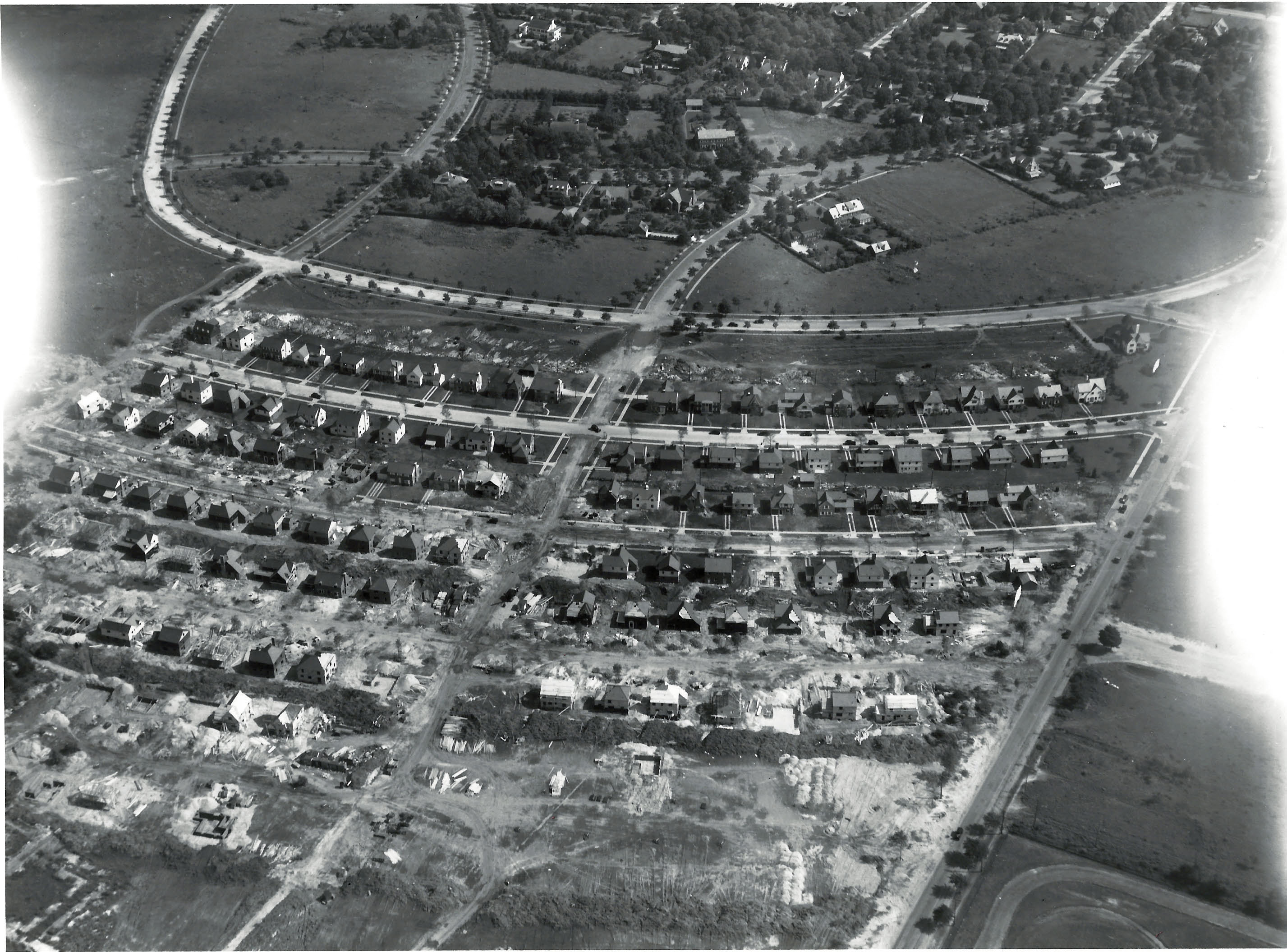
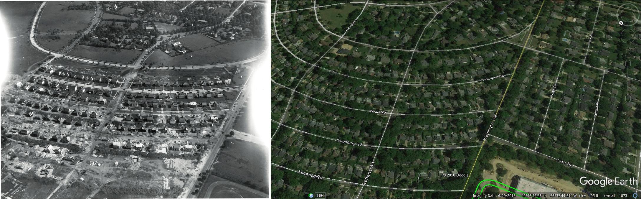
- B. Possibly the Mott section of Garden City- Still need to be confirmed
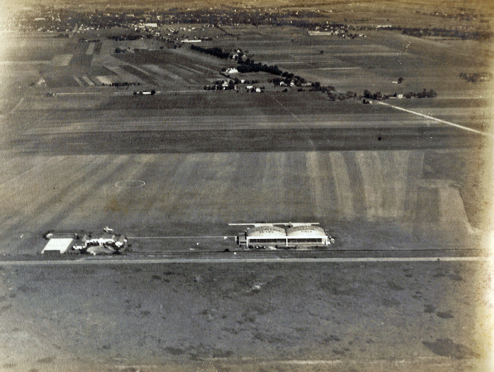
- C. Long Island Aviation Country Club, likely June 1936. The Motor Parkway can be seen below the hangars.
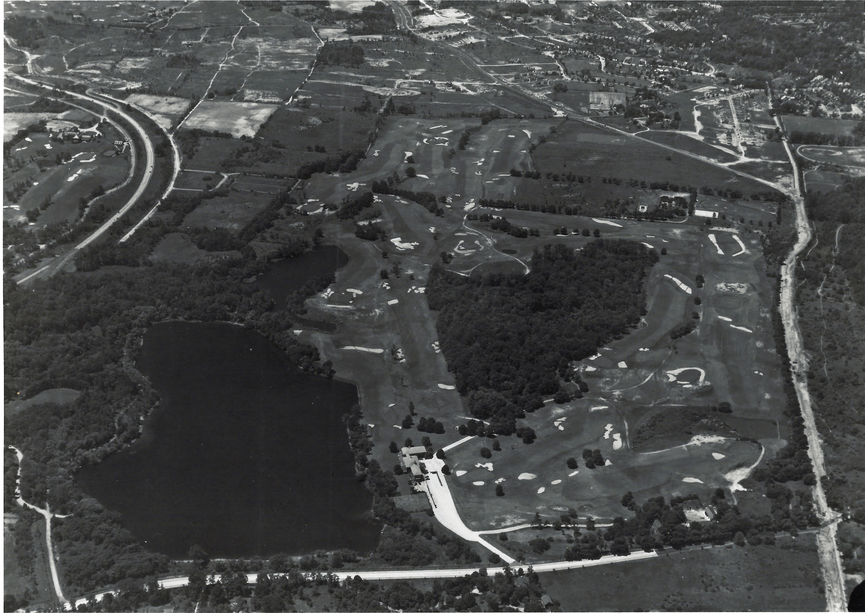
- D. Lake Success and Lake Surprise, looking west, Deepdale Golf Cub founded by Willie K., date unknown (circa 1937)
Comments (10)
Congrats to Gary Hammond, Richard Krause, Greg O., Art Kleiner, Tim Ivers, and Frank Femenias for identifying the Hempstead Plains.
Kudos to Gary Hammond, Greg O., Art Kleiner, Tim Ivers and Frank Femenias for identiying at least three of the Kudos Mystery Aerials.
Enjoy,
Howard Kroplick
Close-Ups
Survey Team: Braman-Johnson
Survey Team: Braman-Johnson
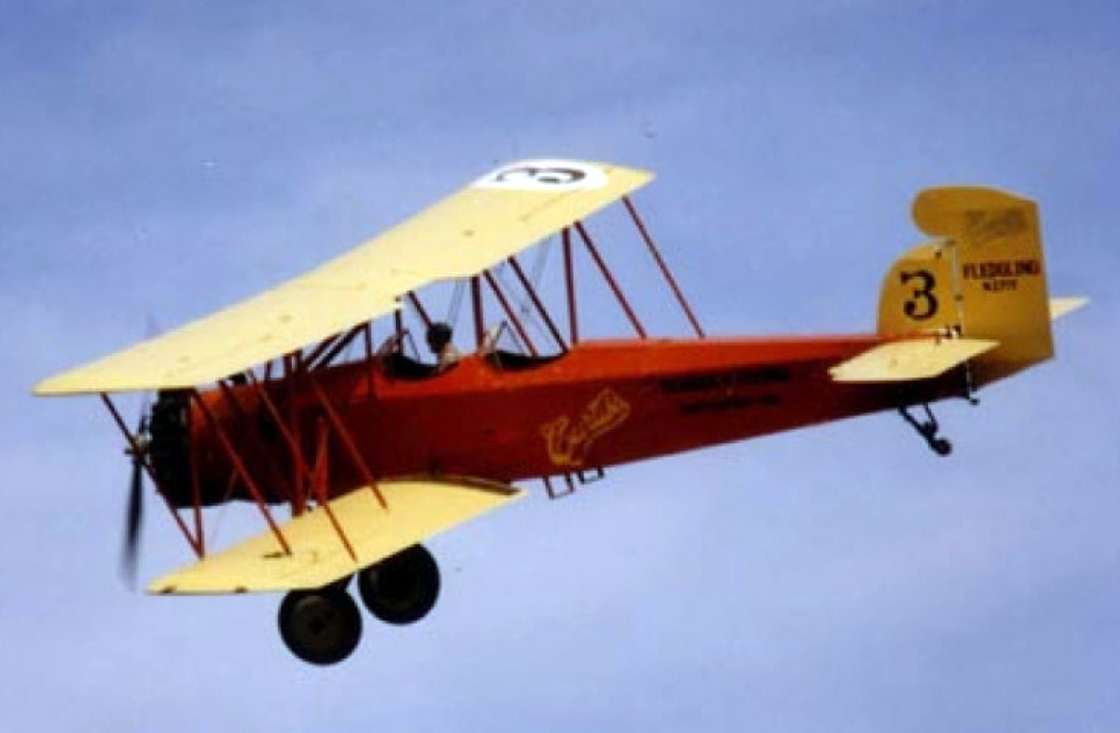
Curtiss Fledgling (1929)
Year: 1929
Engine: Wright J-6
Horsepower: 165
Wingspan: 39′ 1″
Top Speed: 102 mph (164 km/hr)
Gr. Weight: 2700 lbs (1225 kg)
Photos Taken by the Survey Company
A. Survey Team: Braman-Butters
Roosevelt Raceway 1937-1939
B Survey Team: Braman-Johnson
Mott section of Garden City under construction, looking southeast
Anyone have a date?
Submitted by Frank Femenias
C Survey Team: Bramen-Butters
Long Island Aviation Club
D Survey Team: Braman-Johnson
Lake Success and Deepdale Golf Club


Comments
2019 Mystery Photo # 16
This a Curtiss Fledgling aircraft, c/n B-37, manuf. 1929, Reg. # NC260H; original owner was the Curtiss Flying Service; it was later used by the Braman-Johnson Flying Service, Inc. based in Hanger B at Roosevelt Field in the 1930’s. I would guess Braman-Johnson took these photos.
Flying east over the Hempstead Plains, Hicksville, with L.I.A.C.C. under the wing
Photo A – Roosevelt Raceway, a single hanger is still standing; Old Country Rd. across the center of photo (l to r); looking south; c.1938
Photo B – new houses being built; location unknown
Photo C – Long Island Aviation Country Club; looking north; with Motor Parkway running in front of the hangers & clubhouse
Photo D – Lake Success looking west; Lakeville Rd in foreground; Northern State Parkway on left; W. K. Vanderbilt estate with golf course
Hmmm The plane appears to be a Fleet…With a possible Kinner radial engine? As to the area? might be over the Hemptead plains area? with Hempstead tpke to Farmingdale… @ the lower portion of this picture! As always You have done a fantastic job! Bravo and happy Easter to you!
picture A
Track area is what i believe to be the Roosevelt Racetrack area before the track. Old Country rd can be seen in the center running from east to west . The 8 streets to the north side of O.C.rd running N/S are Ellison,Manhattan,Albany,Evelyn,Rockaway,Gordon,Bert Ave’s and Carle Rd.
Whee! Flat-forehead time again! Fairchild Aerial Surveys and Fairchild airplane (with a weird tailfin) over Broad Hollow Road {?} ca. 1930, looking {LI} northwest. “A” is clearly the ‘38/39 VCR course looking due (LI) south and “C”: is the LIACC looking due (LI) north. Happy Easter/Passover/Whatever one and all! Sam, III
This is a tough one for me. But I’m going to guess that Photo “B” was taken around 1951 or 1952 and these are the Berkshire Homes being constructed in Carle Place right on the border of Mineola. The closest structures will eventually be Cromwell Road and I think, the abandoned LIMP is on the lower right travelling parallel to the paved road from South to Northeast. This may be my old hang out from when I was about 4 years old until I was old enough to deliver Newsday. This, of course, hinges on the remote possibility I’m correct.
Thanks for the photos.
Fred Rieder
Identify the location of the airplane and likely year this image was taken
Identify the major roads and significant structures
1920ish is my guess. Over modern day Bethpage (Central Park) with Hempstead Tpke along the bottom left corner. The LIMP can be seen. The Jerusalem Ave bridge is obscured by the landing gear, but the Bloomingdale Rd, Wantagh Ave, and Hicksville Rd bridges are clearly visible.
Identify the survey company
Identify the airplane
Fairchild seems to obvious and easy to guess, but I’ll go with it anyway. Unsure about the plane.
Kudos question: The below aerials were taken by the same survey company. Identify the location and the likely year of these aerials.
A -locking down at Roosevelt Raceway in 1938. Both 1936 & 1937 seen in the photo.
B -unknown
C -Long Island Aviation Country Club in the 1930’s
D -Deepdale Golf Club 1938
Identify the location of the airplane and likely year this image was taken:
Island Trees, circa early 1947s (prior to Levitt homes being built)
Identify the major roads and significant structures:
Broadway, Wantagh Ave, LIMP, Hempstead/Bethpage Turnpike, Bloomingdale Rd., Jerusalem Rd., Aviation Country Club
Motor Parkway Bridges - Massapequa/Hicksville Rd., Jerusalem Ave.,
Massapequa Lodge
Identify the survey company: guess - Skyway surveys?
Identify the airplane: No guess
Kudos question: The below aerials were taken by the same survey company. Identify the location and the likely year of these aerials.
A: Roosevelt Raceway
B:?
C: Aviation Country Club
D: Lake Success
Mystery Foto #16… The aircraft shown is a Curtiss Fledging.
Photos shot around 1928 to 1930.
The survey company would be BramanJohnson OR BramanButters.
That’s all I’ve got.
Top Photos
Looking northwest over Plainedge/Bethpage. Hicksville Rd. Bottom right running up and down and Wantagh Avenue running same direction west of there, Hempstead Tpke across bottom. Visible are LIMP bridges at those locations plus Bloomingdale Road bridge and the “Isle of Trees” at Jerusalem Avenue. Likely around 1930.
A. Looking east over Roosevelt Raceway with Merrick Avenue diagonally across top around 1936.
B.Looking south over Mitchel Field housing under construction about 1929.
C.looking north over the Hicksville Aviation Country Club about 1936 with the LIMP running left to right just below the buildings.
D. Looking east over the Deepdale Golf Course about 1939.
Haven’t seen these aerials before, fantastic!
Island Trees (Levittown) looking NW.
Photo date is 1929-1945, Long Island Aviation Country Club open for business since 1929 and before the flood of Levitt houses in 1945. Likely in the early ‘30s. The view of the Levittown Grandstand ruins is blocked by the lower right wing of the airplane.
Motor Parkway, Hempstead Tpke, Jerusalem Ave, Wantagh Ave, Hicksville Rd 107, Bloomingdale Rd. Seen are Bloomingdale Rd bridge, Wantagh Ave bridge, Hicksville Rd bridge, Massapequa lodge.
Unable to identify the bi-plane and surveyor.
A. Roosevelt Raceway looking South, with new track over old one, after 1938.
B. Mott Section, Garden City looking North, houses under development, late ‘30s.
C. Long Island Aviation Country Club looking North, 1929-1948.
D. Lake Success looking West, late ‘30s. Deepdale mansion is just off to the left side. That’s old I.U. Willets Rd along the right edge, just before the LIE comes barreling through the golf course.
So glad these photos were preserved for future generations to learn from. As always, thanks for all the fun Howard.
These are fantastic photos Howard. Thank you all for sharing these.
I botched it! Mott Section looking *SE*. Sending Howard the pics.
Howard, B photo, that section of Garden City looking south with Washington Ave. on the right and Clinton R. on the left. with Osborne Rd. across the top and Wetherill Rd up the middle. That curved section at bottom right is part of the racetrack of the Agricultural Society at the Mineola Fair. The Motor Parkway is just out of sight on the left side center below the fifth crossroad, Kenwood Rd.
Frank Femenias and Al Velocci have confirmed that Aerial B is the Mott section of Garden City under construction.