Mystery Foto #11 Solved: The Motor Parkway in Wheatley Heights/Wyandanch/Half Hollows Looking West
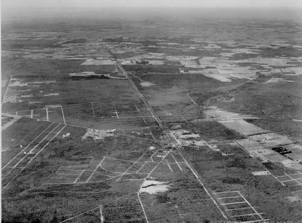
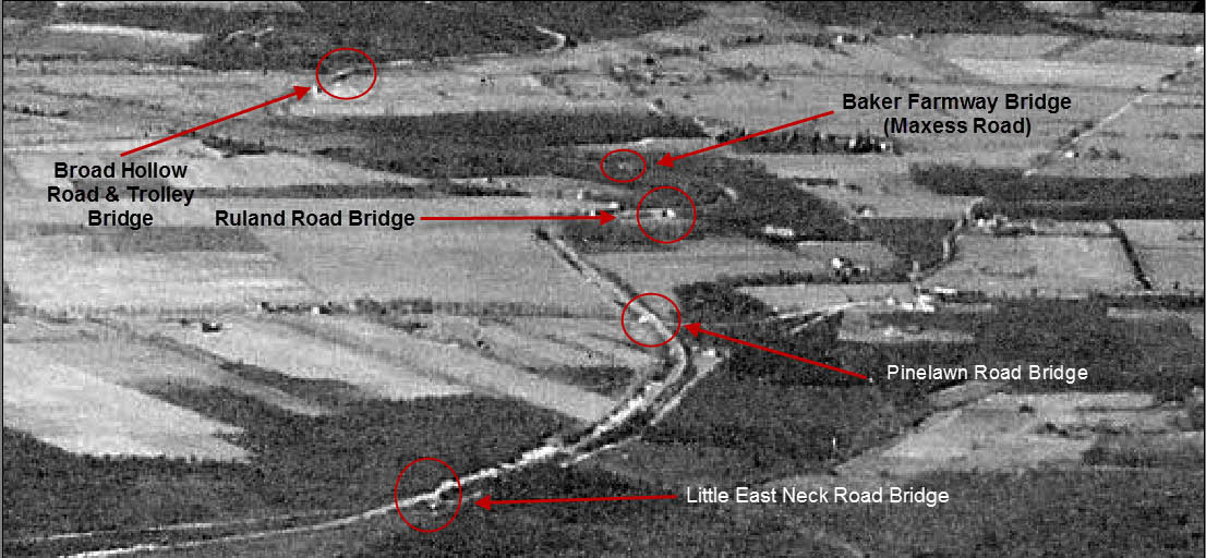
This previously unpublished 1930 aerial shows the Motor Parkway near Colonial Springs Road in Wheatley Heights looking west.
Congrats to Greg & Dee, Frank Femenias, Brian McCarthy and Steve Lucas for solving the Mystery Foto.
Answers to the Mystery Foto questions:
-How many Motor Parkway bridges can be seen or barely seen in the aerial?
-Colonial Springs Road Bridge (parkway)
-Little East Neck Bridge (parkway)
-Pinelawn Road Bridge (parkway)
-Ruland Road Bridge (parkway)
-Baker Farmway Bridge (Maxess Road)
-Broad Hollow Bridge (parkway/trolley)
And even some Old Bethpage and Bethpage bridges in the background.
-What are the other landmarks in the aerial?
-Fairchild Flying Field in East Farmingdale, later to become Republic Aviation in 1939
If you have a suggested Mystery Foto, please send a jpeg to me at [email protected]
Enjoy,
Howard Kroplick
.
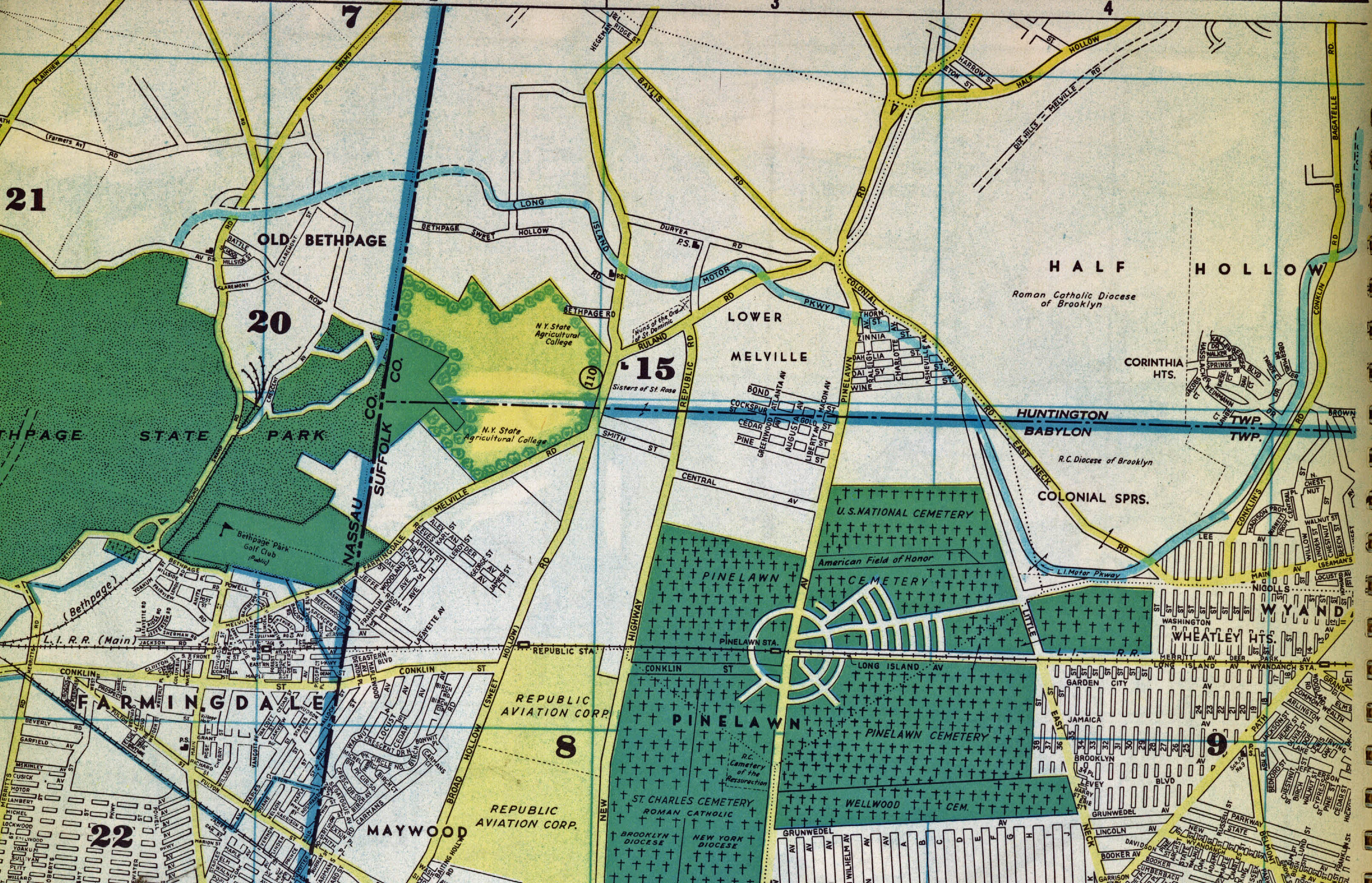
1952 Map
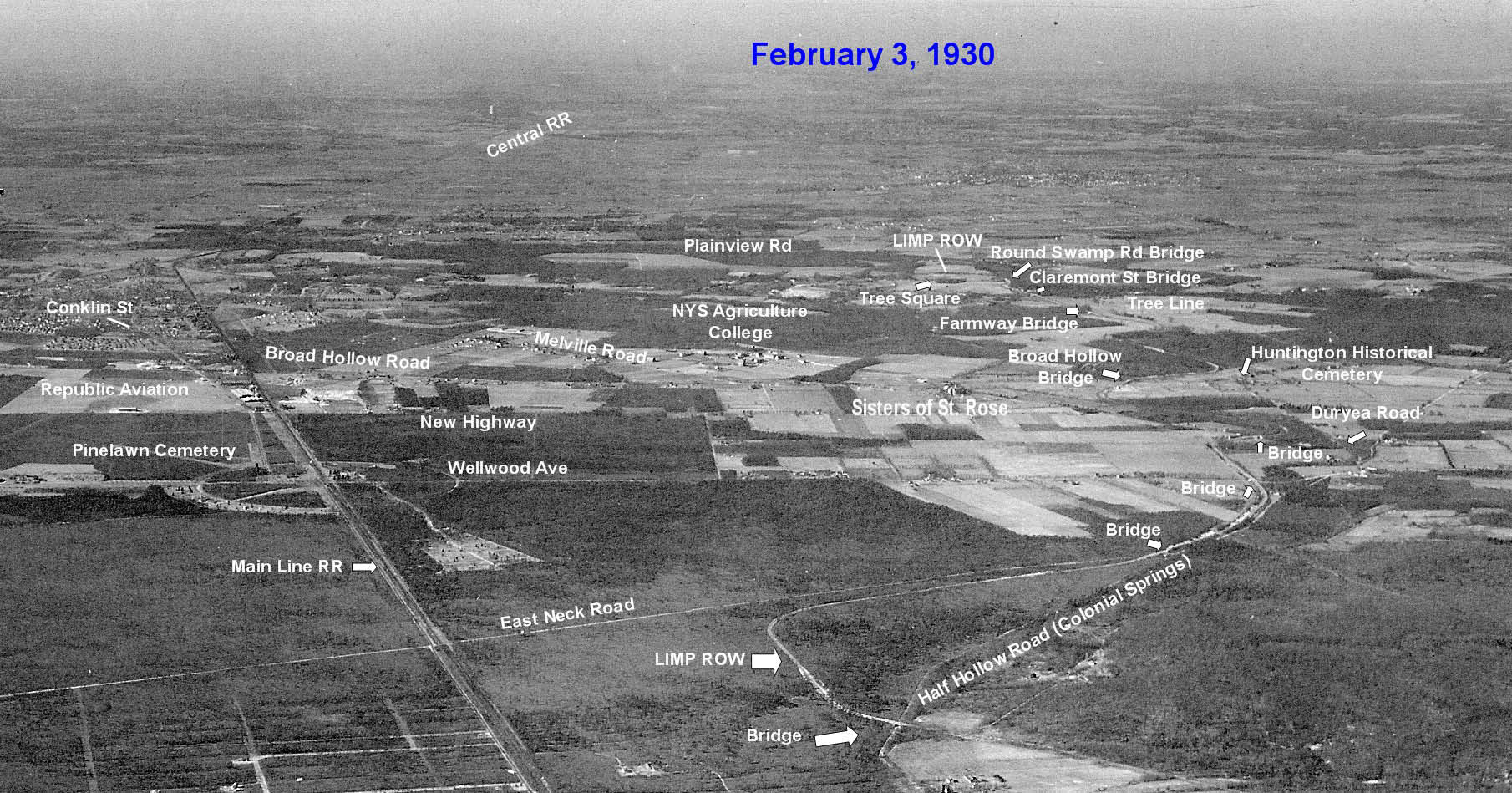
Close-Ups of the Aerial
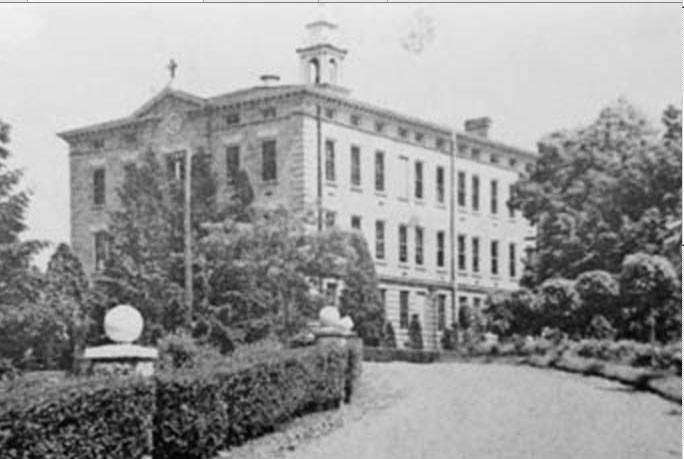
Black and white photograph of the St. Rose Industrial School for Girls, built in 1907 by the Dominican Sisters. Situated on Route 110 in lower Melville, the bell in its belfry rang loud and clear at 6 a.m., noon and 6 p.m. for all to hear. Courtesy of Half Hollows Hills Community Library.
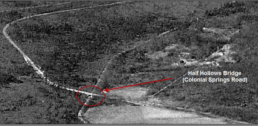
Colonial Springs Road Motor Parkway Bridge
The Motor Parkway was located on top of this bridge.


Comments
This area of the motor Parkway appears to be in the Colonial Springs / Pinelawn / Melville vicinity looking west. I believe I can see bridges at Colonial Spring Road, Little East Neck Road, Pinelawn Road, and Ruland Road. I think I also see some early buildings that later became part of Republic Aviation.
This a westerly view of Wheatley Heights. The LIMP is evident in the upper right of the main aerial. I see 4 parkway bridges. Colonial Springs Rd, Little East Neck Rd, Wellwood Ave, and Ruland Rd. Just past Little East Neck Rd, the LIMP and Colonial Springs Rd are almost on top of each other. If this is of any interest to anyone, I remembered a railroad siding on a Historical Aerials 1945 topo map in this area. The sidings came off the main line near Wyandanch Station n( 1 still exists, it runs across Merritt Ave, and deadends w/o 18th st ‘Amerigas’. I don’t know if it’s utilized. The other siding used to curve west towards 23rd st, and then pretty much follow ed north , and according to the topo map; it interesected the LIMP as far as present day Oxford Ct. But then on a 1915 Belcher Hyde map, the spur deadended at the intersection of Nicolls Rd and 23rd st. So who knows if this spur was encountered with the construction of the LIMP in this area. It would be interesting if it did.
Wheatley Heights/Wyandanch looking west. Future sites of Pinelawn/LI National Cemeteries and USDAN in the center, many LIMP structures visible here, this aerial is fortified with all the essential vitamins and iron. East to west Colonial Springs Rd pkwy bridge/Little East Neck Rd pkwy bridge/Pinelawn Rd pkwy bridge/Ruland Rd pkwy bridge/Baker-Maxess Rd farmway bridge/Broadhollow Rd pkwy bridge. Clody-Sandpits farmwy bridge is off the photo at top. Republic Airport is off the photo to the left. Can’t see the Huntington lodge, being elusive again. Is it possible the Huntington lodge was replaced with a kiosk to make room for U-turners using the round trip tickets? Is that Edith’s farmhouse at the very top, off center left, just south of Ruland Rd?
We are looking West at the Wyandanch Rail Road station in the lower front and center. The Motor Parkway section by the curve is the portion that is in between Colonial Springs Rd and the National Cemetery. You can see where the Babylon Lodge would have been, and bridges in the area should be at; Colonial Springs Rd, Little East Neck Rd, Pinelawn Rd, Ruland Rd, Baker farmway bridge (Maxess Road) and finally the Huntington Lodge if you zoom in…
Wow!! How observing you all are. I know of all these areas,but would never have found what you people did. This is all around the Newsday Building and the Post Office,right? that where I used to work,as I mentioned in an earlier comment. Everything I’m learning from you guys I never knew about until know and want to help you all preserve as much as we can
As to Mr. McCarthy’s reference to the various sidings ooff the LIRR mainline, I recall there was an extended “Y” going North off the LIRR at the East end of Republic running along Repoublic Road, which Y eventually served as the “turn-around” for trains terminating at Republic (East Farmingdale). Also, for information, I recall some of the older farmers referring to that “siding” as serving farmers in the area, calling the Central Branch with which the Main Line connected at Bethpage as the “Manure Line”.
Thankyou, Edith. We’re all fortunate to have you interested in these topics.