Mystery Friday Foto #40 Solved: A 1941 aerial over Hollis Hills, Queens
Did you identify this weekend's Mystery aerial?
Answers to the Mystery Foto questions
Identify:
- Location and orientation of the photographer
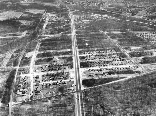
Looking east over Hollis Hills/Fresh Meadows section of Queens
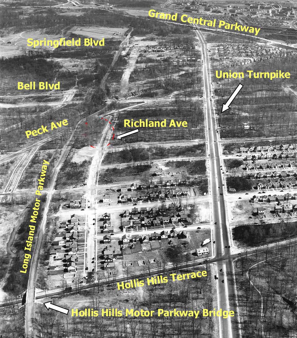
- The major roads
See captioned aerial below.
- The Motor Parkway structures
Bridges (4): Hollis Hills Terrace, CRR/Parkway, Springfield Boulevard and Grand Central
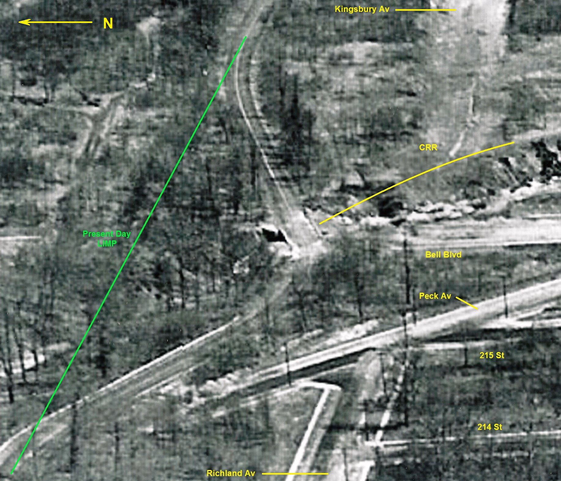
- The railroad right-of-way
The Central Railroad Motor Parkway Bridge
- The approximate date of the aerial and rationale
March 26, 1941. Rationale: Motor Parkway was closed. Rocky Hill Lodge was demolished. The housing development still being built in Hollis Hills.
Comments (9)
Congrats to Kevin Meaney, Al Prete, David Miller, Steve Lucas, Joe Oesterle, Roy Warner, Frank Femenias, Brain McCarthy and Gene Perry for correctly IDing the Mystery Foto. 100% of the Comments!
Kudos to Frank Femenias and Brian McCarthy for their photo documentation.
Enjoy,
Howard Kroplick

This aerial was first posted on August 1, 2011..over 11 years ago. Times does fly when you are having fun!
Central Railroad Motor Parkway Bridge. Courtesy of Frank Femenias.


Comments
That is Hollis Hills/north Queens Village, facing East. The parkway is to the north, the main road in the center of the photo is Union Tpke. You can see the original Creedmore facility in the distance.
Looks like the western section of the LIMP in the Hollis Hills section of Queens. The photographer is looking east.
Major E-W roads, LIMP, Union Tpke., Hillside Ave. Major N-S roads: Hollis Court Blvd., Bell Blvd.
I see the LIMP overpass over Hollis Court Blvd. at lower left. The RR ROW crosses the LIMP at upper left, near the jog in the parkway.
Approximate date: 1940, because the parkway appears to be abandoned but the bridge is intact, and there’s not a lot of development in the area.
The photographer is facing east, hovering over Hollis ct blvd in the foreground which is running horizontally at the bottom. The dominant road in middle of the photograph running from top to bottom is Union tpke. Bell blvd is in the middle running left to right and intersects the Long Island Motor Parkway where the parkway curves a little. The Long Island Motor Parkway is on the left running vertically from top to bottom. You can clearly see its overpass still intact going over Hollis ct blvd on the bottom left. Other LIMP overpasses are not easily identifiable and may no longer be in existence when this picture was taken. That diagonal right of way where the LIMP and Bell blvd form a triangle is the old Central railroad of Long Island. The existence of the Grand Central Parkway at the top of the picture dates it after its opening in 1933. Also, the condition of the LIMP near Richland ave and 210th st (middle left side of picture) doesn’t look so good. It looks ripped up. So this dates the photo after the parkway’s closure in 1938. So I’ll just guess and say the picture was taken around 1940. This was a tough one for me but when I saw the Alley Pond Trackfield on the upper left part of the picture I knew I nailed it.
The photographer was over the Fresh Meadows / Hollis Hills area of Queens looking east. Major roads include Grand Central Parkway, Springfield Blvd., Union Tpke., Hollis Hills Terrace, Bell Blvd., and of course the LIMP. Structures include LIMP bridges over Springfield, Bell, Hollis Hills Terrace and under GCP (hidden). Hard to see but the toll lodge at Springfield Blvd. might be there also. Bell Blvd. was built on top of the old abandoned Central Railroad R-O-W. Since the LIMP appears to not have any cars on it and Union Tpke. looks like it has been completed, I’ll place the date around 1941.
Queens. Union Tpke is center. LIMP is lower left, heading east. Hollis Ave bridge, the swerve at the old railroad tracks, (today’s Bell Blvd). You can see the spot where the tolls used to be at Springfield Blvd. The Grand Central passes over Union Tpke. Making this picture most likely in the late 1930’s/
Just a guess. But it looks like where I used to ride my bike on the Vanderbilt Parkway from Fresh Meadows to Creedmor in the late ‘50s and early ‘60s.. Looking eastbound from just west of the parkway bridge over what was then Hollis Court Blvd. The GCP is visible to the right, which cuts across Union Turnpike, which is just south of the Vanderbilt. The picture must have been taken before the War, given that the lands along Union Tpke haven’t been built out yet. However, I’m probably wrong because I don’t remember the curve and running track.
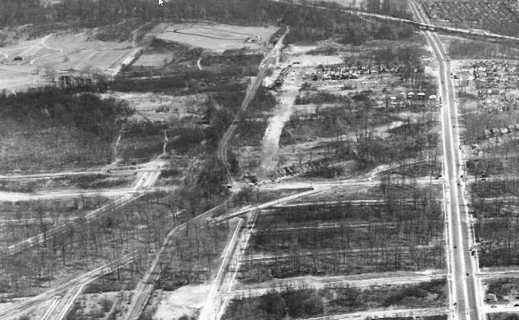
Neat never-before-seen photo of Motor Parkway stretch between Alley Pond and Cunningham Parks looking east. This section is currently being resurfaced with completion expected next summer.
Major roadways:
From bottom;
Hollis Hills Terrace (Queens Rd), Bell Blvd, CRR RoW, Springfield Blvd (Rocky Hill Rd), Grand Central Pkwy, Winchester Blvd.
From left;
Motor Pkwy, Richland/Kingsbury Aves, Union Tpke, 82 Av, 85 Av.
Motor Parkway structures;
Hollis Hills Terr parkway bridge (1926-present), CRR parkway bridge (1926-1944), Springfield Blvd parkway bridge (1924-present), Wheeler Farmway west bridge (hidden under the Motor Parkway).
Date;
The CRR bridge (1926-1944) appears intact. The Rocky Hill Rd Lodge (1928-1940s) appears removed. The race track north of the Rocky Hill Rd Lodge existed in 1938.
The newer Winchester Blvd bridge (1932-1940s) after Union Tpke expansion appears to follow the new LIMP RoW in the photo.
With new Hollis Hills housing sprouting up in the photo (1935+ [most in the photo are 1940s]), I’d guess the photo date is very close to 1944
Fantastic photo Howard, thanks for sharing!
This is in Queens, NY. Aerial photographer was looking East. Know there’s the Farmway Bridge East of Springfield Blvd, near the Bungalow Lodge Home. Then the Parkway Bridges at Springfield & Bell Blvd ( curve where the RR abutments were utilized ), then at Hollis Ct. Guess this is about 1942. Toll Booth East of Springfield Blvd looks to have been removed. The present day Bell Blvd Bridge and the straightened bike path hasn’t been created yet. Think that was done around 1950?
This view is looking East on Union Turnpike from Bell Blvd. The Motor Parkway is on the left side. You can see the old S route of the LIMP before the city built the new bridge at Bell Blvd. I always wondered what was the oval track just east of Springfield blvd bridge on the left.Howard, would you know? Thanks,Gene