Mystery Foto #38 Solved: A 1951 aerial of the Motor Parkway in Fresh Meadow, Queens

Frank Femenias challenged you to identify this weekend's Mystery Foto.
Answers to the Mystery Foto questions
Identify:
- Location and orientation of the photographer
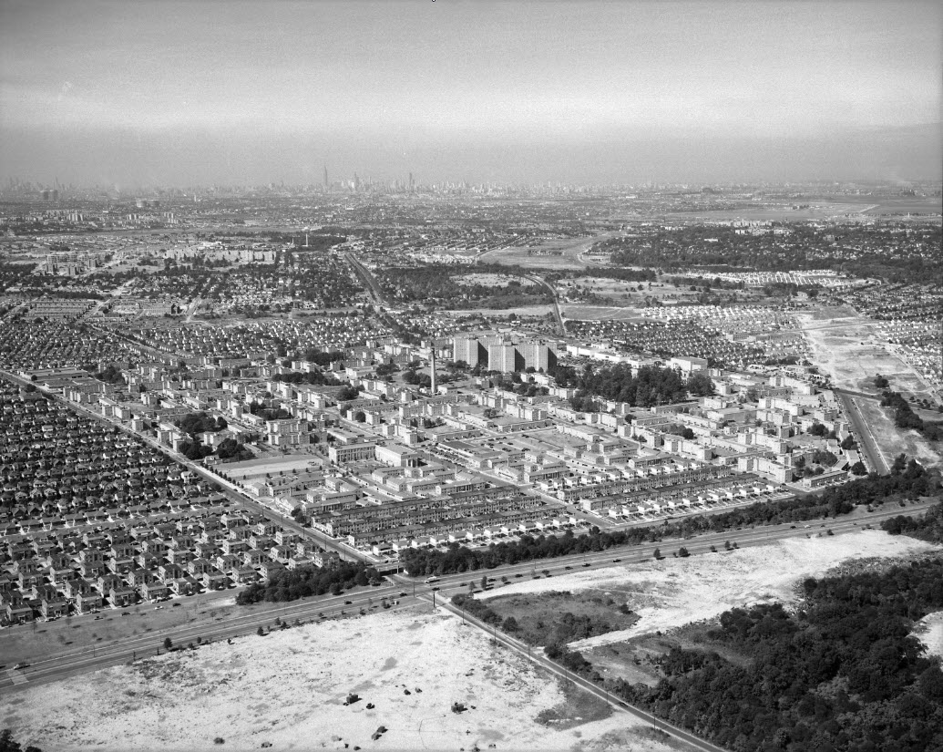
Fresh Meadows, Queens, looking west towards Manhattan
- The year of the Foto. Provide a rationale.
September 5, 1951. Rationale: Cunningham Park development has just begun to be built. Long Island Expressway has not been built.
- The Motor Parkway
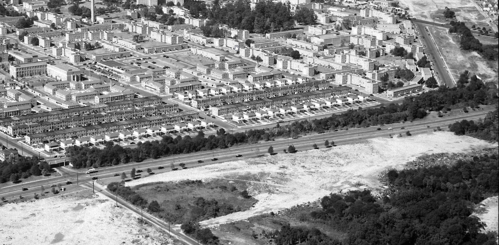
Thirteen years after it closed, the Motor Parkway can be seen diagonally going north/south (left to right.)
- Motor Parkway structures (at least two)
73rd Avenue Motor Parkway Bridge and remnants of the North Hempstead Motor Parkway Bridge
- Major roads and landmarks
Skyline of Manhattan including Empire State Building. See other landmarks in the Comments including the Elmhurst Tanks.
Comments (13)
Congrats to Joseph Oesterle, David Miller, Steven Swirsky, James Dale, Roy Warner, George Philippides, Alan Wunner, Steve Lucas, Art Kleiner, Mark Lanese and Brian McCarthy for identifying the 1950s aerial over Fresh Meadows.
Kudos to Roy Warner for providing Fresh Meadows background from the 1950s.
Greg O. & Howard Kroplick
Close-Ups
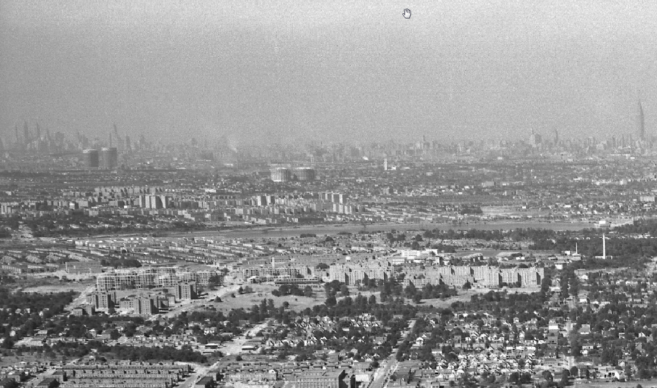
Traffic was moving slow at the Tanks.
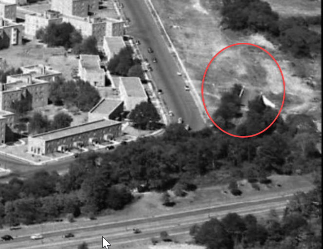
Remnants of the North Hempstead Turnpike Motor Parkway Bridge


Comments
Queens, looking towards Manhattan. LIMP Bridge over 73rd Ave. Francis Lewis Blvd is the main road parallel to the LIMP. From left to right, and you would be heading north. The western end of the LIMP is up to the north.
We are facing west with the 73rd ave (black stump rd) bridge in the lower center of the picture. The second Motor Parkway feature in the photo is the North Hempstead Turnpike bridge shown on the far right. Francis Lewis blvd runs parallel to the parkway here. In the foreground is Cunningham Park but it looks like its a bit of a mess still. No ballfields yet. I can’t find the Long Island Expressway in the picture so I’m going to guess the date to be between 1950 to 1955.
Early view of Fresh Meadows. Looking west northwest. Francis Lewis Blvd in the foreground crossing 73rd Avenue I can see PS 26 school yard on 73rd then the Klein farm, then blocks of garden apartments. Motor Parkway right of way is in the tree line parallel to Francis Lewis. Tall buildings in Fresh Meadows are the 13 story buildings. East side of photos show what were later little league fields I would put this around early 1950s. Motor Parkway bridge over 73rd Ave and one where Bishop Reilly was built around 64thAve are both visible.
Francis Lewis Blvd and 73rd Ave, pre-I 495 (Horace Harding Blvd there), with Peck Ave between the two.
Again where I grew up in the 50s - Fresh Meadows, although I lived on the other side of Horace Harding Blvd on 199th St. and 51st Ave. View is looking Northwest. Major roads are Horace Harding Blvd and Francis Lewis Blvd. Significant roads are 73rd Ave, with the Motor Parkway Bridge going over it. Peck Avenue, which parralleled the very end of the Motor Pkwy where it met Horace Harding Blvd. I also can see the “cut off” Motor Parkway bridge over the “cut off” North Hempstead Tpke. The year of the photo was probably about 1953. The vacant areas east of the intersection between Francis Lewis Blvd. and 73rd Avenue (they eventually became part of Cunningham Park where baseball diamonds were laid out) was the site of a National Guard outfit (the southeast area). However, I don’t see any buildings or vehicles at the site, which must have before 1955. And from my memory, PS 179 opened in 1955. So, if my memory is correct, and considering that it would have taken one year to build it, the photo had to have been taken before 1954. Unfortunately, my house was just “east” of the righthand side of the photo, which doesn’t show 199th St. at the point where it was parallel and one block west of Francis Lewis Blvd.
I believe this aerial is taken over Cunningham Park in Fresh Meadows looking west.
Date is 1940s since Francis Lewis Blvd is present
The motor parkway is running north-south just east of Francis Lewis Blvd , most of it lined by trees.
Can only ID one MP structure, the 73rd Ave Bridge
Major landmark is Empire State building in distance
Looks like the Fresh Meadows area with Francis Lewis Boulevard,73rd Avenue,and a small tree-shaded remnant of the Motor Parkway with the 73rd Street bridge visible. It is hard to see the LIE in the area of the Francis Lewis B’lvd interchange although you can see it off towards the northwest. No sign of Bishop Reilly HS yet. I would guess late 1950’s/1960.
Looks like we’re over Cunningham Park looking west with the freshly built Fresh Meadows apartment complex in the center. The date should be about 1950 since the L. I. Expressway construction hasn’t been started yet and Cunningham Park development north of Union Turnpike has just begun. The LIMP runs left to right following the tree line with the 73rd. Avenue and North Hempstead Turnpike bridges visible. Other major roads include Francis Lewis Blvd., Horace Harding Blvd., Peck Avenue and Hollis Court Blvd. As to landmarks, I think I see the Elmhurst Tanks and possibly the Chrysler and Empire State Buildings.
Fresh Meadows, Queens looking west
Late 1950s during LIE construction and after the tower/incinerator next to the tall buildings were built
Motor Parkway is in the trees running across the bottom of the photo
North Hempstead Bridge, 73rd Avenue Bridge
Francis Lewis Blvd., Horace Harding Blvd., Union Turnpike
The photographer was over present day Cunningham Park and/or Clearview Expressway. Picture was taken before construction of the LIE so probably late 40’s early 50’s.The LIMP is crossing over 73rd Ave. running parallel to Francis Lewis Blvd.
I marked up the birds eye view aerial below with road names etc. Photographer was facing Northwest in Queens NY, guessing 1950; no later than 1955. 2 landmarks for the LIMP? Parkway itself, bridge over 73rd Ave. From what I can tell. the N Hempstead Tpke bridge has been removed, but I noted on the map where it was located.
From Greg O.
Elmhurst gas tanks off in the distance
Oh-no, there goes the tanks!! Great pic Greg!
Sorry I missed this one! Brian McCarthy’s markup is very good, but that is not North Hempstead Turnpike. That’s the LIMP from HHB to NHT. The NHT angle was different…it went throught the Oak Grove, the woods to the upper right, just above the “N” in your label “North Hempstead Turnpike”. NHT was gone by this time. So the dotted line showing the path of the NHT was also not correct.
Correction to my comment above. That is not “the LIMP from HHB to NHT”. That was Peck Avenue, built after that section of the LIMP was taken down. The LIIMP was a little to the east of that road, but basically ran parallel.
Oh wait! Greg, I don’t remember the Elmhurst tanks being checker-board on top.
Frank- You are correct! My mistake for just quickly snagging an improperly captioned Google photo. The tanks in the demo photo were on Maspeth Ave in Greenpoint and not the Elmhurst tanks. Good catch!
Thanks, Mitch. I remember you followed the late Sam Berliners History websites ( he had quite a few interests ) There’s a Mystery Foto #2 - Jan 15 2018 - Fresh Meadows, that has excellent views of this area; around the same time period. Nice mix of the old & new then. Below is a screenshot looking Southeast.
What happened to the old North Hempstead Turnpike? Sources that I found say it was renamed to Booth Memorial Avenue, but Booth Memorial Avenue ends at the Horace Harding Expressway north service road. How far east did the old turnpike go?
Al, found on an older map that NH Tpke stretched east to Hollis Court Blvd; which I think used to be Queens Rd.
Al Prete - A snapshot from the online Motor Parkway map. You are correct about N Hempstead Tpke being renamed as Booth Memorial Av. The tpke’s eastern terminus at Hollis Ct Blvd was removed to make way for housing in Fresh Meadows 1951, and later for the Clearview Expwy in 1963. The rest of the old tpke still remains as Booth Memorial Av
Thank you Brian and Frank. I wonder why it was called “North Hempstead Turnpike” when it was nowhere near Hempstead or the Town of North Hempstead.
Al Prete - to add more confusion, here’s a 1906 Nassau County map naming Northern Blvd as “Flushing and N Hempstead Tpke.”
NHT was named for the intended final destination of drivers, a 19th century practice. That is also the reason for the 1906 map labeling. Today’s Northern Blvd was a road of many names and part of Northern was signed as a second NHT, a shortening of the 1906 name, even in my lifetime. Circa 1964, NHT (the first) was renamed in honor of Booth Memorial Hospital (now NY-Presbyterian Queens) to end the confusion.
The intersection of NHT and Queens Road was a significant intersection and part of the way to the Town of North Hempstead in a way that would not be obvious on modern maps but which can be deduced by the 1924 illustration of the planned “Nassau Highway.” That illustration also labels part of Northern as Broadway and visually reveals the logic for originally planning to end the LIMP extension at Black Stump Road (73rd Ave).
Nassau Blvd made the eastern end of NHT obsolete (and NHT/Hollis Ct intersection is shown deprecated in a 1932 Hagstrom map). NYC demapped this eastern end because of its too narrow right-of-way and because Francis Lewis Blvd. had overlaid part of the road.
Part of NHT was obliterated when the FM shopping center was carved out of a hillside over which NHT ran. Other parts were destroyed for the FM street grid. But the actual NHT/Hollis Ct intersection still exists in the woods of Cunningham Park!
David, thank you for clarification.