Kleiner’s Korner: Part 3 - Motorcycle Races on the Motor Parkway
In addition to the Vanderbilt Cup Races, the Motor Parkway was used as a race venue by local motorcycling enthusiasts. Various clubs found the roadway to be an excellent choice as its length and not having grade crossings made it a suitable route. Documentation is from various issues of Bicycle World and Motorcycle Review between 1909 and 1911.
Art Kleiner
1909 & 1910
The first race on the new Motor Parkway was run on October 16, 1909 following investigation by club officials.
1910: Races of various lengths were held for different sized motorcycles. The length of the race might have been determined by the length of completed roadway.
1911
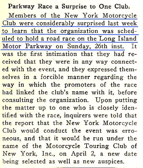
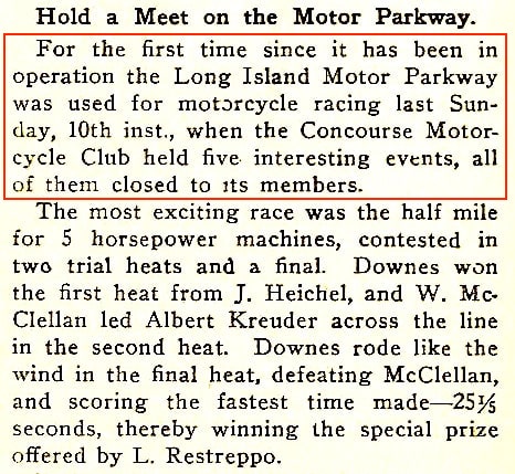
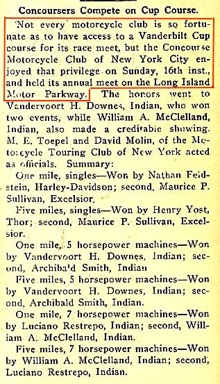
Unbeknownst to The New York Motorcycle Club that was supposedly coordinating the race in 1911, a date was scheduled for March 26. The club eventually agreed to host the race, however changed it to be run under the name The Motorcycle Touring Club of New York, Inc.
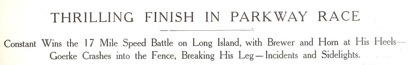
The race was held on Sunday, April 2, 1911 and consisted of 17 miles.
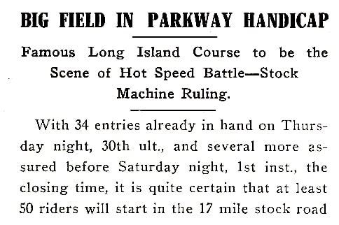
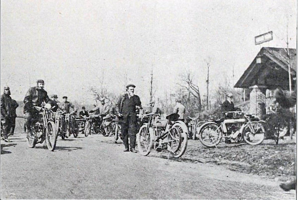
Approx. 50 cyclists entered.
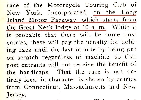
The Great Neck Lodge, the parkway's western terminus at the time, was selected as the start of the race which began at 10 am.
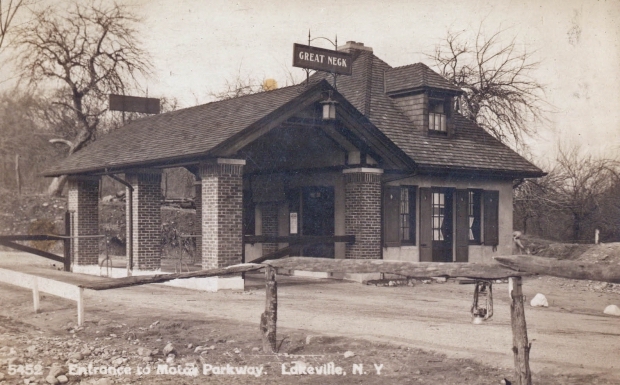
Great Neck Lodge (1911)
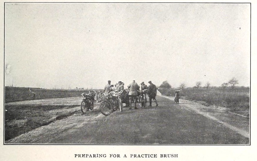
Cyclists were able to test out the course before the race.
Can anyone identify the Motor Parkway Bridge in the background?
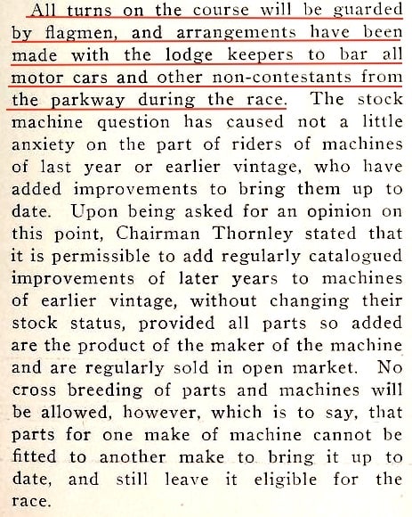
Flagmen were used on all curves and lodge keepers were asked to keep all non-racing vehicles (including motor cars) off the parkway during the race.
Straightaways probably made the parkway advantageous to race on.
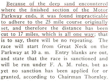
Originally the race was to be 25 miles in length, however the condition of "deep sand" at the 25-mile mark caused it to be shortened to 17 miles.
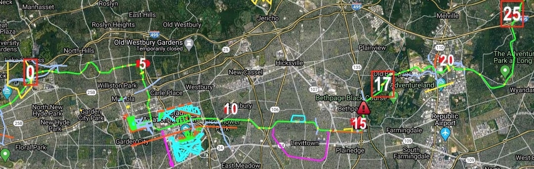
On Frank Feminias' map which shows Motor Parkway mileage, I've set Lake Success, the starting point, at 0 and re-calibrated the map. Bagatelle Road would be near the original end point of the race, however after shortening to 17 miles, it appears to have ended near today's Adventureland or Bethpage State Park.
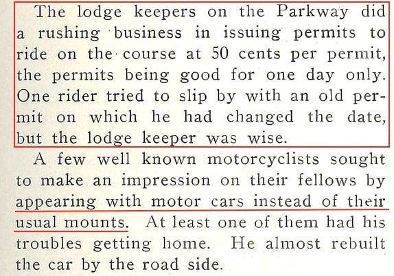
Lodge keepers issued daily permits to the cyclists at a cost of $.50, one tried to sneak in with an old permit but was caught. According to Motor Parkway expert Al Velocci, the permit increased in cost to $1 in March, 1923 as a possible disincentive since accidents between autos and motorcyclists were occurring too frequently.
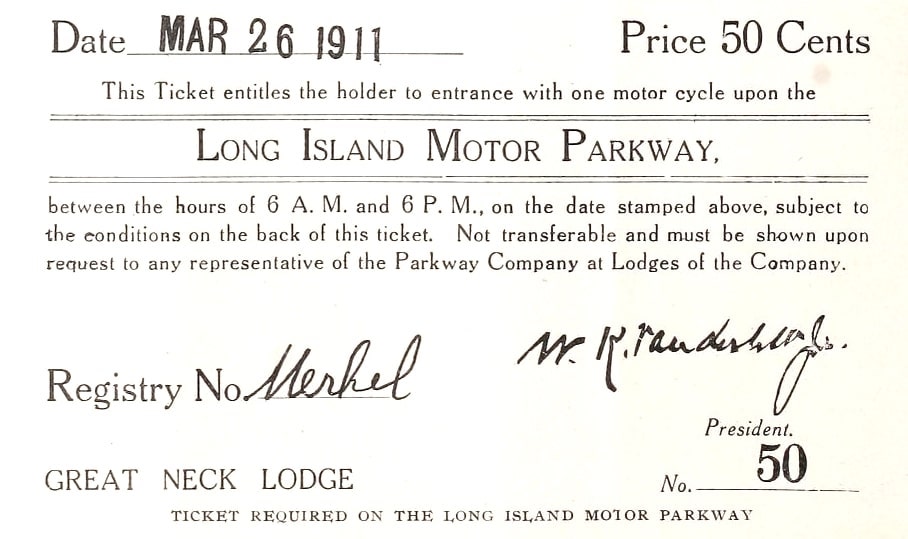
This permit was issued on the original race date - wonder if the lodge keepers provided refunds or exchanges. Note Willie K.'s signature. The holder of the permit, Merkel, refers to Joseph Merkel, a prominent motorcyclist and manufacturer (i.e., The Flying Merkel).
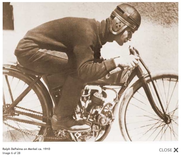
Ralph DePalma, winner of the 1912 and 1914 Vanderbilt Cup Races, was originally a bicycle and motorcycle enthusiast (as other auto drivers were also) - here he is on a Merkel motorcycle.
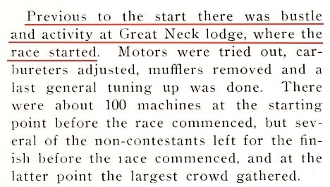
As race time neared, many of the non-racers left the Great Neck Lodge and went to the finish line.
Great Neck Lodge on the right.
The Motor Parkway bridges provided a good viewing point for the fans.
The obstacles of "S" curves and sightless views approaching bridges warranted caution. This became reality when one participant (Walter Goerke) was injured. He suffered a broken leg but recovered.
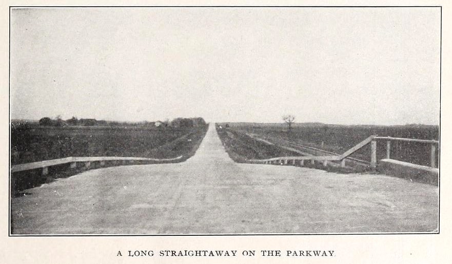
Nice picture showing a straightaway after leaving a Motor Parkway bridge.
Can anyone identify where this photo was taken?
Throughout the Motor Parkway's existence, other races were held which will be documented in Part 4 of this series.


Comments
I’ll guess on the bridges…the upper bridge photo is taken from the West side of the Old Courthouse bridge looking East.
The lower photo I think was taken by a photographer on top of the Hicksville-Massapequa bridge looking East with the Stewart Ave-Jerusalem Rd bridge off in the distance.
Art, Found the letter that Kienzle sent to the lodge keepers about motor cycles. It’s dated Mar. 15, 1923 and states the motor cycle rate is increased to $1.10 effective immediately. ( the 10 cents is a “war tax” put in place in 1918.) Shortly thereafter motor cycles were banned from the Parkway because of an” unauthorized race that blocked automobiles” Can place the date exactly but on the Daily Report of Toll Lodge Receipts forms, in late 1923, the motor cycle column is no longer there.
Art I think the second photo was taken from the Old Westbury Rd./Gasser Ave. Bridge looking east. In the distance, on the left, the treed area, is where the New Bridge Hotel at New Bridge Ave. was located.
Art, the first photo, Me thinks the bridge in the distance is the Smith farmway bridge (Art to Al) Why.? If they are starting at the Great Neck Lodge, would they not gather in the vicinity of the lodge? Also, look at the condition of the roadway ,not very good, at that time that part of the Parkway was just being developed. (Art to Al) Very good, brilliant in fact, you are probably right, Howard is going to give you one of his duplicate motor parkway plates as a reward.
Al, my thought was the Smith bridge as well, but surrounding foliage at the Smith bridge does not seem to fit the motorcycle photo. Also, why gather the motorcycles and not be on the LIMP?
From Art Kleiner:
Good comments, Al and Greg - sounds reasonable to me! Also like the two way conversation, Al - guess you’ve been reading my mind, as well as my blogs!.
And about the motorcycles being banned on the Motor Parkway, as you’ll see in my upcoming Part 4 of this series I couldn’t find documentation after 1920 relating to races. So the ban had to be the reason.
Gentlemen, the first photo “Preparing for a Practice Brush” I believe is looking west with all shadows pointing north. The flat landscape better matches early Old Courthouse Rd than the high-treed landscape of Smith farmway bridge (Great Neck). Not sure but looks like a roadway (on the left) connected to the bridge, not a farmway bridge. Another possibility Jerusalem Ave bridge looking west in Levittown.
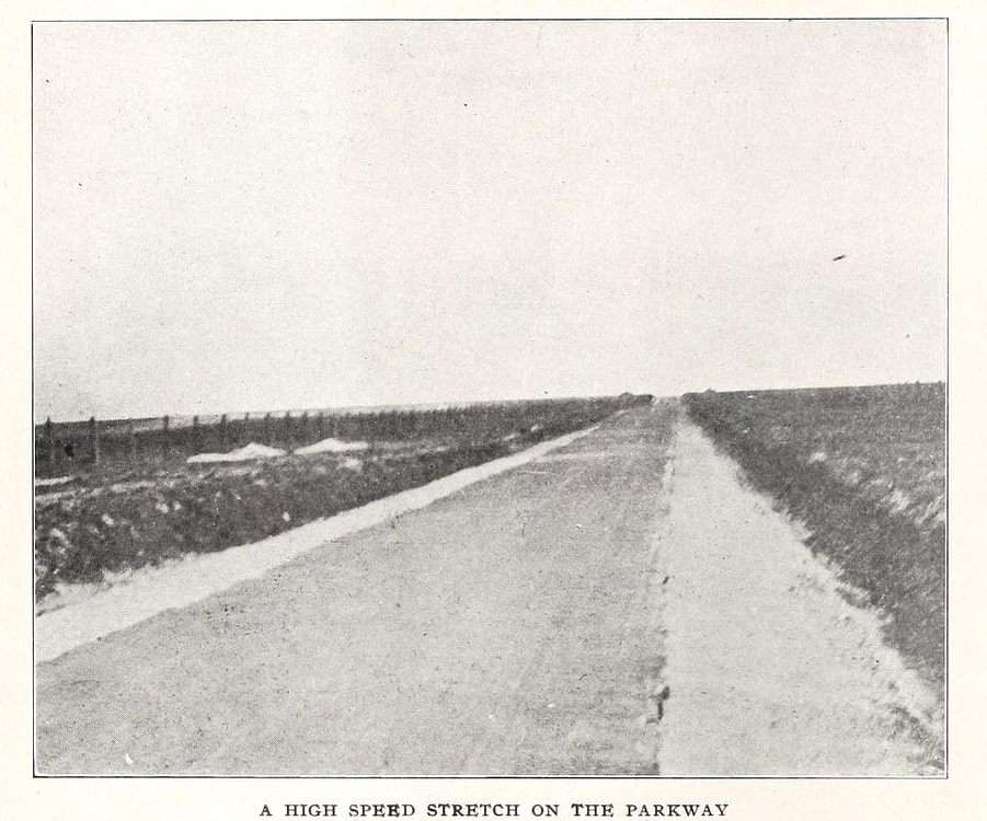
The “High Speed Stretch on the Parkway” could be just west of the Stewart Ave bridge (Bethpage), and looking west towards the Hicksville Rd bridge (Levittown) in the distance. The CRR is fenced off on the left side, and the Ground Breaking Ceremony site on the right.
The “Long Straightaway on the Parkway” I agree with Al, Old Westbury Rd looking east towards the Newbridge Rd bridge in the distance (pre Wantagh State Pkwy bridge), with CRR on the right. But a longer straightaway could be between Universe Dr. and Dead Man’s Curve, looking east towards N Wantagh Ave bridge (Levittown) with CRR on the right side.
The head photo on top looks like a belt driven motorbike at center. Great post Art
Correction:
The “Long Straightaway on the Parkway” I agree with Al, Old Westbury Rd looking east towards the Newbridge Rd bridge in the distance (pre Wantagh State Pkwy bridge), with CRR on the right. But a longer straightaway could be between Universe Dr. and Dead Man’s Curve, on top the N Wantagh Ave bridge (Levittown) looking east towards the Hickville Rd bridge (1100 ft / 0.2 mi) with CRR on the right side.
Frank, the reason why I said it was possibly the Old Courthouse bridge looking towards the East rather than the West as you claim is the tree line, and what little we see of it. Below is my comparison photo of the OCR bridge looking (as we know from the cut-off photo caption) West towards Great Neck. My crude arrows point to trees that in my view match up but in the opposite direction. OCR bridge has some of the flattest embankments
Greg, Your bottom photo, the one with 2 blue arrows and one black arrow on the left side of the photo, wasn’t that photo taken from the New Hyde Park Rd. bridge looking east ?
Greg - I see your point! Now I’m not sure if those are shadows by the motorcyclist and their bikes, but the top photo by the Great Neck lodge clearly show shadows on that sunny day.
Al - the parkway just east of Old Courthouse has similar curves heading eastward; after the bridge, first a slight left curve followed by a gradual right curve. If memory serves, I believe Greg’s photo came with a front caption but with limited location info
Frank, If that is the case, we are looking west from the Shelter Rock Rd. bridge?
Al, Frank, here is the full-frame of the OCR bridge. This is from the Petit Trianon postcard series. The caption describes it as looking west towards Great Neck.
Al - Yep, that’s it! Photo taken from about halfway point between Shelter Rock Rd and OCR. Thanks Greg. I’m almost convinced those bikes and riders are casting shadows all over the roadway, especially that bike on the right. And what’s up with that clean cut wide shoulder on the left? It almost appears like a rest stop for LIMPer’s.
Frank- I’m kidding, but it looks like that wide shoulder is still there to this day!
Yes, that was close Greg. I’ve been wanting to simulate your OCR bridge photo for some time, but need a camera drone to snap the photo.. Anyone with a drone interested in such a project?
The reasoning for the ‘sand condition at the 25 mile mark’ is clearly explained below.