A 1946 View of the Broad Hollow Motor Parkway/Trolley Bridge in Melville
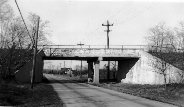
My favorite co-author has provided this never before published 1946 photo of the Motor Parkway bridge over Broad Hollow Road and the Cross Island Trolley.
The bridge was built in 1910 over the road originally called "Highway from Melville to Amityville". It is better known today as Route 110.
The narrow section on the right was built to accommodate the Cross Island Trolley line that once ran between Babylon and Huntington Village and ceased operations in 1927. The trolley's utility poles were still standing 18 years later.
Enjoy,
Howard Kroplick
1945
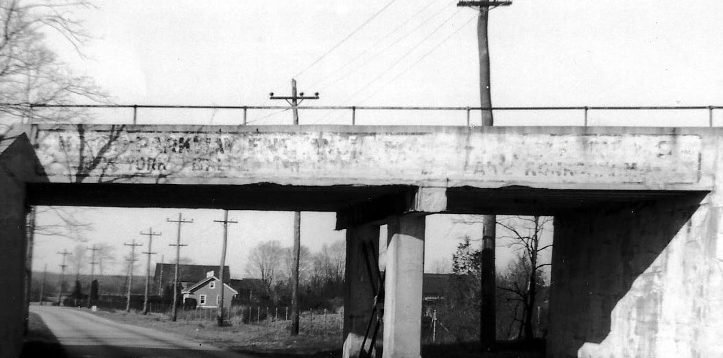
Copy on the bridge was fading away seven years after the Motor Parkway closed in 1938.
Forensic analysis of the copy reads "MOTOR PARKWAY ENTRANCE.....NEW YORK......LAKE RONKONKOMA"

The view is looking north
1935
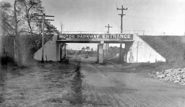
The same view seen 10 years earlier when the Motor Parkway was still active.


Comments
Excellent image! Probably the last image of this bridge before it was bulldozed.The bridge sign in 1935 must have been removable, the original painted copy being covered over. Also see that the electric utility strung wires along the trolley poles. Telegraph/Phone on the west side.
Amazing how this LIMP area on Rt 110 has changed over the years; first with the bridge’s removal, then with consequent road expansion. The bridge photo is unrecognizable today
The blue line in above photo is the center of former Highway from Melville to Amityville (Old Rt 110). The yellow line is the former Broad Hollow bridge. Could the current telegraph pole standing on the west side, be the same location as shown in 1945, and also in 1938? Their locations are very close.
Here’s the same location viewing south, Frank. Definitely the same pole line row.
With respect, but isn’t the blue line the present multi-lane Route 110; whereas, the old Route 110 starts near the Church in the Wildwood and then winds itself to finally come out near the junction of the new 110 and PineLawn Rd… or has age finally failed to catch up with memory (new 110 being the same as the former Cross-Island Trolley line)?
caught up ?whioch nows runs to Mr McCarthy…
Believe Vincent Seyfried had a similar view in his book on the Huntington Trolley. This a great shot!
Am on short rations with e-mails until Queens Library reopens to public with computer access. Am writing this from Richfield Springs library about 25 miles north of Cooperstown. Will have access for only a few more days, then back to Queens and isolation.
Edith - Attached below are images of the Melville area, including your Huntington home superimposed upon it.
Robert - I know only one Vincent Seyfried photo of the bridge, attached below. Haven’t read his book yet.
From Vincent Seyfried Collection
what ever contractor Willie used to build his overpasses had to be great
look at all the years they lasted and many still in use.
you should find them if they are still in existence.
JIM
Jim - There’s one original concrete bridge (1909, Old Courthouse Rd, Manhasset Hills) still standing and fully intact - photo below. Two more fully intact in Cunningham Park (1926, Hollis Ct Blvd and 73 Ave). Alley Park also has two left from 1911, where one is hidden with its underpass filled in.
Frank,
Thanks for the fotos… what marked as a “Cultivating Field” just South of Edith’s Home is, in fact, Edith’s family’s property (2.4 acres), which, in 1984 was then owned by Picone Sand & Gravel with the Huntington/Babylon Town Line being but about 50 to 100 feet further South… otherwise, fotos generally as this 83 year old’s faulting memory recalls… but, if,we only had a foto/map circa 1952. And, as a point of information, at that time we could then hear (at night) Republic Aviation testing jet engines as sound carried there being only farms between.